Skip to search
Skip to main content
Digital Commonwealth
Sign Up / Log In
Search for
Search
Search
Search
Basic
Advanced
Explore
Map
Collections
Institutions
Formats
For Educators
Primary Source Sets
Lesson Plans
Using Primary Sources
Searching Digital Commonwealth
For Institutions
Join Digital Commonwealth
Conferences, Trainings, & Events
How to Contribute Collections
Digitization Services
Board & Committees
Frequently Asked Questions
About
About Digital Commonwealth
News & Announcements
Copyright & Terms of Use
Harmful Content Statement
Partners
API
Contact Us
Boston Public Library
Norman B. Leventhal Map Center Collection
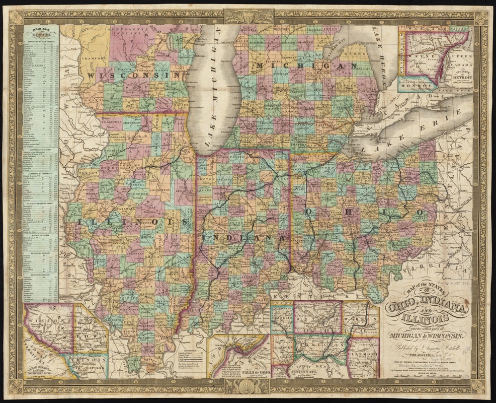
Map of the states of Ohio, Indiana and Illinois with the settled parts of Michigan & Wisconsin
Map of the states of Ohio, Indiana and Illinois with the settled parts of Michigan & Wisconsin
×
Item Information
Title:
Map of the states of Ohio, Indiana and Illinois with the settled parts of Michigan & Wisconsin
Creator:
Mitchell, S. Augustus (Samuel Augustus), 1792-1868
Date:
1845
Format:
Maps/Atlases
Location:
Boston Public Library
Norman B. Leventhal Map Center
Collection (local):
Norman B. Leventhal Map Center Collection
Subjects:
Northwest, Old--Maps
Middle West--Maps
Indiana--Maps
Ohio--Maps
Illinois--Maps
Michigan--Maps
Wisconsin--Maps
Places:
Illinois
Indiana
Ohio
Midwest
(area)
Michigan
Wisconsin
Extent:
1 map : hand col. ; 41 x 52 cm.
Permalink:
https://ark.digitalcommonwealth.org/ark:/50959/7h14b1987
Terms of Use:
No known copyright restrictions.
No known restrictions on use.
Publisher:
Philadelphia : S. Augustus Mitchell ; Sold by Thomas, Cowperthwait & Co.
Scale:
Scale [ca. 1:2,100,000]
Language:
English
Notes:
Prime meridian: Washington.
Insets: Lead region east of the Mississippi River -- Vicinity of Detroit -- Falls of Ohio -- Vicinity of Cincinnati.
Includes table of steam boat routes.
Identifier:
06_01_008716
Call #:
G4070 1845 .M57x
Barcode:
39999065656611
show more...
View MODS XML
More Like This
A map of part of the N:W: Territory of the United States : ...
The great north woods tourist and fishing district of Wisconsin : ...
Post route map of the states of Michigan and Wisconsin showing ...
Post route map of the states of Michigan and Wisconsin showing ...
Find More Like This >>
Tools
Share
Facebook
Pinterest
X
Reddit
Tumblr
Email
Copy link
Add to Folder
Questions/Comments
Cite This Item
IIIF Manifest
Downloads
Primary (full resolution, uncompressed)
(TIF, 69.1 MB)
Large (full resolution)
(JPEG, 5.8 MB)
Medium
(JPEG, 424 KB)
GeoTIFF (georeferenced)
(TIF, 91.5 MB)