Skip to search
Skip to main content
Digital Commonwealth
Sign Up / Log In
Search for
Search
Search
Search
Basic
Advanced
Explore
Map
Collections
Institutions
Formats
For Educators
Primary Source Sets
Lesson Plans
Using Primary Sources
Searching Digital Commonwealth
For Institutions
Join Digital Commonwealth
Conferences, Trainings, & Events
How to Contribute Collections
Digitization Services
Board & Committees
Frequently Asked Questions
About
About Digital Commonwealth
News & Announcements
Copyright & Terms of Use
Harmful Content Statement
Partners
API
Contact Us
Boston Public Library
Norman B. Leventhal Map Center Collection
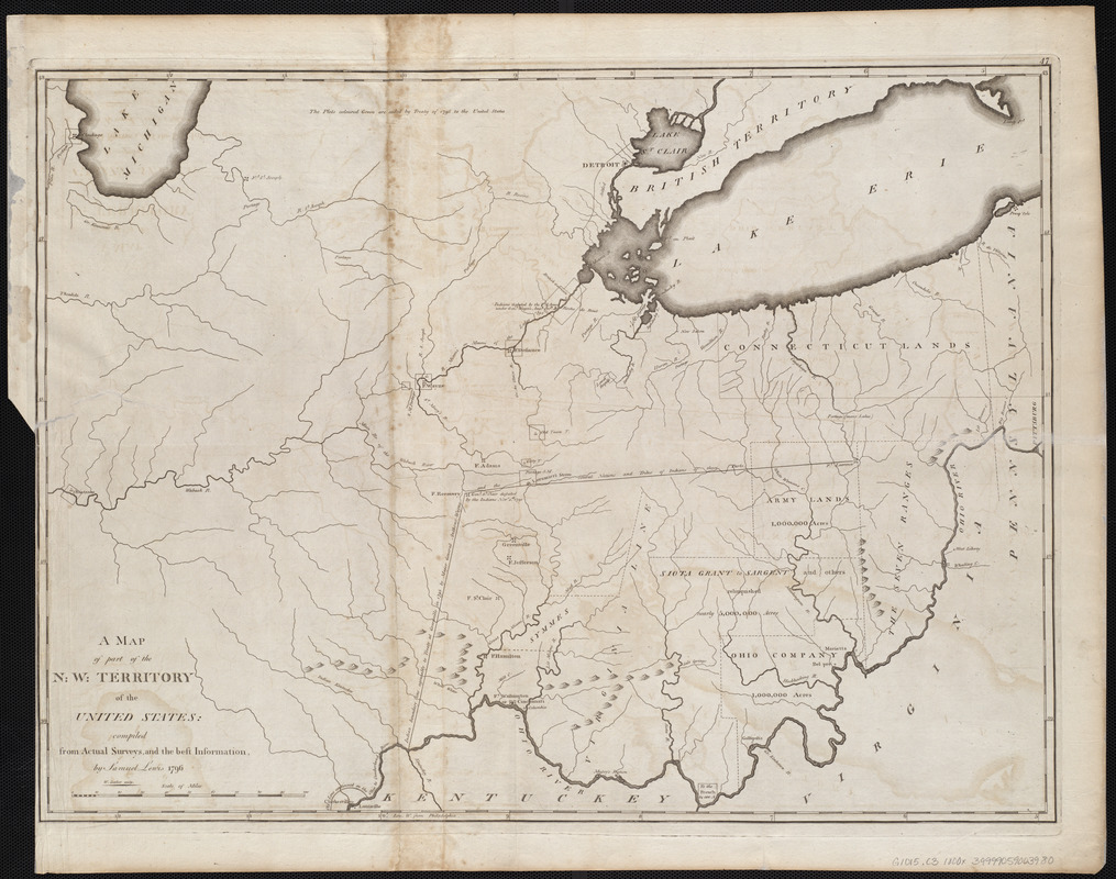
A map of part of the N:W: Territory of the United States : compiled from actual surveys, and the best information
A map of part of the N:W: Territory of the United States
×
Item Information
Title:
A map of part of the N:W: Territory of the United States : compiled from actual surveys, and the best information
Creator:
Lewis, Samuel, 1753 or 4-1822
Cartographer:
Lewis, Samuel, 1753 or 4-1822
Engraver:
Barker, W. (William), active 1795-1803
Publisher:
Carey, Mathew, 1760-1839
Name on Item:
by Samuel Lewis ; W. Barker sculp.
Date:
[1800]
Format:
Maps/Atlases
Location:
Boston Public Library
Norman B. Leventhal Map Center
Collection (local):
Norman B. Leventhal Map Center Collection
Subjects:
Indiana--Maps
Michigan--Maps
Ohio--Maps
Places:
Indiana
Michigan
Ohio
Extent:
1 map ; 47 x 64 cm
Permalink:
https://ark.digitalcommonwealth.org/ark:/50959/3f463052h
Terms of Use:
No known copyright restrictions.
No known restrictions on use.
Publisher:
[Philadelphia] : [Mathew Carey]
Scale:
Scale approximately 1:10,800,000
Language:
English
Notes:
Relief shown pictorially.
Prime meridian: Philadelphia.
In upper right: 47.
Map 47 in his Carey's general atlas. Philadelphia : Mathew Carey, 1800.
Notes (date):
This date is inferred.
Identifier:
06_01_004566
Call #:
G1015 .C3 1800x
Barcode:
30000005058242
show more...
View MODS XML
More Like This
Map of the states of Ohio, Indiana and Illinois with the settled ...
Post route map of the State of Ohio showing post offices with the ...
Post route map of the states of Ohio and Indiana with adjacent ...
The great north woods tourist and fishing district of Wisconsin : ...
Find More Like This >>
Tools
Share
Facebook
Pinterest
X
Reddit
Tumblr
Email
Copy link
Add to Folder
Questions/Comments
Cite This Item
IIIF Manifest
Downloads
Primary (full resolution, uncompressed)
(TIF, 215 MB)
Large (full resolution)
(JPEG, 18 MB)
Medium
(JPEG, 297 KB)