Skip to search
Skip to main content
Digital Commonwealth
Sign Up / Log In
Search for
Search
Search
Search
Basic
Advanced
Explore
Map
Collections
Institutions
Formats
For Educators
Primary Source Sets
Lesson Plans
Using Primary Sources
Searching Digital Commonwealth
For Institutions
Join Digital Commonwealth
Conferences, Trainings, & Events
How to Contribute Collections
Digitization Services
Board & Committees
Frequently Asked Questions
About
About Digital Commonwealth
News & Announcements
Copyright & Terms of Use
Harmful Content Statement
Partners
API
Contact Us
Boston Public Library
Norman B. Leventhal Map Center Collection
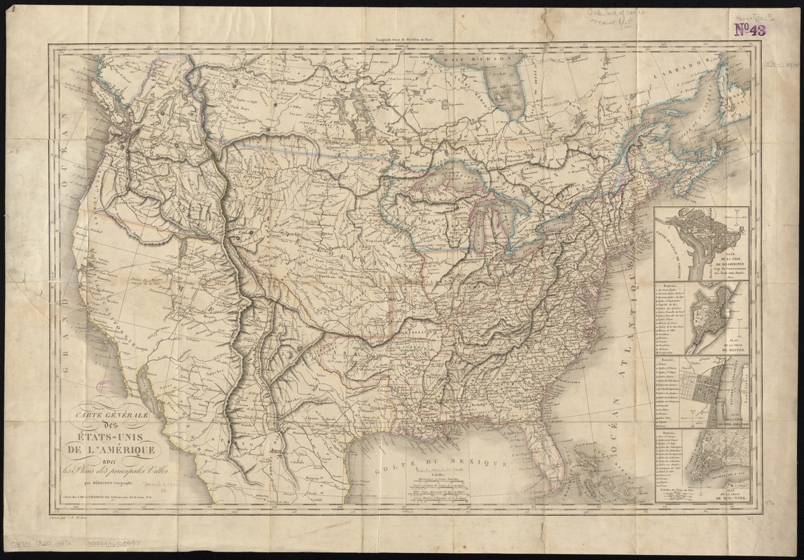
Carte générale des États-Unis de l'Amérique avec les plans des principales villes
Carte générale des États-Unis de lAmérique avec les plans des principales villes
×
Item Information
Title:
Carte générale des États-Unis de l'Amérique avec les plans des principales villes
Creator:
Hérisson, Eustache, b. 1759
Name on Item:
par Hérisson géographe ; gravée par J. B. Tardieu.
Date:
[1820–1829]
Format:
Maps/Atlases
Location:
Boston Public Library
Norman B. Leventhal Map Center
Collection (local):
Norman B. Leventhal Map Center Collection
Subjects:
United States--Maps
Washington (D.C.)--Maps
Boston (Mass.)--Maps
Philadelphia (Pa.)--Maps
New York (N.Y.)--Maps
Places:
Philadelphia (county)
>
Philadelphia
Suffolk (county)
>
Boston
Washington
New York
Extent:
1 map : hand col. ; 48 x 74 cm.
Permalink:
https://ark.digitalcommonwealth.org/ark:/50959/7h149x05f
Terms of Use:
No known copyright restrictions.
No known restrictions on use.
Publisher:
A Paris : Chez A. Bes et F. Dubreuil fils
Scale:
Scale [ca. 1:7,500,000]
Language:
French
Notes:
Relief shown by hachures.
Insets: Plan de la ville de Washington siège du gouvernement des États-Unis depuis 1800 -- Plan de la ville de Boston -- Plan de la ville de Philadelphie -- Plan de la ville de New-York.
Notes (date):
This date is inferred.
Identifier:
06_01_008436
Call #:
G3700 1820 .H47x
Barcode:
39999065654970
show more...
View MODS XML
More Like This
Various plans and draughts of cities, towns, harbours &c. drawn ...
The city of New York as laid out by the Commissioners with the ...
Cyclists' road map of the Philadelphia District
Fac simile of Holmes' map of the Province of Pennsylvania : with ...
Find More Like This >>
Tools
Share
Facebook
Pinterest
X
Reddit
Tumblr
Email
Copy link
Add to Folder
Questions/Comments
Cite This Item
IIIF Manifest
Downloads
Primary (full resolution, uncompressed)
(TIF, 63 MB)
Large (full resolution)
(JPEG, 5.29 MB)
Medium
(JPEG, 371 KB)