Skip to search
Skip to main content
Digital Commonwealth
Sign Up / Log In
Search for
Search
Search
Search
Basic
Advanced
Explore
Map
Collections
Institutions
Formats
For Educators
Primary Source Sets
Lesson Plans
Using Primary Sources
Searching Digital Commonwealth
For Institutions
Join Digital Commonwealth
Conferences, Trainings, & Events
How to Contribute Collections
Digitization Services
Board & Committees
Frequently Asked Questions
About
About Digital Commonwealth
News & Announcements
Copyright & Terms of Use
Harmful Content Statement
Partners
API
Contact Us
Boston Public Library
Norman B. Leventhal Map & Education Center Collection
/
Maritime Charts and Atlases (Collection of Distinction)
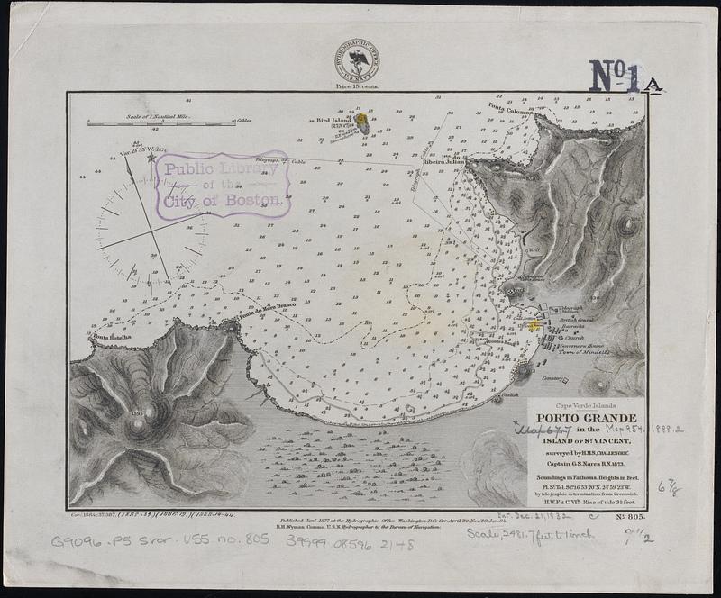
Cape Verde Islands, Porto Grande in the island of St. Vincent
Cape Verde Islands, Porto Grande in the island of St. Vincent
×
Item Information
Title:
Cape Verde Islands, Porto Grande in the island of St. Vincent
Issuing body:
United States. Hydrographic Office
Surveyor:
Nares, George S. (George Strong), 1831-1915
Name on Item:
surveyed by H.M.S. "Challenger", Capt. G.S. Nares R.N. 1873
Date:
[1888]
Format:
Maps/Atlases
Genre:
Nautical charts
Location:
Boston Public Library
Norman B. Leventhal Map & Education Center
Collection (local):
Norman B. Leventhal Map & Education Center Collection
Subjects:
Porto Grande (Cabo Verde)--Maps
Mindelo (Cabo Verde)--Maps
Navigation--Cabo Verde--Porto Grande
Places:
Cape Verde
>
Mindelo
Porto Grande
Extent:
1 map ; 18 x 25 cm
Permalink:
https://ark.digitalcommonwealth.org/ark:/50959/70797x21r
Terms of Use:
No known copyright restrictions.
No known restrictions on use.
Publisher:
Washington, D.C. : Hydrographic Office
Scale:
Scale approximately 1:30,000
Language:
English
Notes:
Relief show by hachures and spot heights. Depths shown by soundings and isolines.
"Cor. April '80. Nov. '80. Jan. 84."
"Cor. (1884,-37,387,(1885.39.)(1886.19.)(1888.14.44."
Notes (date):
This date is inferred.
Identifier:
06_01_017702
Call #:
G9096.P5 svar .U55 no. 805
Barcode:
39999085962148
show more...
View MODS XML
More Like This
The 100th anniversary map of Abraham Lincoln's visit to ...
1630 shoreline
1879. Progress map of the U.S. Geographical Surveys west of the ...
1903 Map of Salem and surrounding places
Find More Like This >>
Tools
Share
Facebook
Pinterest
X
Reddit
Tumblr
Email
Copy link
Add to Folder
Questions/Comments
Cite This Item
IIIF Manifest
Downloads
Primary (full resolution, uncompressed)
(TIF, 30.4 MB)
Large (full resolution)
(JPEG, 2.55 MB)
Medium
(JPEG, 104 KB)
We'd love your feedback!
×
Would you be interested in taking a short survey about Digital Commonwealth?