Skip to search
Skip to main content
Digital Commonwealth
Sign Up / Log In
Search for
Search
Search
Search
Basic
Advanced
Explore
Map
Collections
Institutions
Formats
For Educators
Primary Source Sets
Lesson Plans
Using Primary Sources
Searching Digital Commonwealth
For Institutions
Join Digital Commonwealth
Conferences, Trainings, & Events
How to Contribute Collections
Digitization Services
Board & Committees
Frequently Asked Questions
About
About Digital Commonwealth
News & Announcements
Copyright & Terms of Use
Harmful Content Statement
Partners
API
Contact Us
Boston Public Library
Norman B. Leventhal Map & Education Center Collection
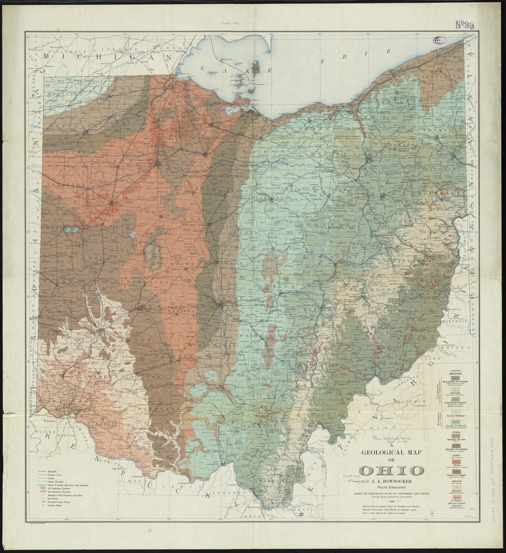
A geological map of Ohio
A geological map of Ohio
×
Item Information
Title:
A geological map of Ohio
Creator:
Bownocker, J. A. (John Adams), 1865-1928
Name on Item:
J.A. Bownocker, State Geologist.
Date:
1909
Format:
Maps/Atlases
Location:
Boston Public Library
Norman B. Leventhal Map & Education Center
Collection (local):
Norman B. Leventhal Map & Education Center Collection
Subjects:
Geology--Ohio--Maps
Ohio--Maps
Places:
Ohio
Extent:
1 map : col. ; 82 x 77 cm.
Permalink:
https://ark.digitalcommonwealth.org/ark:/50959/4m90f8651
Terms of Use:
No known copyright restrictions.
No known restrictions on use.
Publisher:
Columbus : [Geological Survey of Ohio]
Scale:
Scale [1:506,880]. Eight miles to one in.
Language:
English
Notes:
Geologic formations shown by colors and symbols.
"Based on preceding maps by Newberry and Orton."
"A. Hoen & Co., Baltimore, M.D."
Identifier:
06_01_011206
Call #:
G4081.C5 1909 .B69
Barcode:
39999065682450
show more...
View MODS XML
More Like This
Geologic map of Ohio
Being a cartograph of Ohio : the oldest state west of the thirteen ...
Colton's map of the oil district of West Virginia and Ohio
A map of part of the N:W: Territory of the United States : ...
Find More Like This >>
Tools
Share
Facebook
Pinterest
X
Reddit
Tumblr
Email
Copy link
Add to Folder
Questions/Comments
Cite This Item
IIIF Manifest
Downloads
Primary (full resolution, uncompressed)
(TIF, 351 MB)
Large (full resolution)
(JPEG, 29.5 MB)
Medium
(JPEG, 233 KB)