Skip to search
Skip to main content
Digital Commonwealth
Folders
Sign Up / Log In
Search for
Search
Search
Search
Basic
Advanced
Explore
Map
Collections
Institutions
Formats
For Educators
Primary Source Sets
Lesson Plans
Using Primary Sources
Searching Digital Commonwealth
For Institutions
Join Digital Commonwealth
Conferences, Trainings, & Events
How to Contribute Collections
Digitization Services
Board & Committees
Frequently Asked Questions
About
About Digital Commonwealth
News & Announcements
Copyright & Terms of Use
Harmful Content Statement
Partners
API
Contact Us
Boston Public Library
Norman B. Leventhal Map & Education Center Collection
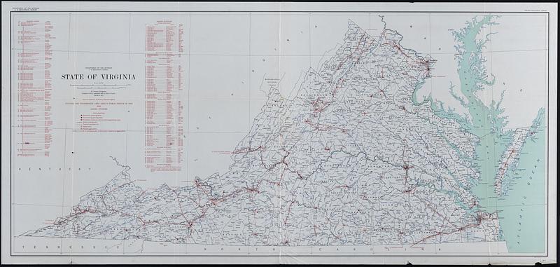
State of Virginia : stations and transmission lines used in public service in 1925 and gaging stations
State of Virginia
×
Item Information
Title:
State of Virginia : stations and transmission lines used in public service in 1925 and gaging stations
Cartographer:
Hassan, A. F.
Contributor:
Horton, A. H. (Albert Howard), 1875-1945
Publisher:
Geological Survey (U.S.)
Contributor:
Virginia Geological Survey
Name on Item:
A.F. Hassan, cartographer ; overprint compiled by A.H. Horton, hydraulic engineer
Date:
1925
Format:
Maps/Atlases
Location:
Boston Public Library
Norman B. Leventhal Map & Education Center
Collection (local):
Norman B. Leventhal Map & Education Center Collection
Subjects:
Virginia--Maps
Power-plants--Virginia--Maps
Electric lines--Virginia--Maps
Places:
Virginia
Extent:
1 map : color ; 61 x 137 cm, on sheet 67 x 163 cm
Permalink:
https://ark.digitalcommonwealth.org/ark:/50959/3j335r84c
Terms of Use:
No known copyright restrictions.
No known restrictions on use.
Publisher:
[Washington, D.C.] : U.S. Geological Survey
Scale:
Scale 1:500,000
Language:
English
Notes:
Includes lists of electric power companies and gaging stations.
"Compiled in 1914 in cooperation with the state of Virginia."
Identifier:
06_01_014856
Call #:
G3881.N3 1925 .G4
Barcode:
39999065707976
show more...
View MODS XML
More Like This
Bacon's Map of the seat of war in Virginia : showing minutely the ...
Coast of North Carolina & Virginia
Colton's new topographical map of the states of Virginia, Maryland ...
Colton's new topographical map of the states of Virginia, West ...
Find More Like This >>
Tools
Share
Facebook
Pinterest
X
Reddit
Tumblr
Email
Copy link
Add to Folder
Questions/Comments
Cite This Item
IIIF Manifest
Downloads
Primary (full resolution, uncompressed)
(TIF, 396 MB)
Large (full resolution)
(JPEG, 33.3 MB)
Medium
(JPEG, 77.2 KB)