Skip to search
Skip to main content
Digital Commonwealth
Sign Up / Log In
Search for
Search
Search
Search
Basic
Advanced
Explore
Map
Collections
Institutions
Formats
For Educators
Primary Source Sets
Lesson Plans
Using Primary Sources
Searching Digital Commonwealth
For Institutions
Join Digital Commonwealth
Conferences, Trainings, & Events
How to Contribute Collections
Digitization Services
Board & Committees
Frequently Asked Questions
About
About Digital Commonwealth
News & Announcements
Copyright & Terms of Use
Harmful Content Statement
Partners
API
Contact Us
Boston Public Library
Norman B. Leventhal Map & Education Center Collection
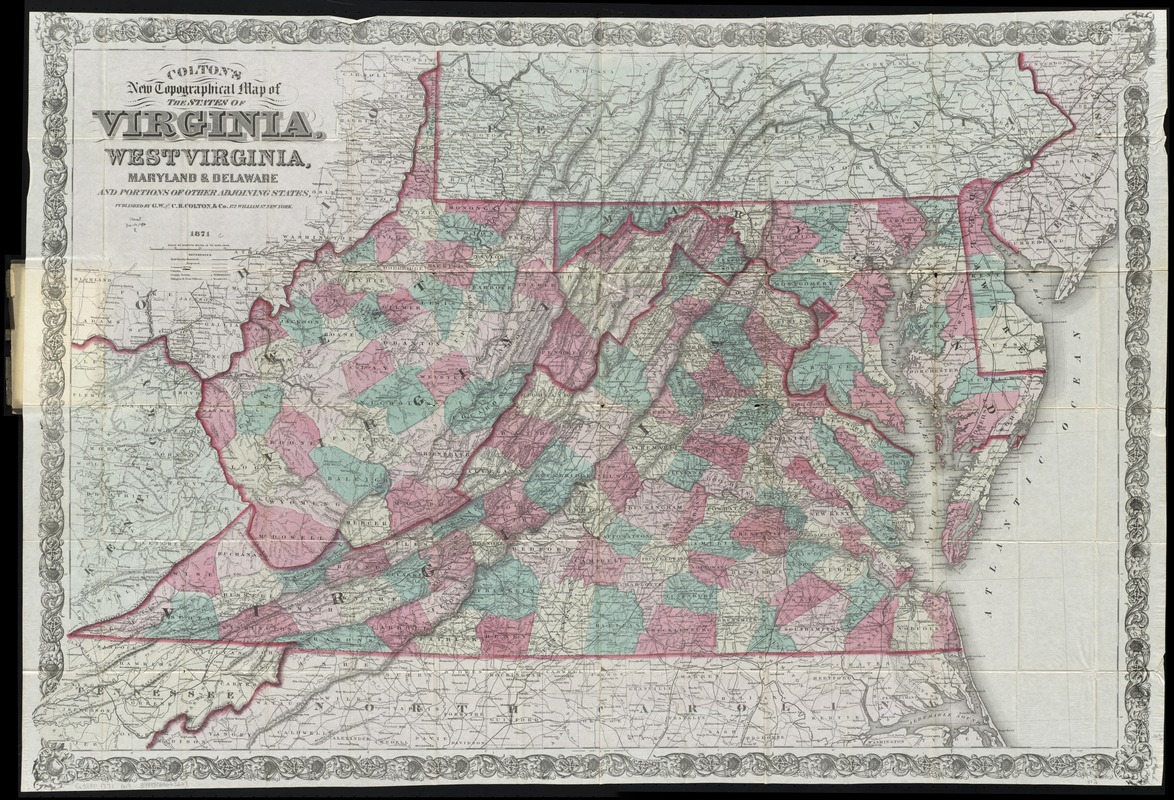
Colton's new topographical map of the states of Virginia, West Virginia, Maryland & Delaware and portions of other adjoining states
Coltons new topographical map of the states of Virginia, West Virginia, Maryland & Delaware and portions of other adjoining states
×
Item Information
Title:
Colton's new topographical map of the states of Virginia, West Virginia, Maryland & Delaware and portions of other adjoining states
Title (alt.):
Colton's map of the states of Virginia, Maryland, Delaware, and West Virginia
Creator:
G.W. & C.B. Colton & Co
Date:
1880
Format:
Maps/Atlases
Location:
Boston Public Library
Norman B. Leventhal Map & Education Center
Collection (local):
Norman B. Leventhal Map & Education Center Collection
Subjects:
Virginia--Maps
West Virginia--Maps
Maryland--Maps
Delaware--Maps
Places:
Virginia
West Virginia
Maryland
Delaware
Extent:
1 map : hand col. ; 73 x 111 cm., folded in cover 16 x 10 cm.
Permalink:
https://ark.digitalcommonwealth.org/ark:/50959/cj82m3433
Terms of Use:
No known copyright restrictions.
No known restrictions on use.
Publisher:
New York : G.W. & C.B. Colton & Co.
Scale:
Scale [1:760,320]. 12 mi. = 1 in.
Language:
English
Notes:
Relief shown by hachures.
Prime meridians: Greenwich and Washington.
Identifier:
06_01_009734
Call #:
G3880 1871 .G19
Barcode:
39999065663229
show more...
View MODS XML
More Like This
Colton's new topographical map of the states of Virginia, Maryland ...
Johnson's Virginia, Delaware, Maryland & West Virginia
Map of the State of Virginia
Post route map of the states of Virginia and West Virginia ...
Find More Like This >>
Tools
Share
Facebook
Pinterest
X
Reddit
Tumblr
Email
Copy link
Add to Folder
Questions/Comments
Cite This Item
IIIF Manifest
Downloads
Primary (full resolution, uncompressed)
(TIF, 177 MB)
Large (full resolution)
(JPEG, 14.9 MB)
Medium
(JPEG, 459 KB)
GeoTIFF (georeferenced)
(TIF, 230 MB)