Boston Public LibraryNorman B. Leventhal Map Center Collection / American Revolutionary War-Era Maps (Collection of Distinction) / Boston and New England Maps (Collection of Distinction) / Maritime Charts and Atlases (Collection of Distinction)
The coast of New England
Item Information
- Title:
- The coast of New England
- Description:
-
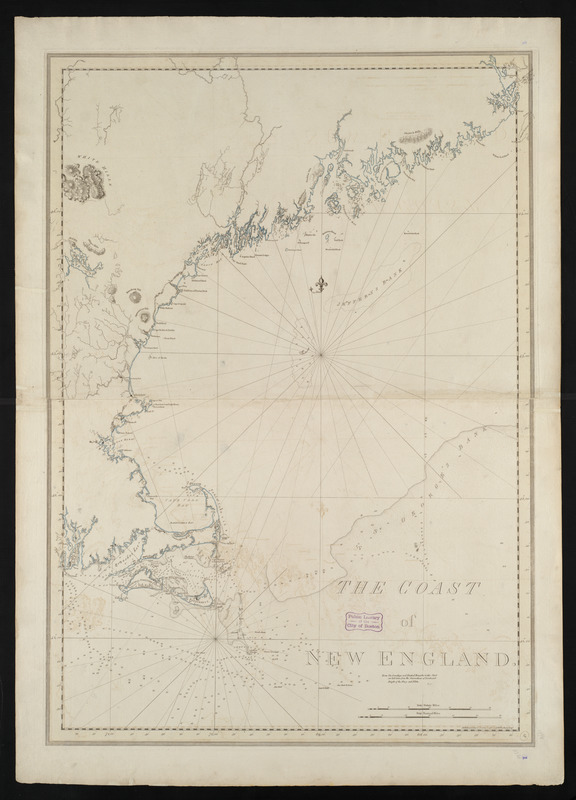
European charts of North America were sadly inadequate prior to the Revolution, but Des Barres’ publication of The Atlantic Neptune more than made up for the deficiency. Displayed here is one of the more general charts, providing an overview, but a very accurate delineation of the New England coast from Cape Cod to Bar Harbor. The atlas, commissioned by the British Admiralty, is undoubtedly the most significant contribution to marine cartography of the North American coast produced in the eighteenth century. The detailed charts, which were based on contemporary surveys, cover the coast from Newfoundland to Carolina depicting every island, cape, bay and harbor.
- Creator:
- Des Barres, Joseph F. W. (Joseph Frederick Wallet), 1722-1824
- Date:
-
1781
- Format:
-
Maps/Atlases
- Location:
-
Boston Public Library
Norman B. Leventhal Map Center - Collection (local):
-
Norman B. Leventhal Map Center Collection
- Subjects:
-
Nautical charts--Atlantic Coast (New England)--Early works to 1800
Coasts--New England--Maps--Early works to 1800
Atlantic Coast (New England)--Maps--Early works to 1800
- Places:
-
New England (area)
- Extent:
- 1 chart : hand col. ; 106 x 74 cm.
- Permalink:
- https://ark.digitalcommonwealth.org/ark:/50959/3f462x63f
- Terms of Use:
-
No known copyright restrictions.
No known restrictions on use.
- Publisher:
-
London :
J.F.W. Des Barres
- Edition:
- 5th state.
- Scale:
-
Scale [ca. 1:520,000]
- Language:
-
English
- Notes:
-
Depths shown by soundings.
Relief shown by hachures.
"Note: The Soundings and Nautical Remarks in this Chart are laid down from the Observations of Lieutenant Knight of the Navy and Pilots."
- Notes (exhibitions):
-
Exhibited: "Charting an Empire: The Atlantic Neptune" organized by the Norman B. Leventhal Map Center at the Boston Public Library, 2013.
- Identifier:
-
06_01_004466
- Call #:
-
G1106.P5 D47 1781
- Barcode:
-
30000002805182
Downloads
- Primary (full resolution, uncompressed)(TIF, 240 MB)
- Large (full resolution)(JPEG, 20.2 MB)
- Medium(JPEG, 145 KB)