Skip to search
Skip to main content
Digital Commonwealth
Sign Up / Log In
Search for
Search
Search
Search
Basic
Advanced
Explore
Map
Collections
Institutions
Formats
For Educators
Primary Source Sets
Lesson Plans
Using Primary Sources
Searching Digital Commonwealth
For Institutions
Join Digital Commonwealth
Conferences, Trainings, & Events
How to Contribute Collections
Digitization Services
Board & Committees
Frequently Asked Questions
About
About Digital Commonwealth
News & Announcements
Copyright & Terms of Use
Harmful Content Statement
Partners
API
Contact Us
Boston Public Library
Norman B. Leventhal Map Center Collection
/
Boston and New England Maps (Collection of Distinction)
/
Maritime Charts and Atlases (Collection of Distinction)
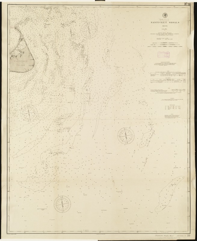
Nantucket Shoals, Mass
Nantucket Shoals, Mass
×
Item Information
Title:
Nantucket Shoals, Mass
Creator:
U.S. Coast and Geodetic Survey
Date:
1893
Format:
Maps/Atlases
Location:
Boston Public Library
Norman B. Leventhal Map Center
Collection (local):
Norman B. Leventhal Map Center Collection
Subjects:
Nautical charts--Massachusetts--Nantucket Shoals
Nantucket Shoals (Mass.)--Maps
Places:
Nantucket (county)
>
Nantucket Shoals
(area)
Extent:
1 map ; 106 x 84 cm.
Permalink:
https://ark.digitalcommonwealth.org/ark:/50959/1257bb683
Terms of Use:
No known copyright restrictions.
No known restrictions on use.
Publisher:
[Washington, D.C.] : United States Coast and Geodetic Survey
Scale:
Scale 1:80,000.
Language:
English
Notes:
Depths shown by soundings.
"No. 213" in margins.
"Topography executed in 1887. Hydrography [executed] between 1890 and 1892."
Includes information on weather signal stations, lights, light vessels, tides, soundings and buoys.
Identifier:
06_01_005168
Call #:
G3762.N325P5 1893 .U8
Barcode:
39999059010072
show more...
View MODS XML
More Like This
Chart of the Vineyard Sound and Nantucket Shoals
A new chart of Nantucket Shoals & George's Bank with the adjacent ...
Preliminary sketch showing the positions of Davis's Shoal and ...
Preliminary sketch showing the positions of Davis' Shoal and other ...
Find More Like This >>
Tools
Share
Facebook
Pinterest
X
Reddit
Tumblr
Email
Copy link
Add to Folder
Questions/Comments
Cite This Item
IIIF Manifest
Downloads
Primary (full resolution, uncompressed)
(TIF, 166 MB)
Large (full resolution)
(JPEG, 14 MB)
Medium
(JPEG, 150 KB)