Skip to search
Skip to main content
Digital Commonwealth
Sign Up / Log In
Search for
Search
Search
Search
Basic
Advanced
Explore
Map
Collections
Institutions
Formats
For Educators
Primary Source Sets
Lesson Plans
Using Primary Sources
Searching Digital Commonwealth
For Institutions
Join Digital Commonwealth
Conferences, Trainings, & Events
How to Contribute Collections
Digitization Services
Board & Committees
Frequently Asked Questions
About
About Digital Commonwealth
News & Announcements
Copyright & Terms of Use
Harmful Content Statement
Partners
API
Contact Us
Boston Public Library
Norman B. Leventhal Map & Education Center Collection
/
Maritime Charts and Atlases (Collection of Distinction)
West Indies, west coast of Haiti, Port au Prince : from a French survey in 1847 corrected for the latest information, 1886
West Indies, west coast of Haiti, Port au Prince
×
Item Information
Title:
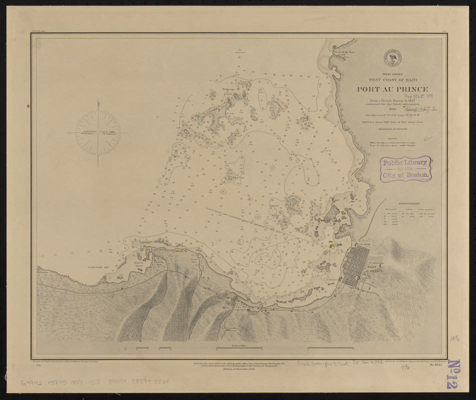
West Indies, west coast of Haiti, Port au Prince : from a French survey in 1847 corrected for the latest information, 1886
Title (alt.):
Port au Prince
Issuing body:
United States. Hydrographic Office
Engraver:
Franke, M. (Max)
Engraver:
Ruebsam, E. A. (E. August)
Name on Item:
drawn by A.C. Roberts ; engraved by M. Franke and E.A. Ruebsam
Date:
1888
Format:
Maps/Atlases
Location:
Boston Public Library
Norman B. Leventhal Map & Education Center
Collection (local):
Norman B. Leventhal Map & Education Center Collection
Subjects:
Nautical charts--Haiti--Port-au-Prince Bay
Port-au-Prince Bay (Haiti)--Maps
Port-au-Prince (Haiti)--Maps
Places:
Haiti
>
Ouest
>
Port-au-Prince, Baie de
(bay)
Extent:
1 map ; 35 x 45 cm
Permalink:
https://ark.digitalcommonwealth.org/ark:/50959/0z709d30d
Terms of Use:
No known copyright restrictions.
No known restrictions on use.
Publisher:
Washington, D.C. : Hydrographic Office
Edition:
Edition of December 1888
Scale:
Scale approximately 1:37,000
Language:
English
Notes:
Relief shown by shading and form lines. Depths shown by soundings and isolines.
Identifier:
06_01_015746
Call #:
G9096.P5 svar .U55
Barcode:
39999085940060
show more...
View MODS XML
More Like This
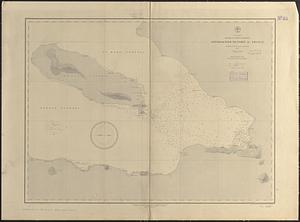
West Indies, island of Santo Domingo, approaches to Port au Prince ...
Kingston-Port-au-Prince
Vue du Port-au-Prince et ses environs
The 100th anniversary map of Abraham Lincoln's visit to ...
Find More Like This >>
Tools
Share
Facebook
Pinterest
X
Reddit
Tumblr
Email
Copy link
Add to Folder
Questions/Comments
Cite This Item
IIIF Manifest
Downloads
Primary (full resolution, uncompressed)
(TIF, 47.8 MB)
Large (full resolution)
(JPEG, 4.02 MB)
Medium
(JPEG, 220 KB)