Skip to search
Skip to main content
Digital Commonwealth
Sign Up / Log In
Search for
Search
Search
Search
Basic
Advanced
Explore
Map
Collections
Institutions
Formats
For Educators
Primary Source Sets
Lesson Plans
Using Primary Sources
Searching Digital Commonwealth
For Institutions
Join Digital Commonwealth
Conferences, Trainings, & Events
How to Contribute Collections
Digitization Services
Board & Committees
Frequently Asked Questions
About
About Digital Commonwealth
News & Announcements
Copyright & Terms of Use
Harmful Content Statement
Partners
API
Contact Us
Boston Public Library
Norman B. Leventhal Map Center Collection
/
Maritime Charts and Atlases (Collection of Distinction)
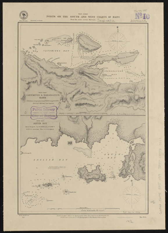
West Indies, ports on the south and west coasts of Haiti : from the most recent surveys
West Indies, ports on the south and west coasts of Haiti
×
Item Information
Title:
West Indies, ports on the south and west coasts of Haiti : from the most recent surveys
Title (alt.):
Ports on the south and west coasts of Haiti
Issuing body:
United States. Hydrographic Office
Engraver:
Franke, M. (Max)
Printer:
Leggo Bros. & Co.
Name on Item:
drawn by M. Franke
Date:
1885
Format:
Maps/Atlases
Location:
Boston Public Library
Norman B. Leventhal Map Center
Collection (local):
Norman B. Leventhal Map Center Collection
Subjects:
Coasts--Haiti--Maps
Nautical charts--Haiti--Baradères Bay
Nautical charts--Haiti--Cayemites Bay
Nautical charts--Haiti--Aquin Bay
Nautical charts--Haiti--English Bay
Baradères Bay (Haiti)--Maps
Cayemites Bay (Haiti)--Maps
Aquin Bay (Haiti)--Maps
English Bay (Haiti)--Maps
Places:
Nippes
>
Baradères, Baie des
(bay)
Grand'Anse
>
Cayemites, Baie des
(bay)
Sud
>
Aquin
Baie Anglaise
Extent:
2 maps on 1 sheet ; 40 x 27 cm
Permalink:
https://ark.digitalcommonwealth.org/ark:/50959/0z709978z
Terms of Use:
No known copyright restrictions.
No known restrictions on use.
Publisher:
Washington, D.C. : Hydrographic Office
Scale:
Scale approximately 1:59,900
Scale approximately 1:200,000
Language:
English
Table of Contents:
West coast, Cayemites & Baradaires Bays
South coast, Aquin Bay.
Notes:
Relief shown by hachures. Depths shown by soundings and isolines.
Identifier:
06_01_015739
Call #:
G9096.P5 svar .U55
Barcode:
39999085939997
show more...
View MODS XML
More Like This
West Indies, Haiti or Santo Domingo, Cayes, Flamand, St. Louis and ...
West Indies, ports on the north and west coasts of Haiti : from ...
West Indies, ports on the north west coast of Haiti : from the ...
The 100th anniversary map of Abraham Lincoln's visit to ...
Find More Like This >>
Tools
Share
Facebook
Pinterest
X
Reddit
Tumblr
Email
Copy link
Add to Folder
Questions/Comments
Cite This Item
IIIF Manifest
Downloads
Primary (full resolution, uncompressed)
(TIF, 37.4 MB)
Large (full resolution)
(JPEG, 3.14 MB)
Medium
(JPEG, 153 KB)