Skip to search
Skip to main content
Digital Commonwealth
Folders
Sign Up / Log In
Search for
Search
Search
Search
Basic
Advanced
Explore
Map
Collections
Institutions
Formats
For Educators
Primary Source Sets
Lesson Plans
Using Primary Sources
Searching Digital Commonwealth
For Institutions
Join Digital Commonwealth
Conferences, Trainings, & Events
How to Contribute Collections
Digitization Services
Board & Committees
Frequently Asked Questions
About
About Digital Commonwealth
News & Announcements
Copyright & Terms of Use
Harmful Content Statement
Partners
API
Contact Us
Boston Public Library
Norman B. Leventhal Map & Education Center Collection
/
Maritime Charts and Atlases (Collection of Distinction)
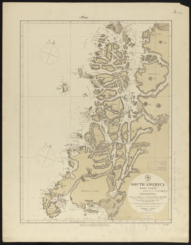
South America, west coast : republication of Brit. Admty. chart no. 1325, with additions to 1876
South America, west coast
×
Item Information
Title:
South America, west coast : republication of Brit. Admty. chart no. 1325, with additions to 1876
Title (alt.):
Patagonia, Gulf of Peñas to the Guaitecas Islands, including the channels of the Guaitecas and Chonos Archgos
Issuing body:
United States. Hydrographic Office
Date:
1876
Format:
Maps/Atlases
Location:
Boston Public Library
Norman B. Leventhal Map & Education Center
Collection (local):
Norman B. Leventhal Map & Education Center Collection
Subjects:
Coasts--Chile--Maps
Nautical charts--Chile--Chonos Archipelago
Nautical charts--Chile--Guaitecas Archipelago
Nautical charts--Chile--Moraleda Channel
Chonos Archipelago (Chile)--Maps
Guaitecas Archipelago (Chile)--Maps
Moraleda Channel (Chile)--Maps
Taitao Peninsula (Chile)--Maps
Places:
Chile
>
Aysén
(region)
>
Chonos, Archipiélago de los
(archipelago)
Chile
>
Aysén
(region)
>
Moraleda, Canal
(strait)
Chile
>
Aysén
(region)
>
Taitao, Península de
(area)
Chile
>
Aysén
(region)
>
Guaitecas, Archipiélago de las
(area)
Extent:
1 map ; 62 x 44 cm
Permalink:
https://ark.digitalcommonwealth.org/ark:/50959/0z7099380
Terms of Use:
No known copyright restrictions.
No known restrictions on use.
Publisher:
Washington, D.C. : Hydrographic Office
Scale:
Scale approximately 1:630,000
Language:
English
Notes:
Relief shown by hachures and spot heights. Depths shown by soundings.
Identifier:
06_01_015769
Call #:
G9096.P5 svar .U55
Barcode:
39999085939724
show more...
View MODS XML
More Like This
Plans on the west coast of Patagonia, South America : from the ...
South America, ports in Desolation and Sta. Ines Is. : from ...
South America, ports in the Strait of Magellan : from British ...
South America, west coast : republication of Brit. Admty. chart ...
Find More Like This >>
Tools
Share
Facebook
Pinterest
X
Reddit
Tumblr
Email
Copy link
Add to Folder
Questions/Comments
Cite This Item
IIIF Manifest
Downloads
Primary (full resolution, uncompressed)
(TIF, 88.1 MB)
Large (full resolution)
(JPEG, 7.39 MB)
Medium
(JPEG, 173 KB)