Skip to search
Skip to main content
Digital Commonwealth
Sign Up / Log In
Search for
Search
Search
Search
Basic
Advanced
Explore
Map
Collections
Institutions
Formats
For Educators
Primary Source Sets
Lesson Plans
Using Primary Sources
Searching Digital Commonwealth
For Institutions
Join Digital Commonwealth
Conferences, Trainings, & Events
How to Contribute Collections
Digitization Services
Board & Committees
Frequently Asked Questions
About
About Digital Commonwealth
News & Announcements
Copyright & Terms of Use
Harmful Content Statement
Partners
API
Contact Us
Boston Public Library
Norman B. Leventhal Map Center Collection
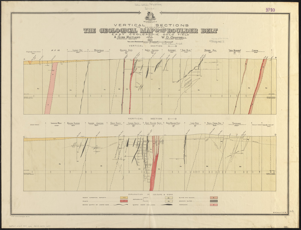
Vertical sections to accompany the geological map of the Boulder Belt, East Coolgardie, G.F.
Vertical sections to accompany the geological map of the Boulder Belt, East Coolgardie, G.F.
×
Item Information
Title:
Vertical sections to accompany the geological map of the Boulder Belt, East Coolgardie, G.F.
Cartographer:
Geological Survey of Western Australia
Cartographer:
Maitland, A. Gibb
Cartographer:
Campbell, William Dugald
Cartographer:
Irwin, R. H.
Name on Item:
by A. Gibb Maitland, government geologist, and W.D. Campbell, assistant geologist ; R.H. Irwin del.
Date:
1903
Format:
Maps/Atlases
Location:
Boston Public Library
Norman B. Leventhal Map Center
Collection (local):
Norman B. Leventhal Map Center Collection
Subjects:
Geology--Australia--Kalgoorlie (W.A.)--Maps
Kalgoorlie (W.A.)--Maps
Geological cross-sections
Places:
Australia
>
Kalgoorlie
Extent:
2 cross-sections on 1 sheet : color ; 68 x 94 cm
Permalink:
https://ark.digitalcommonwealth.org/ark:/50959/0z7098588
Terms of Use:
No known copyright restrictions.
No known restrictions on use.
Publisher:
Western Australia : Geological Survey of Western Australia
Scale:
Scale approximately 1:3,168
Language:
English
Table of Contents:
Vertical section A-B [Ivanhoe Venture - Curfew]
Vertical section C-D [Boulder Township - Wild Cat].
Notes:
Accompanies Geological map of the Boulder belt, East Coolgardie G.F.
Identifier:
06_01_015402
Call #:
G8964.K3C5 1903 .G46
Barcode:
39999085936274
show more...
View MODS XML
More Like This
Geologic sections in T. 56 N., Rs. 32 and 33 W.
Plano de Madrid, dividido en diez quarteles
The 100th anniversary map of Abraham Lincoln's visit to ...
1630 shoreline
Find More Like This >>
Tools
Share
Facebook
Pinterest
X
Reddit
Tumblr
Email
Copy link
Add to Folder
Questions/Comments
Cite This Item
IIIF Manifest
Downloads
Primary (full resolution, uncompressed)
(TIF, 135 MB)
Large (full resolution)
(JPEG, 11.4 MB)
Medium
(JPEG, 223 KB)