Skip to search
Skip to main content
Digital Commonwealth
Sign Up / Log In
Search for
Search
Search
Search
Basic
Advanced
Explore
Map
Collections
Institutions
Formats
For Educators
Primary Source Sets
Lesson Plans
Using Primary Sources
Searching Digital Commonwealth
For Institutions
Join Digital Commonwealth
Conferences, Trainings, & Events
How to Contribute Collections
Digitization Services
Board & Committees
Frequently Asked Questions
About
About Digital Commonwealth
News & Announcements
Copyright & Terms of Use
Harmful Content Statement
Partners
API
Contact Us
Boston Public Library
Norman B. Leventhal Map Center Collection
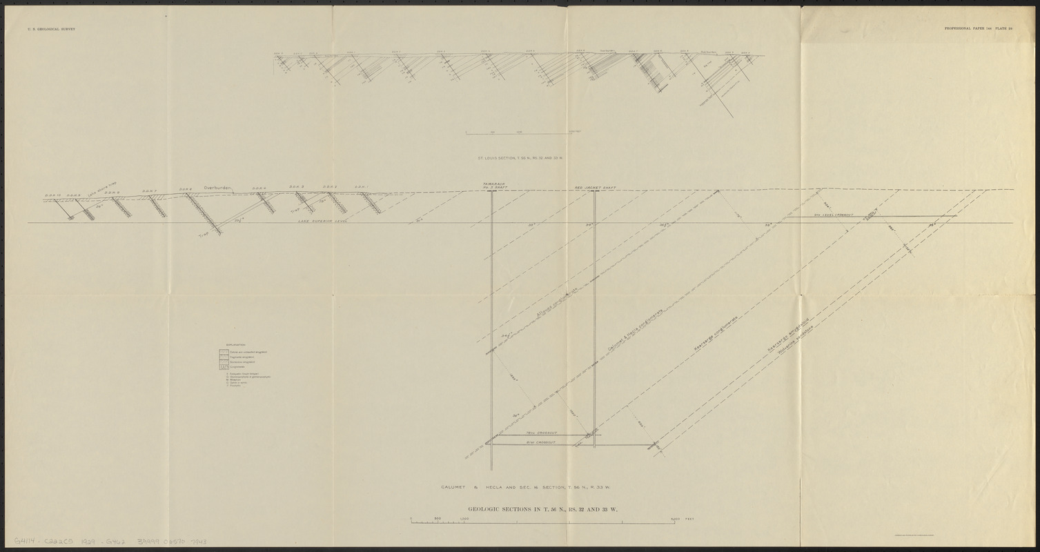
Geologic sections in T. 56 N., Rs. 32 and 33 W.
Geologic sections in T. 56 N., Rs. 32 and 33 W.
×
Item Information
Title:
Geologic sections in T. 56 N., Rs. 32 and 33 W.
Cartographer:
Geological Survey (U.S.)
Contributor:
Butler, B. S. (Bert Sylvenus), 1877-1960
Date:
1929
Format:
Maps/Atlases
Location:
Boston Public Library
Norman B. Leventhal Map Center
Collection (local):
Norman B. Leventhal Map Center Collection
Subjects:
Geological cross sections--Michigan--Calumet Township--Maps
Geology--Michigan--Calumet Township--Maps
Calumet Township (Mich.)--Maps
Geological cross-sections
Places:
Houghton (county)
>
Calumet
Extent:
2 sections on 1 sheet ; sheet 53 x 99 cm
Permalink:
https://ark.digitalcommonwealth.org/ark:/50959/0z709397x
Terms of Use:
No known copyright restrictions.
No known restrictions on use.
Publisher:
[Washington, D.C.] : [Government Printing Office]
Scale:
Scale approximately 1:6,000
Language:
English
Table of Contents:
St. Louis section, T. 56N., Rs. 32 and 33 W.
Calumet & Hecla and sec. 16 section, T. 56N., R. 33 W.
Notes:
Professional paper 144 plate 20.
From The copper deposits of Michigan (Washington, D.C. : G.P.O, 1929).
Identifier:
06_01_014853
Call #:
G4114.C222C5 1929 .G462
Barcode:
39999065707943
show more...
View MODS XML
More Like This
Geologic sections in T. 56 N., R. 33 W.
Plano de Madrid, dividido en diez quarteles
Vertical sections to accompany the geological map of the Boulder ...
The 100th anniversary map of Abraham Lincoln's visit to ...
Find More Like This >>
Tools
Share
Facebook
Pinterest
X
Reddit
Tumblr
Email
Copy link
Add to Folder
Questions/Comments
Cite This Item
IIIF Manifest
Downloads
Primary (full resolution, uncompressed)
(TIF, 89.9 MB)
Large (full resolution)
(JPEG, 7.54 MB)
Medium
(JPEG, 192 KB)