Skip to search
Skip to main content
Skip to first result
Digital Commonwealth
Folders
Sign Up / Log In
Search for
Search
Search
Search
Basic
Advanced
Explore
Map
Collections
Institutions
Formats
For Educators
Primary Source Sets
Lesson Plans
Using Primary Sources
Searching Digital Commonwealth
For Institutions
Join Digital Commonwealth
Conferences, Trainings, & Events
How to Contribute Collections
Digitization Services
Board & Committees
Frequently Asked Questions
About
About Digital Commonwealth
News & Announcements
Copyright & Terms of Use
Harmful Content Statement
Partners
API
Contact Us
Search
Search Constraints
Start Over
Save Search
Your search:
More Like
commonwealth-oai:ww72bj185
✖
Remove constraint More Like: commonwealth-oai:ww72bj185
« Prev.
|
41
-
60
of
368
|
Next »
Sort
by date (desc)
relevance
title
date (asc)
date (desc)
Number of results to display per page
20
per page
per page
10
per page
20
per page
50
per page
100
per page
View results as:
List
list view
Maps
map view
Gallery
grid view
Search Results
41.
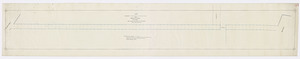
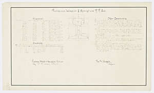
Map and profile of the Providence, Ponaganset and Springfield Railroad within the State of Massachusetts.
42.
Twenty-second annual report of the Board of Railroad Commissioners (1890)
43.
Map showing the lines of preliminary survey and office location line of the Plymouth and Middleboro Railroad / James M. Hodge,...
44.
Twenty-first annual report of the Board of Railroad Commissioners (1889)
45.
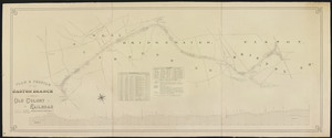
Plan & profile of the Easton branch of Old Colony Railroad / Charles F. Choate, president George S. Morrill, Chief Engr.
46.
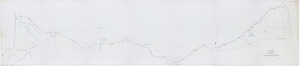
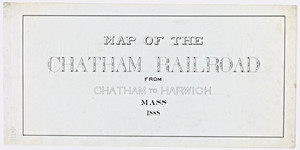
Map of the Chatham Railroad from Chatham to Harwich, Mass.
47.
Twentieth annual report of the Board of Railroad Commissioners (1888)
48.
Nineteenth annual report of the Board of Railroad Commissioners (1887)
49.
Plan of freight bridge over Charles River on the Boston & Lowell railroad: being the first passenger bridge.
50.
Eighteenth annual report of the Board of Railroad Commissioners (1886)
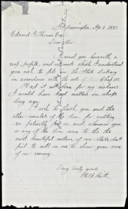
51.
Letter to Edward F. Thomas, 1885
52.
Map and profile showing by the red line the proposed extension of the Poughkeepsie, Hartford and Boston R.R. to Chicopee, Mass.
53.
Seventeenth annual report of the Board of Railroad Commissioners (1885)
54.
Sixteenth annual report of the Board of Railroad Commissioners (1884)
55.
Fifteenth annual report of the Board of Railroad Commissioners (1883)
56.
Map and profile of a branch of the Old colony railroad in the city of Taunton & the town of Raynham / drawn by E.H. Brooks, C.E.
57.
Map and profile of a branch of the Old Colony railroad in the town of Braintree, Norfolk county.
58.
Map and profile of the Providence, Webster and Springfield railroad.
59.
Map and profile of the Providence, Webster and Springfield railroad extension.
60.
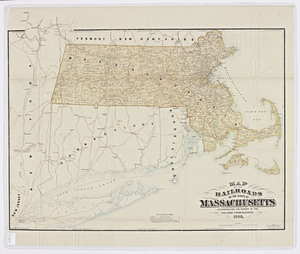
Map of the railroads of the state of Massachusetts: accompanying the report of the Railroad Commissioners.
« Previous
Next »
1
2
3
4
5
6
7
…
18
19
Limit your search
Subject
Railroads--Massachusetts
59
Railroads--Massachusetts--Maps
13
Massachusetts--Maps
9
Old Colony Railroad
8
Boston and Maine Railroad--Maps
7
Massachusetts. Board of Railroad Commissioners
7
Massachusetts. Public Service Commission
7
Public utilities--Massachusetts
7
more
Subject
»
Place
North and Central America
368
United States
368
Massachusetts
356
Middlesex (county)
91
Boston
71
Suffolk (county)
71
Norfolk (county)
46
Essex (county)
43
more
Place
»
Format
Maps/Atlases
269
Documents
99
Date
View distribution
Current results range from
1827
to
1919
Date range begin
Date range end
View larger »
Unknown
56
Collection
Massachusetts Board of Railroad Commissioners
368
Institution
State Library of Massachusetts
368