Skip to search
Skip to main content
Skip to first result
Digital Commonwealth
Folders
Sign Up / Log In
Search for
Search
Search
Search
Basic
Advanced
Explore
Map
Collections
Institutions
Formats
For Educators
Primary Source Sets
Lesson Plans
Using Primary Sources
Searching Digital Commonwealth
For Institutions
Join Digital Commonwealth
Conferences, Trainings, & Events
How to Contribute Collections
Digitization Services
Board & Committees
Frequently Asked Questions
About
About Digital Commonwealth
News & Announcements
Copyright & Terms of Use
Harmful Content Statement
Partners
API
Contact Us
Search
Search Constraints
Start Over
Save Search
Your search:
More Like
commonwealth:vh53xt23r
✖
Remove constraint More Like: commonwealth:vh53xt23r
« Prev.
|
761
-
780
of
817
|
Next »
Sort
by relevance
relevance
title
date (asc)
date (desc)
Number of results to display per page
20
per page
per page
10
per page
20
per page
50
per page
100
per page
View results as:
List
list view
Maps
map view
Gallery
grid view
Search Results
761.
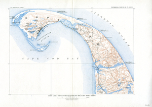
Coast Lines: Part of Provincetown and Wellfleet (Mass.) Sheets
762.
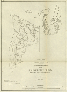
Comparative Sketch of the Handkerchief Shoal Entrance to Nantucket Sound, Mass. Showing its Increase
763.
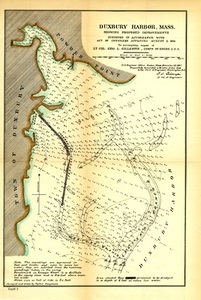
Duxbury Harbor, Mass. Showing Proposed Improvements
764.
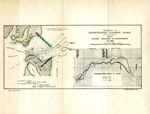
Entrance of Newburyport Harbor, Mass.: Plan Showing Condition of Improvement
765.
Essex County
766.
Geologic Map of Cape Ann, Mass.: Showing Distribution of Dikes, etc.
767.
Gloucester
768.
Gloucester
769.
Gloucester Harbor, Massachusetts
770.
Gloucester Harbor, Massachusetts
771.
Gloucester Harbor, Massachusetts: Inner Harbor
772.
Harbor of Refuge at Hyannis, Mass.
773.
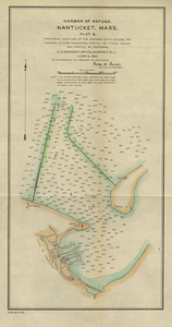
Harbor of Refuge, Nantucket, Mass., Plat B Proposed Location of the Eastern Jetty in Case the Channel is to Be Excavated Partly...
774.
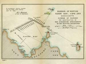
Harbor of Refuge, Sandy Bay, Cape Ann, Massachusetts: Scheme of Ranges for the Construction of the Submerged Enrockment of the...
775.
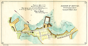
Harbor of Refuge, Woods Holl, Mass.
776.
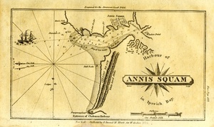
Harbour of Annis Squam in Ipswich Bay.
777.
Historical Map of Nantucket
778.
Hyannis Harbor, Mass.: Surveyed in Accordance With an Act of Congress of July 5 1884, Under the Direction of George H. Elliot,...
779.
Lanesville, Bay View, Annisquam
780.
Manchester Harbor, Mass.Suveyed in Accordance with Act of Congress Approved August 5, 1886 Showing Proposed Improvements.
« Previous
Next »
1
2
…
35
36
37
38
39
40
41
Limit your search
Subject
Coastal
812
Regional Studies
738
Agriculture
71
Massachusetts
70
Hurricanes
27
Conservation and Management
23
Historic and Retrospective Studies
21
Birds
20
more
Subject
»
Place
North and Central America
807
United States
807
Dukes (county)
698
Martha's Vineyard
604
Massachusetts
548
Chilmark
161
West Tisbury
123
Chappaquiddick Island
90
more
Place
»
Format
Photographs
621
Maps/Atlases
139
Objects/Artifacts
121
Postcards/Cards
1
Drawings/Illustrations
1
Available to use
Creative Commons license
743
Date
View distribution
Current results range from
1764
to
2016
Date range begin
Date range end
View larger »
Unknown
1
Collection
Harvard Forest Martha's Vineyard Collection
744
Historic Maps
73
Institution
Harvard University
738
Salem State University Archives and Special Collections
73
Martha's Vineyard Museum
4
The Vineyard Gazette
2