Skip to search
Skip to main content
Skip to first result
Digital Commonwealth
Folders
Sign Up / Log In
Search for
Search
Search
Search
Basic
Advanced
Explore
Map
Collections
Institutions
Formats
For Educators
Primary Source Sets
Lesson Plans
Using Primary Sources
Searching Digital Commonwealth
For Institutions
Join Digital Commonwealth
Conferences, Trainings, & Events
How to Contribute Collections
Digitization Services
Board & Committees
Frequently Asked Questions
About
About Digital Commonwealth
News & Announcements
Copyright & Terms of Use
Harmful Content Statement
Partners
API
Contact Us
Search
Search Constraints
Start Over
Save Search
Your search:
More Like
commonwealth:q524n353r
✖
Remove constraint More Like: commonwealth:q524n353r
« Prev.
|
10,741
-
10,760
of
11,007
|
Next »
Sort
by relevance
relevance
title
date (asc)
date (desc)
Number of results to display per page
20
per page
per page
10
per page
20
per page
50
per page
100
per page
View results as:
List
list view
Maps
map view
Gallery
grid view
Search Results
10741.
Views of London in 1616 and 1890
10742.
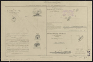
Views of Lot's Wife, taken from Meares' Voyage and from the sketch-book of the U.S. Ship Vincennes, November 1854 ; Borodino...
10743.
Views of Lot's Wife, taken from Meares' Voyage and from the sketch-book of the U.S. Ship Vincennes, November 1854 ; Borodino...
10744.
Views of the area around Dudley Station in Roxbury
10745.
Views of the Boston Harbor Islands
10746.
[Views of the Boston Harbor Islands]
10747.
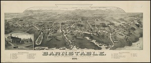
Village of Barnstable, seat of Barnstable County, Mass : 1884
10748.
Village of Kingston, Plymouth County, Mass : 1885
10749.
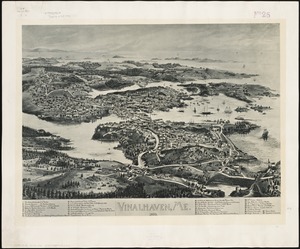
Vinalhaven, Me : 1893
10750.
Vineyard Haven, Dukes County, Martha's Vineyard, Massachusetts : the popular seaside summer resort
10751.
Vineyard Sound and Buzzards Bay, Massachusetts
10752.
Virginia
10753.
Virginia
10754.
Virginia
10755.
Virginia and Maryland
10756.
Virginia, Maryland, Pennsilvania, east & west New Jarsey
10757.
Virginia Marylandia et Carolina in America septentrionali Brittannorum industria excultæ
10758.
Virginiae item et Floridae Americae provincarum, nova descriptio
10759.
Virginiae item et Floridae Americae provinciarum, nova descriptio
10760.
Virginiae partis australis et Floridae partis orientalis, interjacentium[que] regionum nova descriptio
« Previous
Next »
1
2
…
534
535
536
537
538
539
540
541
542
…
550
551
Limit your search
Subject
Real property--Massachusetts--Boston--Maps
2,278
Landowners--Massachusetts--Boston--Maps
2,117
Boston (Mass.)--Maps
1,967
Roxbury (Boston, Mass.)--Maps
351
Dorchester (Boston, Mass.)--Maps
317
Cambridge (Mass.)--Maps
266
Brookline (Mass.)--Maps
236
Real property--Massachusetts--Cambridge--Maps
216
more
Subject
»
Place
North and Central America
7,816
United States
6,577
Suffolk (county)
3,339
Boston
3,199
Massachusetts
3,176
Europe
963
Middlesex (county)
617
Canada
427
more
Place
»
Format
Maps/Atlases
10,947
Manuscripts
215
Prints
51
Books
35
Objects/Artifacts
10
Drawings/Illustrations
8
Posters
4
Photographs
1
Available to use
No known restrictions
10,934
Creative Commons license
46
Date
View distribution
Current results range from
1482
to
2023
Date range begin
Date range end
View larger »
Collection
Norman B. Leventhal Map Center Collection
11,003
Boston and New England Maps (Collection of Distinction)
5,107
Urban Maps (Collection of Distinction)
4,847
Maritime Charts and Atlases (Collection of Distinction)
750
American Revolutionary War-Era Maps (Collection of Distinction)
615
Boston Redevelopment Authority Collection
87
Sidney R. Knafel Map Collection at Phillips Academy
2
Chinese Progressive Association Records
1
Institution
Boston Public Library
11,004
Phillips Academy
2
Northeastern University Library
1


![[Views of the Boston Harbor Islands]](https://bpldcassets.blob.core.windows.net/derivatives/images/commonwealth:1v53jx85b/image_thumbnail_300.jpg)


![Virginiae partis australis et Floridae partis orientalis, interjacentium[que] regionum nova descriptio](https://bpldcassets.blob.core.windows.net/derivatives/images/commonwealth:6t053p120/image_thumbnail_300.jpg)