Skip to search
Skip to main content
Skip to first result
Digital Commonwealth
Folders
Sign Up / Log In
Search for
Search
Search
Search
Basic
Advanced
Explore
Map
Collections
Institutions
Formats
For Educators
Primary Source Sets
Lesson Plans
Using Primary Sources
Searching Digital Commonwealth
For Institutions
Join Digital Commonwealth
Conferences, Trainings, & Events
How to Contribute Collections
Digitization Services
Board & Committees
Frequently Asked Questions
About
About Digital Commonwealth
News & Announcements
Copyright & Terms of Use
Harmful Content Statement
Partners
API
Contact Us
Search
Search Constraints
Start Over
Save Search
Your search:
More Like
commonwealth:m900r793g
✖
Remove constraint More Like: commonwealth:m900r793g
« Prev.
|
11,201
-
11,300
of
11,686
|
Next »
Sort
by relevance
relevance
title
date (asc)
date (desc)
Number of results to display per page
100
per page
per page
10
per page
20
per page
50
per page
100
per page
View results as:
List
list view
Maps
map view
Gallery
grid view
Search Results
11201.
United States of America : State of Massachusetts, District of Maine, Hancock County
11202.
United States of America
11203.
United States of America
11204.
United States of America : The course of the River St. Laurence, from Lake Ontario, to Manicougan Point
11205.
The United States of America confirmed by treaty 1783
11206.
The United States of America in 6 sheets
11207.
The United States of America with the British possessions of Canada, Nova Scotia, & of Newfoundland, divided with the French :...
11208.
The United States of America with the British possessions of Canada, Nova Scotia, New Brunswick and Newfoundland divided with...
11209.
United States of Colombia, north coast of Panama, Aspinwall : compiled from the latest information
11210.
United States of Colombia, north coast of Panama, Porto Bello : from an old Spanish plan corrected for the latest information,...
11211.
The United States of North America : with the British & Spanish territories according to the treaty
11212.
The United States of North America : with the British territories and those of Spain according to the treaty of 1784
11213.
United States of Nth. America : carte des Etats-Unis de l'Amérique Septentrionale
11214.
United States relief map
11215.
United States relief map
11216.
United States showing routes of principal explorers and early roads and highways
11217.
The United States southern part : from the latest surveys
11218.
The United States, the land and the people = Les états-Unis, le pays et ses habitants = De Verenigde Staten, het land en het volk
11219.
[Universal map of China]
11220.
University and city of Oxford
11221.
Upper Geyser Basin
11222.
Uprooted people of the U.S.A.
11223.
Upton, Massachusetts : 1888
11224.
Urbs et arx Mitovia sedes celsis. Curlandiae Ducis ab Exell. Dn. Campi Mareschallo Comite Duglasio occupata A. 1659 ; Dobbleena...
11225.
U.S. North Pacific Surveying Expedition ... Amakirima Group with part of Loo-Choo by the Vincennes, John Hancock and Fenimore...
11226.
USAF cloth chart, Western Mediterranean
11227.
U.S.S. George Washington Dec. 4, 1917 - Dec. 23, 1918
11228.
Utah Gidex Utah
11229.
Utriusque Alsatiae, ducatus Dupontii, et Spirensis Episcopatus novissima descriptio
11230.
Utriusque Burgundiae, tum ducatus tum comitatus, descriptio
11231.
Uxbridge, Mass : 1880
11232.
Valatie, N.Y : 1881
11233.
Vallée de l'Amazone de Faro a Alemquer, Rio Trombetas - Rio Ariramba
11234.
Valley Forge, Pa. 1890
11235.
Valley of Blackstone River within the state of Mass
11236.
Van Loon's map of the United States : enlivened by thumbnail sketches of American history
11237.
A variation chart
11238.
Vdrone Irlandiæ in Catherlagh Baronia
11239.
Veduta d'Italia
11240.
Venango railroad and its connections, air line from New York to Cleveland, Toledo & Chicago
11241.
Venezuela cum parte Australi Novae Andalusiae
11242.
Venezuela, cum partie Australi Novae Andalusiae
11243.
Venezuela with Trinidad and part of West Indies and British Guiana
11244.
Vera-Cruz dans le Golfe du Méxique [and] Isle St. Juan, Fort de St. Jean d'Ulloa
11245.
Vereinigte Staaten von Nord Amerika : ohne das West Gebiet der Union
11246.
Vereinigte Staaten von Nord-America
11247.
Vereinigte Staaten Von Nordamerika
11248.
Vereinigte Staaten von Nord-Amerika in 6 blattern, bl. 3
11249.
Die Vereinigten Staaten von Nord-America : nach den sichersten Bestimmungen, neuesten Nachrichten und Charten, in der...
11250.
Verkehrs-karte von Europa : übersichts grösserer eisenbahnverbindungen, telegraphen und überseeischer dampfschiffahrt
11251.
Vermont
11252.
Vermont
11253.
Vermont, from actual survey : with all the late additions & improvements
11254.
Vermont from actual survey
11255.
Vermont from actual survey
11256.
Vernon County, Wis.
11257.
Veromandui le Vermandois : Evesché de Noyon ou sont les Comté et Pairrie de Noyon : Balliages et Prevostés de Noyon, Chauny,...
11258.
Veromanduorum eorum que confinium exactissima descriptio
11259.
Vertical sections to accompany the geological map of the Boulder Belt, East Coolgardie, G.F.
11260.
Vesconte de Maiollo conposuy hanc cartan in Janua anno dñy. 1587. die xx. Decenbris
11261.
Vestigie di Roma antica per gli annali della stessa città
11262.
Via RCA : a direct marine radio service to and from ships at sea
11263.
Viaggio ai tre laghi Maggiore, di Lugano e di Como al Monte Rosa, al Sempione ed al Sacro Monte di Varallo
11264.
Vicksburg and its defences : constructed and engraved to illustrate "The war with the South"
11265.
Victoria
11266.
Victoria
11267.
Victory map
11268.
Victory map 1919
11269.
The victory war map
11270.
Viennense territorium ob res bellicas inter Christianos et Turcas nuperrime editum
11271.
Vieux Paris et ses monuments (XVIIe siècle) : avec le tracé de ses limites sous Philippe-Auguste, Charles VI, Louis XII et...
11272.
A view from the south eastward of Halifax Harbor : Appearance of the shore, (at three miles off,) four or five leagues to the...
11273.
View of Amherst, Mass
11274.
View of Andover, Massachusetts : 1882
11275.
View of Ansonia, Conn : 1875
11276.
View of Ashland, Mass : 1878
11277.
View of Athol, Mass : 1878
11278.
View of Attleborough, Mass : East Village, 1878
11279.
View of Bethel, Conn
11280.
View of Beverly, Mass
11281.
A view of Boston
11282.
View of Boston freight terminals, the New York, New Haven & Hartford Railroad
11283.
View of Boston, July 4th 1870
11284.
A view of Boston taken on the road to Dorchester
11285.
View of Bristol, Conn
11286.
View of Canton, Mass : 1878
11287.
View of Cape Egmont and winter Rock from the eastward : Entrance of Egmont Harbor ; The entrance of Keppel Harbor, 10 leagues...
11288.
View of Chatham : New Brunswick
11289.
View of Cheshire, Connecticut : 1882
11290.
View of Chester, Connecticut : 1881
11291.
View of Clinton, Connecticut : 1881
11292.
View of College Point, L.I : 1876
11293.
View of Collinsville, Conn : 1878
11294.
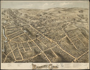
View of Danbury, Conn : 1875
11295.
View of Dedham, Mass. in 1876
11296.
View of East Boston, Mass : 1879
11297.
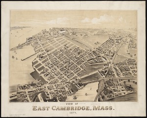
View of East Cambridge, Mass., 1879
11298.
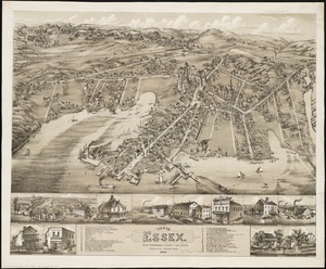
View of Essex, Centerbrook & Ivoryton, Conn : 1881
11299.
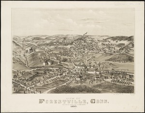
View of Forestville, Conn : 1880
11300.
View of Franklin, Mass : 1879
« Previous
Next »
1
2
…
109
110
111
112
113
114
115
116
117
Limit your search
Subject
Real property--Massachusetts--Boston--Maps
2,355
Boston (Mass.)--Maps
2,181
Landowners--Massachusetts--Boston--Maps
2,153
Roxbury (Boston, Mass.)--Maps
363
Dorchester (Boston, Mass.)--Maps
325
Cambridge (Mass.)--Maps
270
Brookline (Mass.)--Maps
237
Real property--Massachusetts--Cambridge--Maps
216
more
Subject
»
Place
North and Central America
8,975
United States
7,897
Massachusetts
5,088
Suffolk (county)
3,640
Boston
3,500
Europe
1,359
Middlesex (county)
622
Canada
448
more
Place
»
Format
Maps/Atlases
11,627
Manuscripts
215
Prints
56
Books
35
Objects/Artifacts
10
Drawings/Illustrations
8
Posters
4
Available to use
No known restrictions
11,484
Creative Commons license
68
Date
View distribution
Current results range from
1482
to
2023
Date range begin
Date range end
View larger »
Unknown
3
Collection
Norman B. Leventhal Map & Education Center Collection
11,413
Boston and New England Maps (Collection of Distinction)
5,303
Urban Maps (Collection of Distinction)
5,032
Maritime Charts and Atlases (Collection of Distinction)
1,081
American Revolutionary War-Era Maps (Collection of Distinction)
626
Boston Redevelopment Authority Collection
248
Historic Maps
49
Massachusetts Real Estate Atlases
38
more
Collection
»
Institution
Boston Public Library
11,552
State Library of Massachusetts
54
Salem State University Archives and Special Collections
49
Private Collection
21
American Antiquarian Society
9
Boston Athenaeum
1


![[Universal map of China]](https://bpldcassets.blob.core.windows.net/derivatives/images/commonwealth:qb98n8079/image_thumbnail_300.jpg)


![Vera-Cruz dans le Golfe du Méxique [and] Isle St. Juan, Fort de St. Jean d'Ulloa](https://bpldcassets.blob.core.windows.net/derivatives/images/commonwealth:cj82kx24p/image_thumbnail_300.jpg)