Skip to search
Skip to main content
Skip to first result
Digital Commonwealth
Folders
Sign Up / Log In
Search for
Search
Search
Search
Basic
Advanced
Explore
Map
Collections
Institutions
Formats
For Educators
Primary Source Sets
Lesson Plans
Using Primary Sources
Searching Digital Commonwealth
For Institutions
Join Digital Commonwealth
Conferences, Trainings, & Events
How to Contribute Collections
Digitization Services
Board & Committees
Frequently Asked Questions
About
About Digital Commonwealth
News & Announcements
Copyright & Terms of Use
Harmful Content Statement
Partners
API
Contact Us
Search
Search Constraints
Start Over
Save Search
Your search:
More Like
commonwealth:js956k42t
✖
Remove constraint More Like: commonwealth:js956k42t
« Prev.
|
11,301
-
11,319
of
11,319
| Next »
Sort
by date (asc)
relevance
title
date (asc)
date (desc)
Number of results to display per page
20
per page
per page
10
per page
20
per page
50
per page
100
per page
View results as:
List
list view
Maps
map view
Gallery
grid view
Search Results
11301.
Total foreign-born
11302.
A type-ology of population in Massachusetts
11303.
United States bee colonies
11304.
Western Massachusetts closed to the public
11305.
Western Massachusetts open space abounds
11306.
Tax parcels that would have been underwater in 1630
11307.
A city of unequal risks
11308.
A people's map of Lawrence, Massachusetts
11309.
A shared problem, an unequal burden : causes & consequences of climate change
11310.
Barton Street, West End
11311.
Boston's top 5 immigrant populations
11312.
East Boston flood risk
11313.
Fairbanks Street, Brighton
11314.
How we get around today
11315.
Oxford Street, Chinatown
11316.
Boston Harbor
11317.
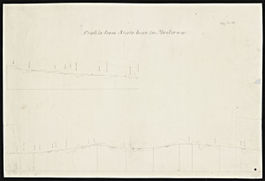
Map and profile of Charles River Railroad from Boston to Woonsocket
11318.
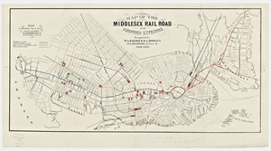
Map of the Middlesex railroad and proposed extension
11319.
[Railroad map of Eastern Massachusetts]
« Previous
Next »
1
2
…
562
563
564
565
566
Limit your search
Subject
Real property--Massachusetts--Boston--Maps
2,298
Boston (Mass.)--Maps
2,181
Landowners--Massachusetts--Boston--Maps
2,126
Roxbury (Boston, Mass.)--Maps
353
Dorchester (Boston, Mass.)--Maps
317
Massachusetts--Maps
271
Cambridge (Mass.)--Maps
268
Brookline (Mass.)--Maps
237
more
Subject
»
Place
North and Central America
8,133
United States
6,876
Suffolk (county)
3,552
Boston
3,412
Massachusetts
3,357
Europe
963
Middlesex (county)
619
Canada
428
more
Place
»
Format
Maps/Atlases
11,259
Manuscripts
217
Prints
51
Books
36
Objects/Artifacts
10
Drawings/Illustrations
8
Posters
4
Available to use
No known restrictions
11,072
Creative Commons license
70
Date
View distribution
Current results range from
1482
to
2023
Date range begin
Date range end
View larger »
Unknown
4
Collection
Norman B. Leventhal Map Center Collection
11,056
Boston and New England Maps (Collection of Distinction)
5,260
Urban Maps (Collection of Distinction)
4,966
Maritime Charts and Atlases (Collection of Distinction)
750
American Revolutionary War-Era Maps (Collection of Distinction)
632
Boston Redevelopment Authority Collection
193
Historic Maps
77
Mapping Boston Collection
22
more
Collection
»
Institution
Boston Public Library
11,140
Salem State University Archives and Special Collections
77
State Library of Massachusetts
56
Private Collection
22
American Antiquarian Society
13
Phillips Academy
8
Boston Athenaeum
1
Massachusetts Historical Society
1
more
Institution
»


![[Railroad map of Eastern Massachusetts]](https://bpldcassets.blob.core.windows.net/derivatives/metadata/commonwealth-oai:jd473c219/image_thumbnail_300.jpg)