Search


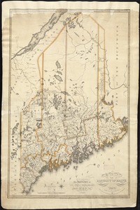
![Map of the disputed territory [Maine]](https://bpldcassets.blob.core.windows.net/derivatives/images/commonwealth:7h14b025h/image_thumbnail_300.jpg)
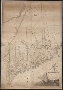


![[Map of the area along the Saint Croix River in Maine and New Brunswick]](https://bpldcassets.blob.core.windows.net/derivatives/images/commonwealth:6108vt00n/image_thumbnail_300.jpg)


Limit your search
- North and Central America8,687
- United States7,603
- Massachusetts4,955
- Suffolk (county)3,345
- Boston3,205
- Europe1,359
- Middlesex (county)618
- Canada447
Current results range from 1482 to 2023
- Norman B. Leventhal Map & Education Center Collection11,387
- Boston and New England Maps (Collection of Distinction)5,125
- Urban Maps (Collection of Distinction)4,857
- Maritime Charts and Atlases (Collection of Distinction)1,081
- American Revolutionary War-Era Maps (Collection of Distinction)624
- Boston Redevelopment Authority Collection87
- American Antiquarian Society Collection8
- Sidney R. Knafel Map Collection at Phillips Academy2