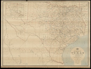
9521. Post route map of the state of Texas with adjacent parts of Louisiana, Arkansas, Indian Territory and of the Republic of Mexico showing post offices with the... Creator: United States. Post Office Dept Format: Maps/Atlases Collection: Norman B. Leventhal Map & Education Center Collection Date: 1891 Institution: Boston Public Library
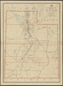
9522. Post route map of the state of Utah showing post offices with the intermediate distances on mail routes in operation on the 1st. of December, 1897 Creator: United States. Post Office Dept Format: Maps/Atlases Collection: Norman B. Leventhal Map & Education Center Collection Date: 1897 Institution: Boston Public Library
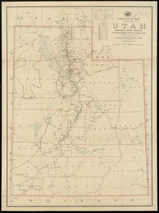
9523. Post route map of the state of Utah showing post offices with the intermediate distances on mail routes in operation on the 1st of December, 1903 Creator: United States. Post Office Dept Format: Maps/Atlases Collection: Norman B. Leventhal Map & Education Center Collection Date: 1903 Institution: Boston Public Library
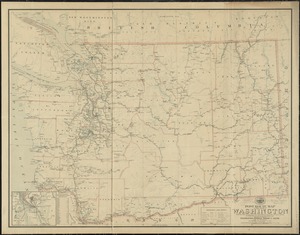
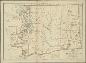
9524. Post route map of the state of Washington showing post offices with the intermediate distances and mail routes in operation on the 1st of December, 1903 Creator: United States. Post Office Dept Format: Maps/Atlases Collection: Norman B. Leventhal Map & Education Center Collection Date: 1903 Institution: Boston Public Library
9525. Post route map of the state of Washington showing post offices with the intermediate distances on mail routes in operation on the 1st. of September, 1897 Creator: United States. Post Office Dept Format: Maps/Atlases Collection: Norman B. Leventhal Map & Education Center Collection Date: 1897 Institution: Boston Public Library
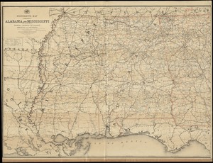
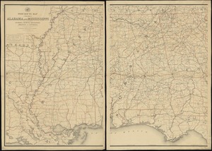
9526. Post route map of the states of Alabama and Mississippi with adjacent parts of Florida, Georgia, Tennessee, Arkansas and Louisiana : showing post offices with the... Creator: United States. Post Office Dept Format: Maps/Atlases Collection: Norman B. Leventhal Map & Education Center Collection Date: 1891 Institution: Boston Public Library
9527. Post route map of the states of Alabama and Mississippi with adjacent parts of Florida, Georgia, Tennessee, Arkansas and Louisiana : showing post offices, with the... Creator: United States. Post Office Dept Format: Maps/Atlases Collection: Norman B. Leventhal Map & Education Center Collection Date: 1883 Institution: Boston Public Library
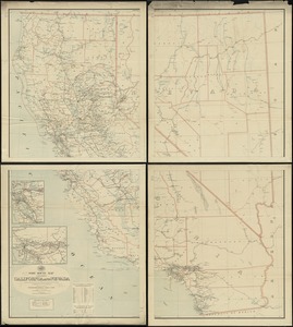
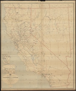
9528. Post route map of the states of California and Nevada showing post offices with the intermediate distances on mail routes in operation on the 1st of December, 1897 Creator: United States. Post Office Dept Format: Maps/Atlases Collection: Norman B. Leventhal Map & Education Center Collection Date: 1897 Institution: Boston Public Library
9529. Post route map of the states of California and Nevada showing post offices with the intermediate distances on mail routes in operation on the 1st of December, 1903 Creator: United States. Post Office Dept Format: Maps/Atlases Collection: Norman B. Leventhal Map & Education Center Collection Date: 1903 Institution: Boston Public Library
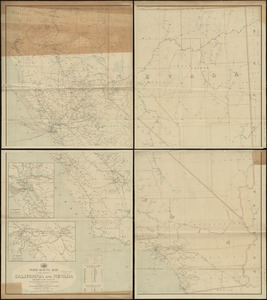
9530. Post route map of the states of California and Nevada with adjacent parts of Oregon, Idaho, Utah, Arizona and of the Republic of Mexico : showing post offices with the... Creator: United States. Post Office Dept Format: Maps/Atlases Collection: Norman B. Leventhal Map & Education Center Collection Date: [1889] Institution: Boston Public Library
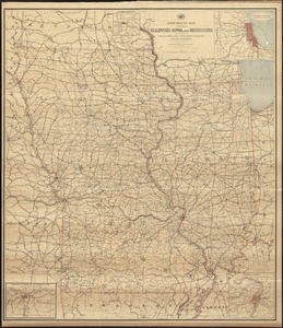
9531. Post route map of the states of Illinois, Iowa, and Missouri with adjacent parts of Indiana, Wisconsin, Minnesota, Nebraska, Kansas and Arkansas showing post offices... Creator: United States. Post Office Dept Format: Maps/Atlases Collection: Norman B. Leventhal Map & Education Center Collection Date: 1891 Institution: Boston Public Library
9532. Post route map of the states of Kansas and Nebraska showing post offices with the intermediate distances and mail routes in operation on the 1st. of December, 1895 Creator: United States. Post Office Dept Format: Maps/Atlases Collection: Norman B. Leventhal Map & Education Center Collection Date: 1895 Institution: Boston Public Library
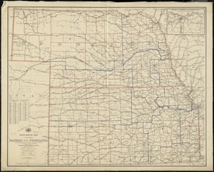
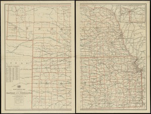
9533. Post route map of the states of Kansas and Nebraska showing post offices with the intermediate distances on mail routes in operation on the 1st. of December, 1897 Creator: United States. Post Office Dept Format: Maps/Atlases Collection: Norman B. Leventhal Map & Education Center Collection Date: 1897 Institution: Boston Public Library
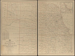
9534. Post route map of the states of Kansas and Nebraska showing post offices with the intermediate distances on mail routes in operation on the 1st of December, 1903 Creator: United States. Post Office Department; Von Haake, A. Format: Maps/Atlases Collection: Norman B. Leventhal Map & Education Center Collection Date: 1903 Institution: Boston Public Library
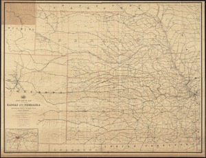
9535. Post route map of the states of Kansas and Nebraska with adjacent parts of Missouri, Iowa, Dakota, Colorado, Texas, and Indian Territory showing post offices with the... Creator: United States. Post Office Dept Format: Maps/Atlases Collection: Norman B. Leventhal Map & Education Center Collection Date: 1891 Institution: Boston Public Library
9536. Post route map of the states of Kentucky and Tennessee showing post offices and intermediate distances on mail routes in operation September 1st. 1897 Creator: United States. Post Office Dept Format: Maps/Atlases Collection: Norman B. Leventhal Map & Education Center Collection Date: 1897 Institution: Boston Public Library
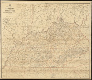
9537. Post route map of the states of Kentucky and Tennessee showing post offices with the intermediate distances and mail routes in operation on the 1st of December, 1903 Creator: United States. Post Office Department; Von Haake, A. Format: Maps/Atlases Collection: Norman B. Leventhal Map & Education Center Collection Date: 1903 Institution: Boston Public Library
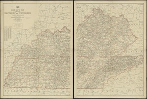
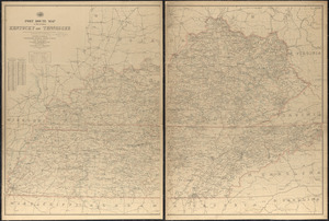
9538. Post route map of the states of Kentucky and Tennessee with adjacent parts of Va., West Va., Ohio, Ind., Ill., Mo., Ark., Miss., Ala., Ga., S.C., N.C., showing post... Creator: United States. Post Office Dept Format: Maps/Atlases Collection: Norman B. Leventhal Map & Education Center Collection Date: 1891 Institution: Boston Public Library
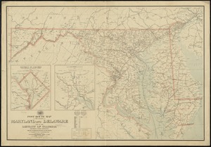
9539. Post route map of the states of Maryland and Delaware and of the District of Columbia showing post offices with the intermediate distances on mail routes in operation... Creator: United States. Post Office Dept Format: Maps/Atlases Collection: Norman B. Leventhal Map & Education Center Collection Date: 1903 Institution: Boston Public Library
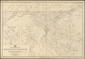
9540. Post route map of the states of Maryland and Delaware and of the District of Columbia showing post offices with the intermediate distances on mail routes in operation... Creator: United States. Post Office Dept Format: Maps/Atlases Collection: Norman B. Leventhal Map & Education Center Collection Date: 1897 Institution: Boston Public Library