Skip to search
Skip to main content
Skip to first result
Digital Commonwealth
Folders
Sign Up / Log In
Search for
Search
Search
Search
Basic
Advanced
Explore
Map
Collections
Institutions
Formats
For Educators
Primary Source Sets
Lesson Plans
Using Primary Sources
Searching Digital Commonwealth
For Institutions
Join Digital Commonwealth
Conferences, Trainings, & Events
How to Contribute Collections
Digitization Services
Board & Committees
Frequently Asked Questions
About
About Digital Commonwealth
News & Announcements
Copyright & Terms of Use
Harmful Content Statement
Partners
API
Contact Us
Search
Search Constraints
Start Over
Save Search
Your search:
More Like
commonwealth:1z40pb40v
✖
Remove constraint More Like: commonwealth:1z40pb40v
« Prev.
|
11,301
-
11,350
of
11,739
|
Next »
Sort
by relevance
relevance
title
date (asc)
date (desc)
Number of results to display per page
50
per page
per page
10
per page
20
per page
50
per page
100
per page
View results as:
List
list view
Maps
map view
Gallery
grid view
Search Results
11301.
Die Vereinigten Staaten von Nord-America : nach den sichersten Bestimmungen, neuesten Nachrichten und Charten, in der...
11302.
Verkehrs-karte von Europa : übersichts grösserer eisenbahnverbindungen, telegraphen und überseeischer dampfschiffahrt
11303.
Vermont
11304.
Vermont
11305.
Vermont, from actual survey : with all the late additions & improvements
11306.
Vermont from actual survey
11307.
Vermont from actual survey
11308.
Vernon County, Wis.
11309.
Veromandui le Vermandois : Evesché de Noyon ou sont les Comté et Pairrie de Noyon : Balliages et Prevostés de Noyon, Chauny,...
11310.
Veromanduorum eorum que confinium exactissima descriptio
11311.
Vertical sections to accompany the geological map of the Boulder Belt, East Coolgardie, G.F.
11312.
Vesconte de Maiollo conposuy hanc cartan in Janua anno dñy. 1587. die xx. Decenbris
11313.
Vestigie di Roma antica per gli annali della stessa città
11314.
Via RCA : a direct marine radio service to and from ships at sea
11315.
Viaggio ai tre laghi Maggiore, di Lugano e di Como al Monte Rosa, al Sempione ed al Sacro Monte di Varallo
11316.
Vicksburg and its defences : constructed and engraved to illustrate "The war with the South"
11317.
Victoria
11318.
Victoria
11319.
Victory map
11320.
Victory map 1919
11321.
The victory war map
11322.
Viennense territorium ob res bellicas inter Christianos et Turcas nuperrime editum
11323.
Vieux Paris et ses monuments (XVIIe siècle) : avec le tracé de ses limites sous Philippe-Auguste, Charles VI, Louis XII et...
11324.
A view from the south eastward of Halifax Harbor : Appearance of the shore, (at three miles off,) four or five leagues to the...
11325.
View of Amherst, Mass
11326.
View of Andover, Massachusetts : 1882
11327.
View of Ansonia, Conn : 1875
11328.
View of Ashland, Mass : 1878
11329.
View of Athol, Mass : 1878
11330.
View of Attleborough, Mass : East Village, 1878
11331.
View of Bethel, Conn
11332.
View of Beverly, Mass
11333.
A view of Boston
11334.
View of Boston freight terminals, the New York, New Haven & Hartford Railroad
11335.
View of Boston, July 4th 1870
11336.
A view of Boston taken on the road to Dorchester
11337.
View of Bristol, Conn
11338.
View of Canton, Mass : 1878
11339.
View of Cape Egmont and winter Rock from the eastward : Entrance of Egmont Harbor ; The entrance of Keppel Harbor, 10 leagues...
11340.
View of Chatham : New Brunswick
11341.
View of Cheshire, Connecticut : 1882
11342.
View of Chester, Connecticut : 1881
11343.
View of Clinton, Connecticut : 1881
11344.
View of College Point, L.I : 1876
11345.
View of Collinsville, Conn : 1878
11346.
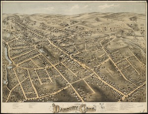
View of Danbury, Conn : 1875
11347.
View of Dedham, Mass. in 1876
11348.
View of East Boston, Mass : 1879
11349.
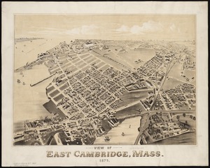
View of East Cambridge, Mass., 1879
11350.
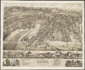
View of Essex, Centerbrook & Ivoryton, Conn : 1881
« Previous
Next »
1
2
…
223
224
225
226
227
228
229
230
231
…
234
235
Limit your search
Subject
Real property--Massachusetts--Boston--Maps
2,319
Landowners--Massachusetts--Boston--Maps
2,119
Boston (Mass.)--Maps
2,060
City planning--Massachusetts--Boston--Maps
417
Roxbury (Boston, Mass.)--Maps
389
Dorchester (Boston, Mass.)--Maps
322
Cambridge (Mass.)--Maps
266
Urban renewal--Massachusetts--Boston--Maps
252
more
Subject
»
Place
North and Central America
9,028
United States
7,952
Massachusetts
5,024
Suffolk (county)
3,697
Boston
3,557
Europe
1,359
Middlesex (county)
619
Canada
448
more
Place
»
Format
Maps/Atlases
11,680
Manuscripts
215
Prints
56
Books
35
Objects/Artifacts
10
Drawings/Illustrations
8
Posters
4
Available to use
No known restrictions
11,671
Creative Commons license
46
Date
View distribution
Current results range from
1482
to
2023
Date range begin
Date range end
View larger »
Collection
Norman B. Leventhal Map & Education Center Collection
11,386
Boston and New England Maps (Collection of Distinction)
5,477
Urban Maps (Collection of Distinction)
5,207
Maritime Charts and Atlases (Collection of Distinction)
1,081
American Revolutionary War-Era Maps (Collection of Distinction)
615
Boston Redevelopment Authority Collection
439
Institution
Boston Public Library
11,739