Skip to search
Skip to main content
Skip to first result
Digital Commonwealth
Folders
Sign Up / Log In
Search for
Search
Search
Search
Basic
Advanced
Explore
Map
Collections
Institutions
Formats
For Educators
Primary Source Sets
Lesson Plans
Using Primary Sources
Searching Digital Commonwealth
For Institutions
Join Digital Commonwealth
Conferences, Trainings, & Events
How to Contribute Collections
Digitization Services
Board & Committees
Frequently Asked Questions
About
About Digital Commonwealth
News & Announcements
Copyright & Terms of Use
Harmful Content Statement
Partners
API
Contact Us
Search
Search Constraints
Start Over
Save Search
Your search:
More Like
commonwealth:1831hz45r
✖
Remove constraint More Like: commonwealth:1831hz45r
« Prev. |
1
-
20
of
202
|
Next »
Sort
by relevance
relevance
title
date (asc)
date (desc)
Number of results to display per page
20
per page
per page
10
per page
20
per page
50
per page
100
per page
View results as:
List
list view
Maps
map view
Gallery
grid view
Search Results
1.
The regional open space system : [Boston, Massachusetts metropolitan area]
2.
Infrastructure around Tobin Bridge/US route 1 in Charlestown
3.
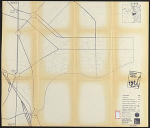
South Boston urban renewal area r-51 : proposed circulation
4.
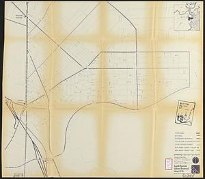
South Boston urban renewal area r-51 : existing circulation
5.
Major thoroughfare system, city of Boston, June 1972
6.
The 1976 proposed regional open space plan
7.
Boston's bikemap : Arlington, Belmont, Brookline, Cambridge, Chelsea, Everett, Lexington, Malden, Medford, Needham, Newton,...
8.
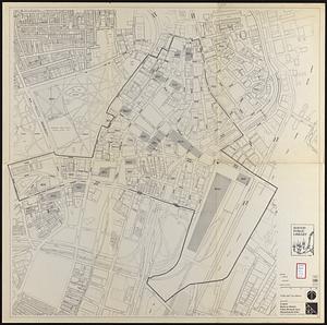
Charlestown urban renewal area, Massachusetts R-55 : illustrative site plan
9.
Development of the Calfpasture, Boston, Massachusetts
10.
Downtown Boston
11.
Fenway urban renewal area, Massachusetts R-115 : illustrative site plan
12.
Hancock Woods : as of right plan
13.
Boston traffic map showing one way streets and parking spaces
14.
Central business district urban renewal area Massachusetts r-82 : vehicular circulation
15.
Disposition parcels, Charlestown urban renewal area, Massachusetts R-55
16.
Government Center project no. Mass. r-35 : proposed land use map
17.
Herald Street improvements
18.
Park Plaza traffic improvements & grade level controls
19.
Proposed land use plan and circulation system
20.
Recommended geometrics plan : Back Bay study area
« Previous
Next »
1
2
3
4
5
…
10
11
Limit your search
Subject
Boston (Mass.)--Maps
72
Local transit--Massachusetts--Boston--Maps
59
Boston Metropolitan Area (Mass.)--Maps
25
Subways--Massachusetts--Boston--Maps
25
City planning--Massachusetts--Boston--Maps
24
Boston Elevated Railway Company
21
Massachusetts--Maps
20
Roads--Massachusetts--Boston--Maps
15
more
Subject
»
Place
North and Central America
187
United States
185
Boston
112
Suffolk (county)
112
Massachusetts
60
Virginia
13
Charlestown
5
Connecticut
5
more
Place
»
Format
Maps/Atlases
199
Ephemera
2
Documents
1
Posters
1
Available to use
No known restrictions
191
Creative Commons license
5
Date
View distribution
Current results range from
1855
to
2023
Date range begin
Date range end
View larger »
Collection
Norman B. Leventhal Map Center Collection
171
Boston and New England Maps (Collection of Distinction)
112
David Judkins Weaver Papers
96
Urban Maps (Collection of Distinction)
44
Boston Redevelopment Authority Collection
31
Historic Maps
3
Mapping Boston Collection
2
Massachusetts Department of Transportation
2
Institution
Boston Public Library
195
Salem State University Archives and Special Collections
3
Private Collection
2
State Library of Massachusetts
2