Skip to search
Skip to main content
Skip to first result
Digital Commonwealth
Folders
Sign Up / Log In
Search for
Search
Search
Search
Basic
Advanced
Explore
Map
Collections
Institutions
Formats
For Educators
Primary Source Sets
Lesson Plans
Using Primary Sources
Searching Digital Commonwealth
For Institutions
Join Digital Commonwealth
Conferences, Trainings, & Events
How to Contribute Collections
Digitization Services
Board & Committees
Frequently Asked Questions
About
About Digital Commonwealth
News & Announcements
Copyright & Terms of Use
Harmful Content Statement
Partners
API
Contact Us
Search
« Prev.
|
1,223,601
-
1,223,700
of
1,236,902
|
Next »
Sort
by relevance
relevance
title
date (asc)
date (desc)
Number of results to display per page
100
per page
per page
10
per page
20
per page
50
per page
100
per page
View results as:
List
list view
Maps
map view
Gallery
grid view
Search Results
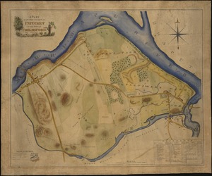
1223601.
Survey of a valley and ponds auxiliary to a contemplated canal between Buzzard's & Barnstable Bays, state of Massachusetts and...
1223602.
Survey across the isthmus of Cape Cod, state of Massachusetts and town of Sandwich of a proposed canal between Buzzard's and...
1223603.
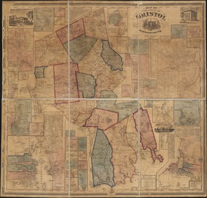
Map of the county of Bristol, Massachusetts : based upon the trigonometrical survey of the state
1223604.
Two miles around the pendulum station on Hoosac Mountain near central shaft of tunnel, Massachusetts, 1874
1223605.
[Map of Berkshire County]
1223606.
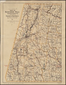
Map of the Berkshire Hills Massachusetts
1223607.
A map of Berkshire County Mass
1223608.
Map of the roads of Wellesley and vicinity
1223609.
Map of the eastern junc. Broad Sound Pier, & Pt. Shirley railroad : steamboat lines and connections : established for the...
1223610.
Chart of Boston Harbor and Massachusetts Bay : with map of the adjacent country
1223611.
Map showing drives from the Walker-Gordon Laboratory, 203 Claredon St., Boston, to the Laboratory Farm in Wellesley
1223612.
Balloon view Provincetown to Boston
1223613.
The North Shore and part of Middlesex County, Mass
1223614.
[Map of Boston and vicinity]
1223615.
The South Shore and Norfolk County, Mass
1223616.
Map of Boston and the country adjacent, from actual surveys
1223617.
Hazleton : Pennsylvania
1223618.
Bird's-eye view of the Conemaugh Valley, from Nineveh to the Lake : Johnstown, Pa., from personal sketches and surveys of the...
1223619.
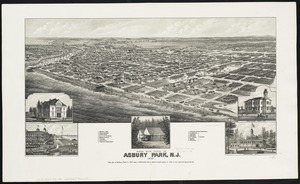
Bird's eye view of Asbury Park, N.J
1223620.
Blairstown, New Jersey
1223621.
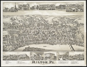
Milton, Pa
1223622.
Flemington : New Jersey
1223623.
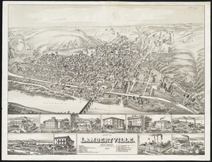
View of Lambertville, New Jersey
1223624.
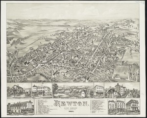
Newton : New Jersey
1223625.
East Stroudsburg : Pennsylvania
1223626.
Geological map of Essex County, Massachusetts
1223627.
A new and accurate map of the province of New York and part of the Jerseys, New England and Canada, shewing the scenes of our...
1223628.
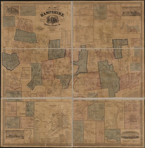
Map of the county of Hampshire, Massachusetts : based upon the trigonometrical survey of the state
1223629.
Plan showing proposed method of introducing the water of Mystic Pond into Charlestown
1223630.
Views of London in 1616 and 1890
1223631.
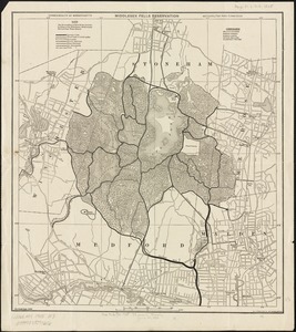
Middlesex Fells Reservation
1223632.
Edinburgh in 1886
1223633.
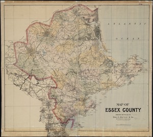
Map of Essex County
1223634.
Plan of Middlesex County, Massachusetts
1223635.
The South Cove territory, comprising every part which is coloured on this map
1223636.
A new & complete map of the city of Boston, with part of Charlestown, Cambridge & Roxbury
1223637.
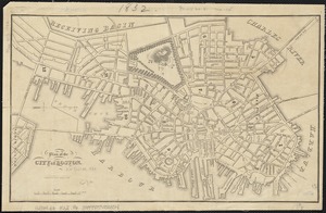
Boston, 1838
1223638.
A new & complete map of the city of Boston, with part of Charlestown, Cambridge & Roxbury
1223639.
Plan of Boston comprising a part of Charlestown and Cambridge
1223640.
Plan of Boston with parts of the adjacent towns
1223641.
A new & complete map of the city of Boston, with part of Charlestown, Cambridge & Roxbury
1223642.
Plan of Boston comprising a part of Charlestown and Cambridge
1223643.
Plan of Boston with parts of the adjacent towns
1223644.
New map of Boston, comprising the whole city, with the new boundaries of the wards
1223645.
Peremptory sale : this valuable property will positively be sold at public auction on Saturday the 29th day of April current at...
1223646.
Plan of the city of Boston
1223647.
Plan of building lots on Washington, Waltham & Parker Streets and Harrison Avenue, belonging to the Boston Lying-In Hospital...
1223648.
Plan of the Hutchinson Estate on the corner of Hanover & Clark Streets : to be sold by public auction on Monday Feby. 20th 1871...
1223649.
Plan of real estate on Cambridge Street near Bowdoin Square, belonging to the heirs of the late Deacon Moses : to be sold by...
1223650.
Plan of estate, nos 1043 to 1059 Washington Street, Boston, belonging to the heirs of the late William Brigham : to be sold by...
1223651.
Plan of the estate on the southerly corner of Washington and Franklin Streets : to be sold by public auction on Saturday June...
1223652.
Plan of the Coffin Estate, corner of Summer and Chauncy Streets : to be sold by public auction on Wednesday April 26th 1856 at...
1223653.
Plan of the estates nos. 246 to 252 Congress corner of Purchase Street and nos. 59 to 69 Purchase Street : to be sold by public...
1223654.
Plan of land on Bedford and Avon Streets belonging to the proprietors of the Second Church in Boston : to be sold by public...
1223655.
Plan of an estate in High St. to be sold at auction Sat. May 1st 1847 at 12 o'clock on the premises by Whitwell, Seaver & Co....
1223656.
A sketch of the environs of Charlestown in South Carolina
1223657.
Plan der landung der Gebrüdere Howe, bey dem ausfluss des Elk Strom ...Lords Cornwallis
1223658.
A rough and inaccurate sketch of the streets of Boston as they are supposed to have been first laid out & the owners of the...
1223659.
[Plan of real estate on Pearl Street, Boston]
1223660.
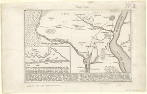
[Plan of engagement with British ships near Red Bank, New Jersey, October 22 and 23, 1777]
1223661.
Plan of Charles River and Warren bridges, with the vicinity
1223662.
[Map of the end of Boston Wharf from which restrictions are to be taken off]
1223663.
Plan of the South Cove
1223664.
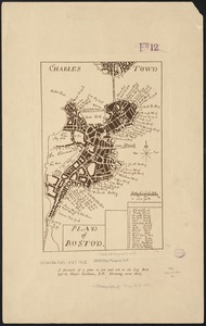
Plan of Boston
1223665.
Lynn, Mass [art original] : west view from near High Rock
1223666.
A plan of sundry farms etc. at Patucket in the town of Chelmsford
1223667.
Boston Harbor, Massachusetts
1223668.
Karte von Neu England, Neu Yorck und Pensilvanien : sur Allgemeinen historie der reisen
1223669.
Nieuwe kaart van de Grootbrittannische volkplantingen in Noord America : waar in tevens de Fransche bezittingen en de Landen,...
1223670.
Bird's eye view of Portsmouth, Rockingham Co., New Hampshire
1223671.
[Plan of Boston neck]
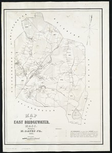
1223672.
Map of East Bridgewater, Mass
1223673.
Birds-eye view of Boston and vicinity : showing the outlying towns and villages and railroad communications
1223674.
Plan of land & wharves belonging to Mill Pond Wharf Co. near Bartons Point
1223675.
Plan of City Wharf in Boston, Mass : shewing 14 lots of land on the side of the south dock of said wharf & Commercial St. : to...
1223676.
Plan of the Federal St. Meeting House estate : to be sold by public auction, on Thursday February 24th 1859, at 12 o'clock noon...
1223677.
Plan of Mercantile Wharf property in Boston Mass : showing 5 lots of land thereon to be sold at public auction on Tuesday April...
1223678.
[Plan of lots on Beacon Street and Somerset Court, Boston]
1223679.
Plan of Quincy House lot, corner of Brattle St. and Brattle Sq. belonging to the estate of Josiah Quincy Jr : to be sold by...
1223680.
Real estate on Milk & Oliver Sts. belonging to the Boston Mang. Co. & Merrimack Mang. Co. to be sold on Friday, March 15th 1844...
1223681.
Plan of the estate of the late Joseph Head Esq. to be sold at auction, Oct. 8th 1841
1223682.
Plan of the Pratt estate, corner of Summer & Hawley Streets : to be sold by pulic auction on Thursday April 10th 1855 at 12...
1223683.
Vineyard Sound and Buzzards Bay, Massachusetts
1223684.
Vicksburg and its defences : constructed and engraved to illustrate "The war with the South"
1223685.
Antietam Sharpsburg and vicinity : constructed and engraved to illustrate "The war with the South"
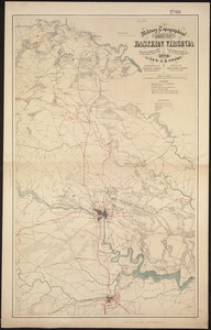
1223686.
Military topographical map of eastern Virginia showing the routes taken by the several army corps & the battles fought in the...
1223687.
[Plan showing wharves of Boston from Batterymarch Street to Fleet Street; the "circular line" limit of wharves; and the...
1223688.
[Plan showing wharves of Boston from Batterymarch Street to Fleet Street; the "circular line" limit of wharves; and the...
1223689.
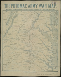
The Potomac army war map : designed to show the present fighting ground in Virginia to meet the demand of the times
1223690.
Proposed street railroad over the Back Bay to Brookline
1223691.
A map of North America, with the European settlements & whatever else is remarkable in ye West Indies, from the latest and best...
1223692.
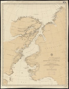
North America polar regions : Baffin Bay to Lincoln Sea, showing the most recent discoveries including those of U.S.S. Polaris...
1223693.
New Jersey showing forest area and its relation to the principal watersheds
1223694.
Rand McNally & Co's new railroad and county map of the United States and Dominion of Canada
1223695.
Rand, McNally & Co.'s new sectional map of Kansas
1223696.
The Rand McNally new commercial atlas map of South Carolina
1223697.
J.M.E. Riedel's new street number guide map of Fort Wayne
1223698.
Plan of lots on Fort Hill district, belonging to the City of Boston : to be sold at public auction, on Wednesday, April 15th at...
1223699.
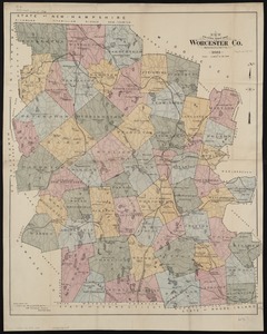
New driving road map of Worcester Co. Massachusetts
1223700.
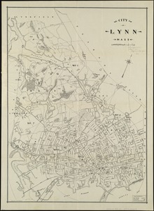
City of Lynn, Mass
« Previous
Next »
1
2
…
12,233
12,234
12,235
12,236
12,237
12,238
12,239
12,240
12,241
…
12,369
12,370
Limit your search
Subject
Houses
26,811
waterworks
19,972
Buildings
18,149
Students
15,739
Antislavery movements--United States
13,111
News
12,448
Antislavery movements--United States--History--19th century
11,293
reservoirs (water distribution structures)
11,160
more
Subject
»
Place
North and Central America
625,385
United States
621,058
Massachusetts
527,024
Suffolk (county)
216,094
Boston
210,978
Essex (county)
64,578
Middlesex (county)
54,679
Worcester (county)
51,776
more
Place
»
Format
Photographs
506,287
Manuscripts
228,395
Letters/Correspondence
185,353
Newspapers
110,255
Documents
101,577
Postcards/Cards
62,347
Film/Video
57,967
Prints
50,698
more
Format
»
Available to use
No known restrictions
266,985
Creative Commons license
162,201
Date
View distribution
Current results range from
-8000
to
2873
Date range begin
Date range end
View larger »
Unknown
79,442
Collection
W. E. B. Du Bois Papers, 1803-1999 (bulk 1877-1963)
99,739
American Archive of Public Broadcasting Collection
85,165
Newspapers from the Boston Public Library
67,875
Mark H. McCormack Papers, ca. 1920-2008 (bulk: 1957-2003)
48,824
Digitized Museum Collections
45,842
Tewksbury Almshouse Intake Records [1854-1884]
41,668
Leslie Jones Collection
37,421
Tichnor Brothers Postcard Collection
28,068
more
Collection
»
Institution
Boston Public Library
320,681
Special Collections and University Archives, University of Massachusetts Amherst Libraries
239,006
Historic New England
105,261
Northeastern University Library
68,545
Public Health Museum in Massachusetts
41,668
Massachusetts Archives
27,189
Springfield College Archives and Special Collections
22,438
Newburyport Public Library
18,961
more
Institution
»


![[Map of Berkshire County]](https://bpldcassets.blob.core.windows.net/derivatives/images/commonwealth:wd376641h/image_thumbnail_300.jpg)


![[Map of Boston and vicinity]](https://bpldcassets.blob.core.windows.net/derivatives/images/commonwealth:wd376691q/image_thumbnail_300.jpg)


![[Plan of real estate on Pearl Street, Boston]](https://bpldcassets.blob.core.windows.net/derivatives/images/commonwealth:9s161d705/image_thumbnail_300.jpg)
![[Plan of engagement with British ships near Red Bank, New Jersey, October 22 and 23, 1777]](https://bpldcassets.blob.core.windows.net/derivatives/images/commonwealth:9s161d76t/image_thumbnail_300.jpg)

![[Map of the end of Boston Wharf from which restrictions are to be taken off]](https://bpldcassets.blob.core.windows.net/derivatives/images/commonwealth:9s161d66k/image_thumbnail_300.jpg)

![Lynn, Mass [art original]](https://bpldcassets.blob.core.windows.net/derivatives/images/commonwealth:9s161g34q/image_thumbnail_300.jpg)


![[Plan of Boston neck]](https://bpldcassets.blob.core.windows.net/derivatives/images/commonwealth:9s161g52n/image_thumbnail_300.jpg)


![[Plan of lots on Beacon Street and Somerset Court, Boston]](https://bpldcassets.blob.core.windows.net/derivatives/images/commonwealth:9s161h18j/image_thumbnail_300.jpg)


![[Plan showing wharves of Boston from Batterymarch Street to Fleet Street; the "circular line" limit of wharves; and the Barricado, with gaps]](https://bpldcassets.blob.core.windows.net/derivatives/images/commonwealth:9s161j18r/image_thumbnail_300.jpg)
![[Plan showing wharves of Boston from Batterymarch Street to Fleet Street; the "circular line" limit of wharves; and the Barricado, with gaps]](https://bpldcassets.blob.core.windows.net/derivatives/images/commonwealth:9s161j166/image_thumbnail_300.jpg)