Skip to search
Skip to main content
Digital Commonwealth
Sign Up / Log In
Search for
Search
Search
Search
Basic
Advanced
Explore
Map
Collections
Institutions
Formats
For Educators
Primary Source Sets
Lesson Plans
Using Primary Sources
Searching Digital Commonwealth
For Institutions
Join Digital Commonwealth
Conferences, Trainings, & Events
How to Contribute Collections
Digitization Services
Board & Committees
Frequently Asked Questions
About
About Digital Commonwealth
News & Announcements
Copyright & Terms of Use
Harmful Content Statement
Partners
API
Contact Us
American Antiquarian Society
American Revolutionary War-Era Maps (Collection of Distinction)
/
American Antiquarian Society Collection
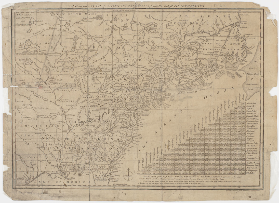
A General map of North America; : from the latest observations
A General map of North America;
×
Item Information
Title:
A General map of North America; : from the latest observations
Title (uniform):
North-American and West-Indian gazetteer
Description:
Subject: Map of the United States and Canada west to Louisiana. Includes a table of distances between towns and forts in North America.
Name on Item:
Engrav'd by Jno. Lodge, from the late Mr. Jefferys geographer to the King.
Date:
[1778]
Format:
Maps/Atlases
Location:
American Antiquarian Society
Collection (local):
American Antiquarian Society Collection
Subjects:
United States--Maps
Canada--Maps
Places:
United States
Canada
Extent:
1 map : engraving ; 28 x 39 cm., on sheet 31 x 42 cm.
Permalink:
https://ark.digitalcommonwealth.org/ark:/50959/z603vg96t
Terms of Use:
Public Domain/No known restrictions on use. Contact host institution to download image.
Contact host institution for more information.
Publisher:
London : [s.n.]
Scale:
Scale [ca. 1:10,500,000]
Language:
English
Referenced by:
http://catalog.mwa.org/vwebv/holdingsInfo?bibId=489836
Notes:
Relief shown by hachures.
"Distances of the most noted towns, forts &c. in North America ... "
From the North-American and West-Indian gazetteer, London, 1778.
Notes (date):
This date is inferred.
show more...
View MODS XML
More Like This
America Septentrionalis : a Domino d'Anville in Galliis edita nune ...
The British governments in Nth. America : laid down agreeable to ...
Carte des pays connus sous le nom de Canada, : dans laquelle sont ...
Karte von den seen in Canada
Find More Like This >>
Tools
Share
Facebook
Pinterest
X
Reddit
Tumblr
Email
Copy link
Add to Folder
Questions/Comments
Cite This Item
IIIF Manifest
We'd love your feedback!
×
Would you be interested in taking a short survey about Digital Commonwealth?