Skip to search
Skip to main content
Digital Commonwealth
Sign Up / Log In
Search for
Search
Search
Search
Basic
Advanced
Explore
Map
Collections
Institutions
Formats
For Educators
Primary Source Sets
Lesson Plans
Using Primary Sources
Searching Digital Commonwealth
For Institutions
Join Digital Commonwealth
Conferences, Trainings, & Events
How to Contribute Collections
Digitization Services
Board & Committees
Frequently Asked Questions
About
About Digital Commonwealth
News & Announcements
Copyright & Terms of Use
Harmful Content Statement
Partners
API
Contact Us
American Antiquarian Society
American Revolutionary War-Era Maps (Collection of Distinction)
/
American Antiquarian Society Collection
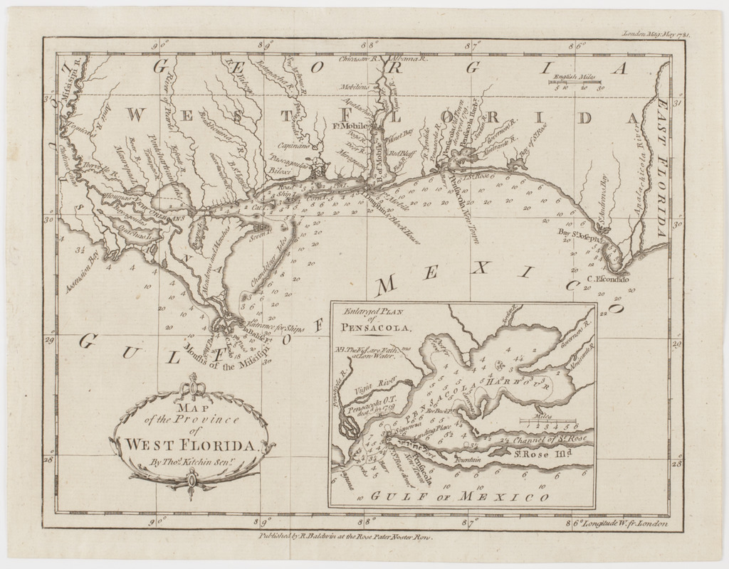
Map of the province of West Florida
Map of the province of West Florida
×
Item Information
Title:
Map of the province of West Florida
Title (uniform):
London magazine
Description:
Subject: Map of the panhandle of Florida, reaching from the Mississippi River to the Apalachicola River. Includes an inset of Pensacola harbor.
Creator:
Kitchin, Thomas, 1718-1784
Publisher:
Baldwin, R. (Robert), 1737-1810
Name on Item:
By Thos. Kitchin Senr.
Date:
[1781]
Format:
Maps/Atlases
Location:
American Antiquarian Society
Collection (local):
American Antiquarian Society Collection
Subjects:
Florida--Maps
Pensacola (Fla.)--Maps
Places:
Escambia (county)
>
Pensacola
Extent:
1 map : engraving ; 19 x 24 cm., on sheet 21 x 27 cm.
Permalink:
https://ark.digitalcommonwealth.org/ark:/50959/z603vg20g
Terms of Use:
Public Domain/No known restrictions on use. Contact host institution to download image.
Contact host institution for more information.
Publisher:
[London] : Published by R. Baldwin at the Rose Pater Noster Row.
Scale:
Scale [ca. 1:2,534,000]
Language:
English
Referenced by:
http://catalog.mwa.org/vwebv/holdingsInfo?bibId=486371
Notes:
Depths shown by soundings.
"London mag. May 1781."
Inset: Enlarged plan of Pensacola.
Notes (date):
This date is inferred.
show more...
View MODS XML
More Like This
A Map of the new governments, of East & West Florida
Carte de la Floride, de la Louisiane, et pays voisins. : Pour ...
Carte de la Louisiane et de la Floride
Florida from the latest authorities
Find More Like This >>
Tools
Share
Facebook
Pinterest
X
Reddit
Tumblr
Email
Copy link
Add to Folder
Questions/Comments
Cite This Item
IIIF Manifest