Forest Damage from the 1938 Hurricane by Towns
Item Information
- Title:
- Forest Damage from the 1938 Hurricane by Towns
- Description:
-
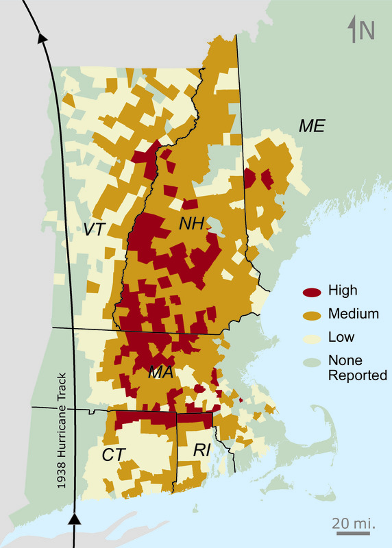
Forest damage from the 1938 hurricane. Greater wind speeds and forest damage occurred on the right side of the track due to its rapid forward movement and counter-clockwise rotation. Connecticut and Rhode Island display less damage than northern states due to less forest cover and less white pine, which is highly susceptible to blow-down. Damage is represented by the volume of timber windblown by town: (none), no damage or data; (low), <1 million board feet; (medium), 1-10 million board feet; and (high), >10 million board feet. One board foot equals a board one foot square and one inch thick. Hurricane track data from Emery Boose and the Harvard Forest.
- Name on Item:
-
Brian R. Hall [Compiler]
- Date:
-
August 7, 2015
- Format:
-
Maps/Atlases
Objects/Artifacts
- Genre:
-
Book illustrations
- Location:
-
Harvard University
Harvard Forest Archives - Collection (local):
-
Harvard Forest Martha's Vineyard Collection
- Subjects:
-
Coastal
Regional Studies
Hurricanes
- Places:
-
New England (area)
- Permalink:
- https://ark.digitalcommonwealth.org/ark:/50959/vh53xt39n
- Terms of Use:
-
Copyright (c) Brian R. Hall
This work is licensed for use under a Creative Commons Attribution Non-Commercial No Derivatives License (CC BY-NC-ND).