Skip to search
Skip to main content
Digital Commonwealth
Sign Up / Log In
Search for
Search
Search
Search
Basic
Advanced
Explore
Map
Collections
Institutions
Formats
For Educators
Primary Source Sets
Lesson Plans
Using Primary Sources
Searching Digital Commonwealth
For Institutions
Join Digital Commonwealth
Conferences, Trainings, & Events
How to Contribute Collections
Digitization Services
Board & Committees
Frequently Asked Questions
About
About Digital Commonwealth
News & Announcements
Copyright & Terms of Use
Harmful Content Statement
Partners
API
Contact Us
Boston Public Library
Norman B. Leventhal Map Center Collection
/
Boston and New England Maps (Collection of Distinction)
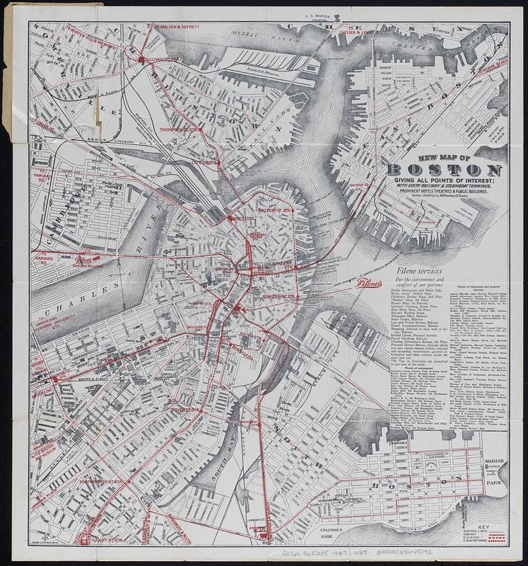
New map of Boston giving all points of interest : with every railway & steamboat terminus, prominent hotels, theatres & public buildings
Viewing image 1 of 2
Next >
New map of Boston giving all points of interest
×
Next
Item Information
Title:
New map of Boston giving all points of interest : with every railway & steamboat terminus, prominent hotels, theatres & public buildings
Title (alt.):
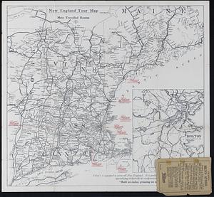
Map of Boston showing transportation lines and points of interest in and about Boston and road map of New England
Publisher:
Walker Lith. & Pub. Co.
Contributor:
William Filene's Sons Co.
Date:
[1926]
Format:
Maps/Atlases
Genre:
Tourist maps
Location:
Boston Public Library
Norman B. Leventhal Map Center
Collection (local):
Norman B. Leventhal Map Center Collection
Subjects:
Boston (Mass.)--Maps
New England--Maps
Places:
Massachusetts
>
Suffolk (county)
>
Boston
New England
(area)
Extent:
1 map ; 47 x 43 cm folded to 14 x 10 cm
Permalink:
https://ark.digitalcommonwealth.org/ark:/50959/vd66zn52n
Terms of Use:
No known copyright restrictions.
No known restrictions on use.
Publisher:
Boston : [publisher not identified]
Scale:
Scale not given
Language:
English
Notes:
Includes advertisement and lists of places of amusement and places of historical and general interest.
New England tour map with inset of Boston Area on verso.
"June, 1926."--Rear cover.
Notes (date):
This date is inferred.
Identifier:
06_01_018329_A
06_01_018329_B
Call #:
G3764.B6E635 1927 .W35
Barcode:
39999065645192
show more...
View MODS XML
More Like This
[Map of New England, 31st]
Telegraph and rail road map of the New England states
A map of the coast of New England from Staten Island to the island ...
The Seat of war, in New England
Find More Like This >>
Tools
Share
Facebook
Pinterest
X
Reddit
Tumblr
Email
Copy link
Add to Folder
Questions/Comments
Cite This Item
IIIF Manifest
Downloads
Primary (full resolution, uncompressed)
(TIF, multi-file ZIP, 155 MB)
Large (full resolution)
(JPEG, multi-file ZIP, 1.37 MB)
Medium
(JPEG, multi-file ZIP, 336 KB)

![[Map of New England, 31st]](https://bpldcassets.blob.core.windows.net/derivatives/images/commonwealth:wd3763094/image_thumbnail_300.jpg)


