Skip to search
Skip to main content
Digital Commonwealth
Folders
Sign Up / Log In
Search for
Search
Search
Search
Basic
Advanced
Explore
Map
Collections
Institutions
Formats
For Educators
Primary Source Sets
Lesson Plans
Using Primary Sources
Searching Digital Commonwealth
For Institutions
Join Digital Commonwealth
Conferences, Trainings, & Events
How to Contribute Collections
Digitization Services
Board & Committees
Frequently Asked Questions
About
About Digital Commonwealth
News & Announcements
Copyright & Terms of Use
Harmful Content Statement
Partners
API
Contact Us
Boston Public Library
Norman B. Leventhal Map & Education Center Collection
/
Urban Maps (Collection of Distinction)
/
Boston and New England Maps (Collection of Distinction)
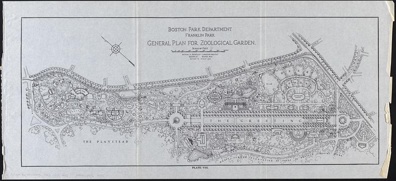
Franklin Park general plan for zoological garden
Franklin Park general plan for zoological garden
×
Item Information
Title:
Franklin Park general plan for zoological garden
Publisher:
Boston (Mass.). Department of Parks
Cartographer:
Shurcliff, Arthur A. (Arthur Asahel), 1870-1957
Name on Item:
Arthur A. Shurtleff, landscape architect
Date:
[1925]
Format:
Maps/Atlases
Location:
Boston Public Library
Norman B. Leventhal Map & Education Center
Collection (local):
Norman B. Leventhal Map & Education Center Collection
Subjects:
Franklin Park (Boston, Mass.)--Maps
Franklin Park (Boston, Mass.)--Planning--Maps
Places:
Massachusetts
>
Suffolk (county)
>
Boston
>
Franklin Park
Extent:
1 map ; 25 x 59 cm
Permalink:
https://ark.digitalcommonwealth.org/ark:/50959/vd66zg13x
Terms of Use:
No known copyright restrictions.
No known restrictions on use.
Publisher:
[Boston] : [Park Department]
Edition:
Revised to March 1923
Scale:
Scale approximately 1:2,600
Language:
English
Notes:
Oriented with north to the upper left.
From Special report 1925 / City of Boston Park Department.
"Plate VIII."
Notes (date):
This date is inferred.
Identifier:
06_01_017821
Call #:
G3764.B6:2F65G45 1923 .S58 1925
Barcode:
39999085963286
show more...
View MODS XML
More Like This
General plan of Franklin Park
Proposed park system from the Common to the West Roxbury Park ...
Topographical map of West Roxbury park
General plan of Franklin Park
Find More Like This >>
Tools
Share
Facebook
Pinterest
X
Reddit
Tumblr
Email
Copy link
Add to Folder
Questions/Comments
Cite This Item
IIIF Manifest
Downloads
Primary (full resolution, uncompressed)
(TIF, 69.9 MB)
Large (full resolution)
(JPEG, 5.87 MB)
Medium
(JPEG, 82.2 KB)