Skip to search
Skip to main content
Digital Commonwealth
Sign Up / Log In
Search for
Search
Search
Search
Basic
Advanced
Explore
Map
Collections
Institutions
Formats
For Educators
Primary Source Sets
Lesson Plans
Using Primary Sources
Searching Digital Commonwealth
For Institutions
Join Digital Commonwealth
Conferences, Trainings, & Events
How to Contribute Collections
Digitization Services
Board & Committees
Frequently Asked Questions
About
About Digital Commonwealth
News & Announcements
Copyright & Terms of Use
Harmful Content Statement
Partners
API
Contact Us
Boston Public Library
Norman B. Leventhal Map Center Collection
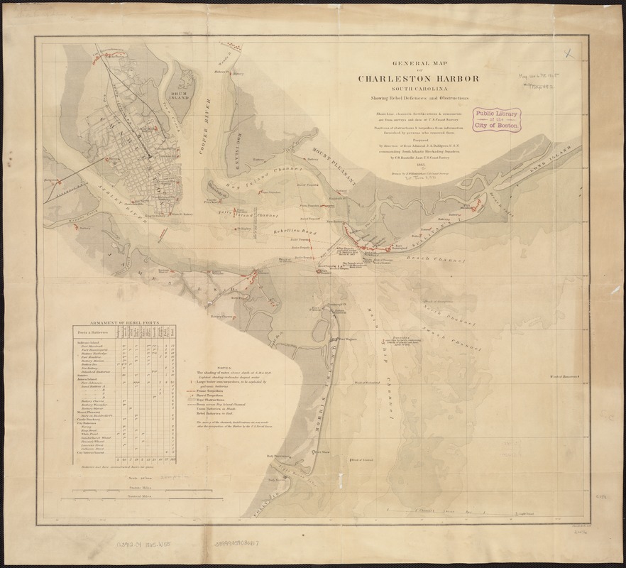
General map of Charleston Harbor South Carolina showing rebel defences and obstructions
General map of Charleston Harbor South Carolina showing rebel defences and obstructions
×
Item Information
Title:
General map of Charleston Harbor South Carolina showing rebel defences and obstructions
Creator:
Willenbücher, Eugene.
Name on Item:
Drawn by E. Willenbücher ; Chas. G. Krebs, Lith.
Date:
1865
Format:
Maps/Atlases
Location:
Boston Public Library
Norman B. Leventhal Map Center
Collection (local):
Norman B. Leventhal Map Center Collection
Subjects:
Shipwrecks--South Carolina--Charleston--Maps
Charleston Harbor (S.C.)--Maps
United States--History--Civil War, 1861-1865--Naval operations--Maps
Places:
Charleston (county)
>
Charleston Harbor
(bay)
Extent:
1 map : col. ; 54 x 61 cm.
Permalink:
https://ark.digitalcommonwealth.org/ark:/50959/kk91fs46f
Terms of Use:
No known copyright restrictions.
No known restrictions on use.
Publisher:
Washington, D.C : [s.n.]
Scale:
Scale 1:30,000.
Language:
English
Notes:
Depths shown by gradient tints.
Shows location of sunken ships.
Includes table of rebel forts.
Identifier:
06_01_007442
Call #:
G3912.C4 1865 .W55
Barcode:
39999059031417
LCCN:
gm 71004125
show more...
View MODS XML
More Like This
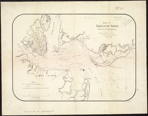
Map of Charleston, S.C., showing the approaches by land and water, ...
Plan of Charleston Harbor, and its fortifications
The 100th anniversary map of Abraham Lincoln's visit to ...
1630 shoreline
Find More Like This >>
Tools
Share
Facebook
Pinterest
X
Reddit
Tumblr
Email
Copy link
Add to Folder
Questions/Comments
Cite This Item
IIIF Manifest
Downloads
Primary (full resolution, uncompressed)
(TIF, 202 MB)
Large (full resolution)
(JPEG, 17 MB)
Medium
(JPEG, 181 KB)
GeoTIFF (georeferenced)
(TIF, 226 MB)