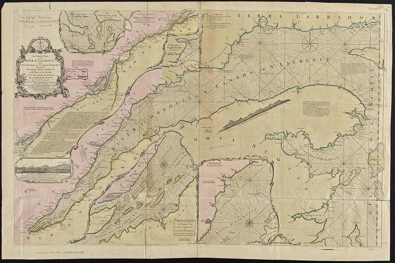
An exact chart of the river St. Laurence, from Fort Frontenac to the island of Anticosti shewing the soundings, rocks, shoals &c with views of the lands and all necessary instructions for navigating that river to Quebec
An exact chart of the river St. Laurence, from Fort Frontenac to the island of Anticosti shewing the soundings, rocks, shoals &c with views of the lands and all necessary instructions for navigating that river to Quebec
Item Information
Title:
An exact chart of the river St. Laurence, from Fort Frontenac to the island of Anticosti shewing the soundings, rocks, shoals &c with views of the lands and all necessary instructions for navigating that river to Quebec
Relief shown pictorially. Soundings in fathoms.
Includes text.
Insets: The Seven Islands -- A continuation of the river from Quebec to Lake Ontario -- St. Nicholas or English Harbor -- The mountains of our Lady or Notre Dame -- The road of Tadousac -- The traverse or passage from Cape Torment into the South Channel of Orleans Island -- A view of the lands from Cape Torment to the Butt as it appears in sailing through the Travers into the South Channel.
Appears in Thomas Kitchin's General Atlas. London: Printed for Robt. Sayer, [1790].

![[Bay of Seven Islands]](https://bpldcassets.blob.core.windows.net/derivatives/images/commonwealth:7h149v48t/image_thumbnail_300.jpg)
![[Chart of the coast of Quebec from the Riviere St. Jean to Grand Hermine Bay]](https://bpldcassets.blob.core.windows.net/derivatives/images/commonwealth:7h149v50v/image_thumbnail_300.jpg)
![[Chart of the gulf and river of St. Lawrence]](https://bpldcassets.blob.core.windows.net/derivatives/images/commonwealth:7h149v39v/image_thumbnail_300.jpg)