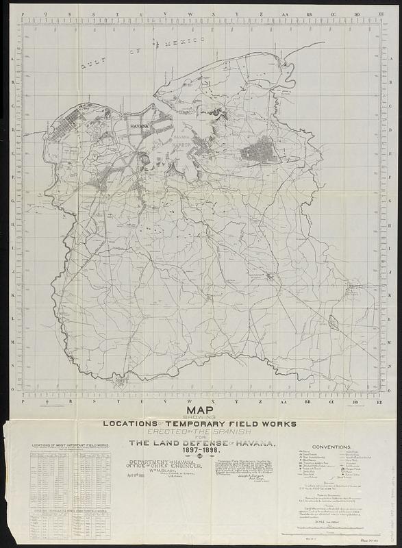
Map showing locations of temporary field works erected by the Spanish for the land defense of Havana, 1897-1898
Map showing locations of temporary field works erected by the Spanish for the land defense of Havana, 1897-1898
Item Information
Title:
Map showing locations of temporary field works erected by the Spanish for the land defense of Havana, 1897-1898
Description:
Map showing defenses in Havana and the surrounding area. Many individual rural households are named. Transportation routes, marshes, mangroves, churches, cemeteries, and many public buildings are named. Hydrography is shown in detail.
Department of Havana, Office of Chief Engineer, Wm. M. Black, Maj., Corps of Engrs., U.S. Army. April 10th 1900 ; working drawing by Pichardo and Bateson ; F.B. Ryons and J.L. Darnell, del.
Detached from Annual reports of the War Department for the fiscal year ended June 30, 1900. Report of the Lieutenant General commanding the army (Washington : Government Printing Office, 1900).
"Temporary Field Works were located by triangulation and referred by rectangular coordinates to Morro Tower as Origin. Main Highways were traversed by stadia. Minor roads and minor details were sketched by Batson [sic] Board Method. Other data chosen from original Spanish sources, after consulting with Sr. Esteban T. Pichardo. Joseph A. Sargent, Asst. Engr., in charge of survey."
"War 56 2."
"Plate No. 125."
Includes notes and indexed tables "Locations of most important field works" and "Important triangulated points other than field works."