Skip to search
Skip to main content
Digital Commonwealth
Sign Up / Log In
Search for
Search
Search
Search
Basic
Advanced
Explore
Map
Collections
Institutions
Formats
For Educators
Primary Source Sets
Lesson Plans
Using Primary Sources
Searching Digital Commonwealth
For Institutions
Join Digital Commonwealth
Conferences, Trainings, & Events
How to Contribute Collections
Digitization Services
Board & Committees
Frequently Asked Questions
About
About Digital Commonwealth
News & Announcements
Copyright & Terms of Use
Harmful Content Statement
Partners
API
Contact Us
Boston Public Library
Norman B. Leventhal Map Center Collection
/
Urban Maps (Collection of Distinction)
/
Boston and New England Maps (Collection of Distinction)
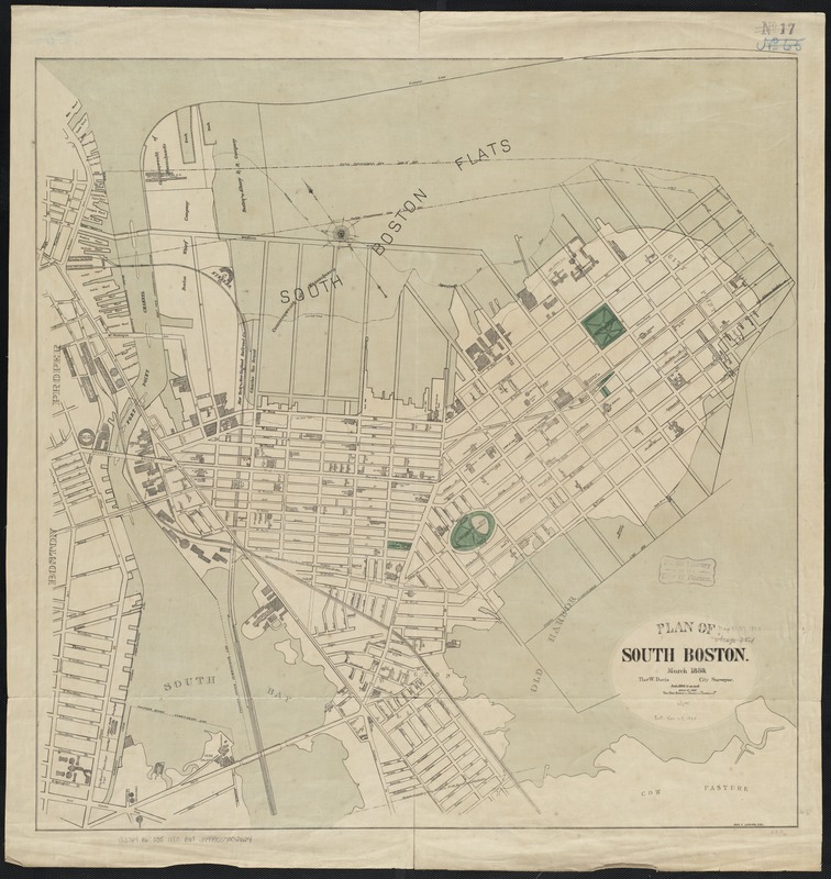
Plan of South Boston
Plan of South Boston
×
Item Information
Title:
Plan of South Boston
Creator:
Boston (Mass.). City surveyor
Name on Item:
Thos. W. Davis ; Geo. F. Loring del.
Date:
[1880]
Format:
Maps/Atlases
Location:
Boston Public Library
Norman B. Leventhal Map Center
Collection (local):
Norman B. Leventhal Map Center Collection
Subjects:
South Boston (Boston, Mass.)--Maps
Places:
Suffolk (county)
>
Boston
>
South Boston
Extent:
1 map : col. ; 77 x 76 cm.
Permalink:
https://ark.digitalcommonwealth.org/ark:/50959/js956k55w
Terms of Use:
No known copyright restrictions.
No known restrictions on use.
Publisher:
Boston, Mass : Engineering Dept.
Scale:
Scale 1:4,800.
Language:
English
Notes:
Oriented with north toward the upper left.
Notes (date):
This date is inferred.
Identifier:
06_01_003896
Call #:
G3764.B6:2S5 1880 .B67
Barcode:
39999059002624
show more...
View MODS XML
More Like This
Atlas of the city of Boston : Dorchester : volume three : from ...
Atlas of the city of Boston : Roxbury, Mass. : volume four : from ...
Atlas of the city of Boston : Roxbury, Mass. : volume four : from ...
Atlas of the city of Boston : Roxbury, Mass. : volume four : from ...
Find More Like This >>
Tools
Share
Facebook
Pinterest
X
Reddit
Tumblr
Email
Copy link
Add to Folder
Questions/Comments
Cite This Item
IIIF Manifest
Downloads
Primary (full resolution, uncompressed)
(TIF, 169 MB)
Large (full resolution)
(JPEG, 14.2 MB)
Medium
(JPEG, 211 KB)
GeoTIFF (georeferenced)
(TIF, 252 MB)