Skip to search
Skip to main content
Digital Commonwealth
Sign Up / Log In
Search for
Search
Search
Search
Basic
Advanced
Explore
Map
Collections
Institutions
Formats
For Educators
Primary Source Sets
Lesson Plans
Using Primary Sources
Searching Digital Commonwealth
For Institutions
Join Digital Commonwealth
Conferences, Trainings, & Events
How to Contribute Collections
Digitization Services
Board & Committees
Frequently Asked Questions
About
About Digital Commonwealth
News & Announcements
Copyright & Terms of Use
Harmful Content Statement
Partners
API
Contact Us
Boston Public Library
Norman B. Leventhal Map Center Collection
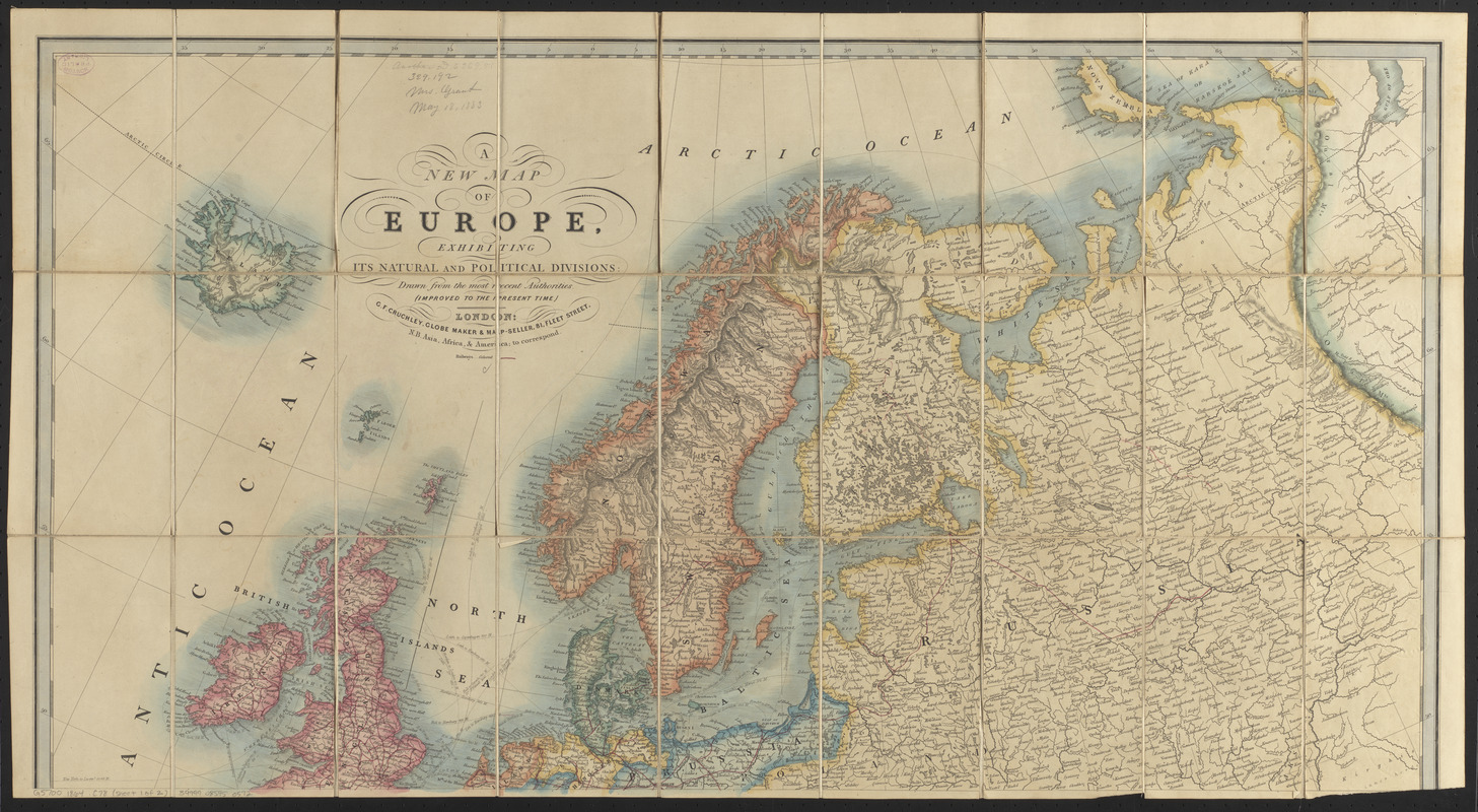
A new map of Europe, exhibiting its natural and political divisions : drawn from the most recent authorities (improves to the present time)
Viewing image 1 of 2
Next >
A new map of Europe, exhibiting its natural and political divisions
×
Next
Item Information
Title:
A new map of Europe, exhibiting its natural and political divisions : drawn from the most recent authorities (improves to the present time)
Title (alt.):
Tourist map of Europe shewing the railways and steam connections
Publisher:
Cruchley, G. F.
Date:
[1864?]
Format:
Maps/Atlases
Location:
Boston Public Library
Norman B. Leventhal Map Center
Collection (local):
Norman B. Leventhal Map Center Collection
Subjects:
Railroads--Europe--Maps
Europe--Maps
Places:
Europe
Europe
Extent:
1 map on 2 sheets : hand color ; 88 x 84 cm, on sheets 48 x 88 cm
Permalink:
https://ark.digitalcommonwealth.org/ark:/50959/jh343z83h
Terms of Use:
No known copyright restrictions.
No known restrictions on use.
Publisher:
London : G.F. Cruchley, globe maker & map-seller, 81, Fleet Street
Scale:
Scale approximately 1:5,800,000
Language:
English
Notes:
Relief shown by hachures.
Identifier:
06_01_016666A
06_01_016666B
Call #:
G5700 1864 .C78
Barcode:
39999085950572
show more...
View MODS XML
More Like This
Bradshaw's map of Europe shewing the railways opened and in progress
Eisenbahn, post und dampfschiffskarte von Europa = Railway, ...
Navigation à vapeur dans le bassin de la Méditerranée et ...
Verkehrs-karte von Europa : übersichts grösserer ...
Find More Like This >>
Tools
Share
Facebook
Pinterest
X
Reddit
Tumblr
Email
Copy link
Add to Folder
Questions/Comments
Cite This Item
IIIF Manifest
Downloads
Primary (full resolution, uncompressed)
(TIF, multi-file ZIP, 156 MB)
Large (full resolution)
(JPEG, multi-file ZIP, 1.38 MB)
Medium
(JPEG, multi-file ZIP, 954 KB)