Skip to search
Skip to main content
Digital Commonwealth
Sign Up / Log In
Search for
Search
Search
Search
Basic
Advanced
Explore
Map
Collections
Institutions
Formats
For Educators
Primary Source Sets
Lesson Plans
Using Primary Sources
Searching Digital Commonwealth
For Institutions
Join Digital Commonwealth
Conferences, Trainings, & Events
How to Contribute Collections
Digitization Services
Board & Committees
Frequently Asked Questions
About
About Digital Commonwealth
News & Announcements
Copyright & Terms of Use
Harmful Content Statement
Partners
API
Contact Us
Boston Public Library
Norman B. Leventhal Map Center Collection
/
Boston and New England Maps (Collection of Distinction)
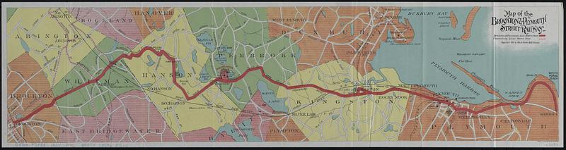
Map of the Brockton & Plymouth street railway
Map of the Brockton & Plymouth street railway
×
Item Information
Title:
Map of the Brockton & Plymouth street railway
Title (alt.):
By trolley inland and alongshore to Plymouth : reached by the Brockton & Plymouth Street Railway Co. : illustrated guide and map
Publisher:
Geo. H. Walker & Co.
Copyright holder:
Stone & Webster
Copyright holder:
Little, Brown and Company
Date:
1901
Format:
Maps/Atlases
Location:
Boston Public Library
Norman B. Leventhal Map Center
Collection (local):
Norman B. Leventhal Map Center Collection
Subjects:
Plymouth (Mass.)--Maps
Plymouth (Mass.)--Description and travel
Street-railroads--Massachusetts--Plymouth--Maps
Street-railroads--Massachusetts--Kingston--Maps
Street-railroads--Massachusetts--Pembroke--Maps
Street-railroads--Massachusetts--Hanson--Maps
Street-railroads--Massachusetts--Whitman--Maps
Street-railroads--Massachusetts--Brockton--Maps
Places:
Plymouth (county)
>
Plymouth
Extent:
1 map : color ; 14 x 57 cm + 1 booklet (27 pages ; 17 cm)
Permalink:
https://ark.digitalcommonwealth.org/ark:/50959/hx121n53w
Terms of Use:
No known copyright restrictions.
No known restrictions on use.
Publisher:
Boston : Geo. H. Walker & Co.
Scale:
Scale approximately 1:71,000
Language:
English
Notes:
Oriented with north to the upper left.
Accompanied by: By trolley inland and alongshore to Plymouth, 1620 : reached by the Brockton & Plymouth Street Railway Co., (27 pages ; 17 cm).
Identifier:
06_01_018553
Call #:
G3764.P7P33 1901 .G46
Barcode:
39999085968517
show more...
View MODS XML
More Like This
Atlas of the boundaries of the town of Plymouth, Plymouth County
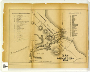
A map of Plymouth Village, 1846
The 100th anniversary map of Abraham Lincoln's visit to ...
1630 shoreline
Find More Like This >>
Tools
Share
Facebook
Pinterest
X
Reddit
Tumblr
Email
Copy link
Add to Folder
Questions/Comments
Cite This Item
IIIF Manifest
Downloads
Primary (full resolution, uncompressed)
(TIF, 35.5 MB)
Large (full resolution)
(JPEG, 2.98 MB)
Medium
(JPEG, 57.7 KB)