Skip to search
Skip to main content
Digital Commonwealth
Sign Up / Log In
Search for
Search
Search
Search
Basic
Advanced
Explore
Map
Collections
Institutions
Formats
For Educators
Primary Source Sets
Lesson Plans
Using Primary Sources
Searching Digital Commonwealth
For Institutions
Join Digital Commonwealth
Conferences, Trainings, & Events
How to Contribute Collections
Digitization Services
Board & Committees
Frequently Asked Questions
About
About Digital Commonwealth
News & Announcements
Copyright & Terms of Use
Harmful Content Statement
Partners
API
Contact Us
Boston Public Library
Norman B. Leventhal Map Center Collection
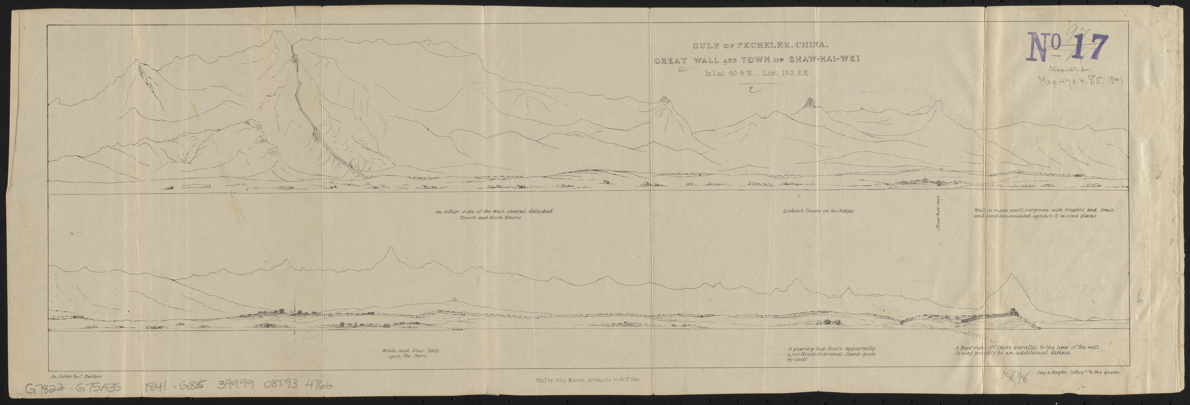
Gulf of Pechelee, China, Great Wall and town of Shaw-hai-wei in lat. 40.4 N. - lon. 120.2 E.
Gulf of Pechelee, China, Great Wall and town of Shaw-hai-wei in lat. 40.4 N. - lon. 120.2 E.
×
Item Information
Title:
Gulf of Pechelee, China, Great Wall and town of Shaw-hai-wei in lat. 40.4 N. - lon. 120.2 E.
Description:
Panoramic view of the coast of the Bohai Sea in 2 sections, showing the Great Wall to the town of Suizhong.
Lithographer:
Burton, Charles, active 1823-1839
Publisher:
Murray, John, 1778-1843
Lithographer:
Day & Haghe
Contributor:
Jocelyn, Robert Jocelyn, Viscount, 1816-1854
Name on Item:
on stone by C. Burton
Date:
1841
Format:
Prints
Location:
Boston Public Library
Norman B. Leventhal Map Center
Collection (local):
Norman B. Leventhal Map Center Collection
Subjects:
Bo Hai (China)--Aerial views
Great Wall of China (China)--Aerial views
Suizhong Xian (China)--Aerial views
Places:
Great Wall of China
Liaoning Sheng
(province)
>
Suizhong
(area)
Bo Hai
Extent:
2 views on 1 sheet ; 16 x 48 cm
Permalink:
https://ark.digitalcommonwealth.org/ark:/50959/ht250b65z
Terms of Use:
No known copyright restrictions.
No known restrictions on use.
Publisher:
Albemarle : John Murray
Scale:
Scale not given
Language:
English
Notes:
From Jocelyn's Six months with the Chinese expedition. London : John Murray, 1841.
Identifier:
06_01_015263
Call #:
G7822.G75A35 1841 .G85
Barcode:
39999085934766
show more...
View MODS XML
More Like This
The 100th anniversary map of Abraham Lincoln's visit to ...
1630 shoreline
1879. Progress map of the U.S. Geographical Surveys west of the ...
1903 Map of Salem and surrounding places
Find More Like This >>
Tools
Share
Facebook
Pinterest
X
Reddit
Tumblr
Email
Copy link
Add to Folder
Questions/Comments
Cite This Item
IIIF Manifest
Downloads
Primary (full resolution, uncompressed)
(TIF, 39.5 MB)
Large (full resolution)
(JPEG, 3.32 MB)
Medium
(JPEG, 449 KB)