Skip to search
Skip to main content
Digital Commonwealth
Sign Up / Log In
Search for
Search
Search
Search
Basic
Advanced
Explore
Map
Collections
Institutions
Formats
For Educators
Primary Source Sets
Lesson Plans
Using Primary Sources
Searching Digital Commonwealth
For Institutions
Join Digital Commonwealth
Conferences, Trainings, & Events
How to Contribute Collections
Digitization Services
Board & Committees
Frequently Asked Questions
About
About Digital Commonwealth
News & Announcements
Copyright & Terms of Use
Harmful Content Statement
Partners
API
Contact Us
Boston Public Library
Norman B. Leventhal Map Center Collection
Das Siebengebirge
Das Siebengebirge
×
Item Information
Title:
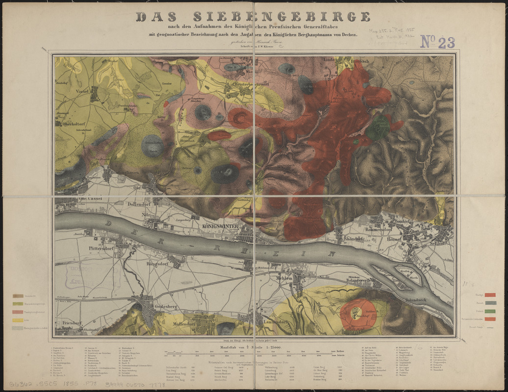
Das Siebengebirge
Cartographer:
Prussia (Kingdom). Armee. Grosser Generalstab
Printer:
Barth, F.
Engraver:
Brose, Heinrich
Contributor:
Dechen, H. von (Heinrich), 1800-1889
Engraver:
Kliewer, F. W.
Publisher:
Berliner Lithographisches Institut
Name on Item:
nach den aufnahmen des Königlichen Preussischen Generalstabes mit geognostischer bezeichnung nach den angaben des Königlichen Berghauptmanns von Dechen ; gestochen von Heinrich Brose ; schrift von F.W. Kliewer
Date:
[1855?]
Format:
Maps/Atlases
Location:
Boston Public Library
Norman B. Leventhal Map Center
Collection (local):
Norman B. Leventhal Map Center Collection
Subjects:
Geology--Germany--Siebengebirge--Maps
Siebengebirge (Germany)--Maps
Places:
North Rhine-Westphalia
>
Siebengebirge
(hill)
Extent:
1 map : color ; 29 x 41 cm
Permalink:
https://ark.digitalcommonwealth.org/ark:/50959/ht250834j
Terms of Use:
No known copyright restrictions.
No known restrictions on use.
Publisher:
Berlin : Druck des Konigl: lith: Instituts
Scale:
Scale 1:25,000
Language:
German
Notes:
Relief shown by hachures.
Oriented with north to the upper left.
Includes list of altitudes and key to points of interest.
Identifier:
06_01_014874
Call #:
G6362.S5C5 1855 .P78
Barcode:
39999065707778
show more...
View MODS XML
More Like This
The 100th anniversary map of Abraham Lincoln's visit to ...
1630 shoreline
1879. Progress map of the U.S. Geographical Surveys west of the ...
1903 Map of Salem and surrounding places
Find More Like This >>
Tools
Share
Facebook
Pinterest
X
Reddit
Tumblr
Email
Copy link
Add to Folder
Questions/Comments
Cite This Item
IIIF Manifest
Downloads
Primary (full resolution, uncompressed)
(TIF, 101 MB)
Large (full resolution)
(JPEG, 8.51 MB)
Medium
(JPEG, 344 KB)