Skip to search
Skip to main content
Digital Commonwealth
Sign Up / Log In
Search for
Search
Search
Search
Basic
Advanced
Explore
Map
Collections
Institutions
Formats
For Educators
Primary Source Sets
Lesson Plans
Using Primary Sources
Searching Digital Commonwealth
For Institutions
Join Digital Commonwealth
Conferences, Trainings, & Events
How to Contribute Collections
Digitization Services
Board & Committees
Frequently Asked Questions
About
About Digital Commonwealth
News & Announcements
Copyright & Terms of Use
Harmful Content Statement
Partners
API
Contact Us
Boston Public Library
Norman B. Leventhal Map Center Collection
/
Urban Maps (Collection of Distinction)
/
Boston and New England Maps (Collection of Distinction)
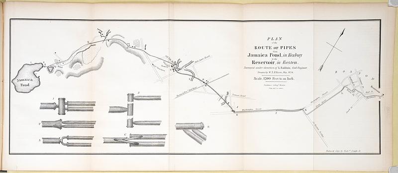
Plan of the route of pipes from Jamaica Pond, in Roxbury to the reservoir, in Boston
Plan of the route of pipes from Jamaica Pond, in Roxbury to the reservoir, in Boston
×
Item Information
Title:
Plan of the route of pipes from Jamaica Pond, in Roxbury to the reservoir, in Boston
Surveyor:
Baldwin, Loammi, 1780-1838
Cartographer:
Ellison, W. S.
Name on Item:
surveyed under direction of L. Baldwin, civil engineer ; drawn by W.S. Ellison
Date:
[1835]
Format:
Maps/Atlases
Location:
Boston Public Library
Central Library in Copley Square
Collection (local):
Boston Public Library Collection
Subjects:
Boston (Mass.)--Maps
Water-supply--Massachusetts--Boston--Maps
Water-pipes--Massachusetts--Boston--Maps
Water-pipes--Pictorial works
Places:
Suffolk (county)
>
Jamaica Pond
(lake)
Suffolk (county)
>
Boston
Extent:
1 map ; 18 x 51 cm
Permalink:
https://ark.digitalcommonwealth.org/ark:/50959/8g84qr74k
Terms of Use:
No known copyright restrictions.
No known restrictions on use.
Publisher:
[Boston] : Hilliard, Gray and Co.
Scale:
Scale 1:14,400. 1200 feet to an inch
Language:
English
Notes:
In "Report on introducing pure water into the city of Boston" / by Loammi Baldwin (Boston : Hilliard, Gray and Co., 1835) facing page 88.
Oriented with north to the upper right.
Relief shown by hachures.
Includes illustrations of pipes.
Notes (date):
This date is inferred.
Identifier:
route-pipes
Call #:
6357.20.1
Barcode:
39999086116496
show more...
View MODS XML
More Like This
Boston water works : map showing the several sources of supply ...
Map of the water region of the county of Middlesex exhibiting the ...
Plan and profiles of surveys from Farm Pond in Framingham and Long ...
Back Bay project no. Mass R-47
Find More Like This >>
Tools
Share
Facebook
Pinterest
X
Reddit
Tumblr
Email
Copy link
Add to Folder
Questions/Comments
Cite This Item
IIIF Manifest
Downloads
Primary (full resolution, uncompressed)
(TIF, 100 MB)
Large (full resolution)
(JPEG, 8.43 MB)
Medium
(JPEG, 38.3 KB)