Skip to search
Skip to main content
Digital Commonwealth
Sign Up / Log In
Search for
Search
Search
Search
Basic
Advanced
Explore
Map
Collections
Institutions
Formats
For Educators
Primary Source Sets
Lesson Plans
Using Primary Sources
Searching Digital Commonwealth
For Institutions
Join Digital Commonwealth
Conferences, Trainings, & Events
How to Contribute Collections
Digitization Services
Board & Committees
Frequently Asked Questions
About
About Digital Commonwealth
News & Announcements
Copyright & Terms of Use
Harmful Content Statement
Partners
API
Contact Us
Boston Public Library
Norman B. Leventhal Map Center Collection
/
Urban Maps (Collection of Distinction)
/
Boston and New England Maps (Collection of Distinction)
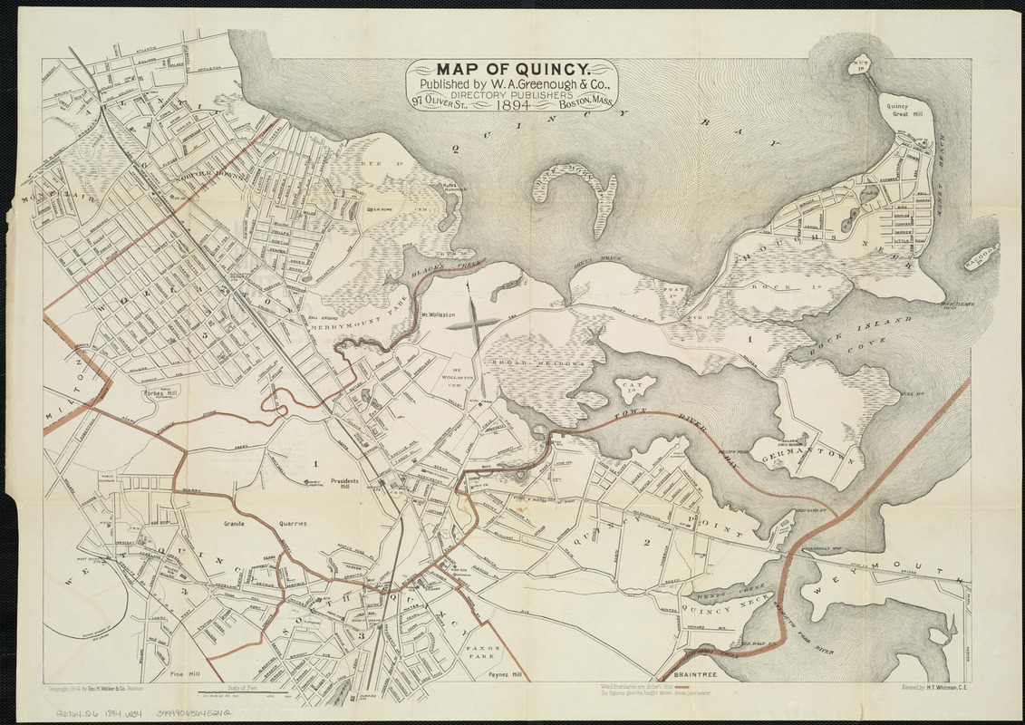
Map of Quincy
Map of Quincy
×
Item Information
Title:
Map of Quincy
Creator:
W. A. Greenough & Co
Name on Item:
revised by H.T. Whitman.
Date:
1894
Format:
Maps/Atlases
Location:
Boston Public Library
Norman B. Leventhal Map Center
Collection (local):
Norman B. Leventhal Map Center Collection
Subjects:
Quincy (Mass.)--Maps
Places:
Norfolk (county)
>
Quincy
Extent:
1 map : some col. ; 48 x 70 cm.
Permalink:
https://ark.digitalcommonwealth.org/ark:/50959/8336h302c
Terms of Use:
No known copyright restrictions.
No known restrictions on use.
Publisher:
Boston : W.A. Greenough & Co.
Scale:
Scale 1:12,000.
Language:
English
Notes:
Shows ward boundaries in red.
Oriented with North toward the upper left.
Copyright 1894 by Geo. H. Walker & Co. Boston.
Identifier:
06_01_007545
Call #:
G3764.Q6 1894 .W34
Barcode:
39999065645242
show more...
View MODS XML
More Like This
Atlas of the city of Quincy, Norfolk County, Mass. : from official ...
Atlas of the city of Quincy, Norfolk County, Massachusetts
Map of Quincy
Map of Quincy
Find More Like This >>
Tools
Share
Facebook
Pinterest
X
Reddit
Tumblr
Email
Copy link
Add to Folder
Questions/Comments
Cite This Item
IIIF Manifest
Downloads
Primary (full resolution, uncompressed)
(TIF, 218 MB)
Large (full resolution)
(JPEG, 18.3 MB)
Medium
(JPEG, 345 KB)