Skip to search
Skip to main content
Digital Commonwealth
Sign Up / Log In
Search for
Search
Search
Search
Basic
Advanced
Explore
Map
Collections
Institutions
Formats
For Educators
Primary Source Sets
Lesson Plans
Using Primary Sources
Searching Digital Commonwealth
For Institutions
Join Digital Commonwealth
Conferences, Trainings, & Events
How to Contribute Collections
Digitization Services
Board & Committees
Frequently Asked Questions
About
About Digital Commonwealth
News & Announcements
Copyright & Terms of Use
Harmful Content Statement
Partners
API
Contact Us
Boston Public Library
Norman B. Leventhal Map & Education Center Collection
/
Urban Maps (Collection of Distinction)
/
Boston and New England Maps (Collection of Distinction)
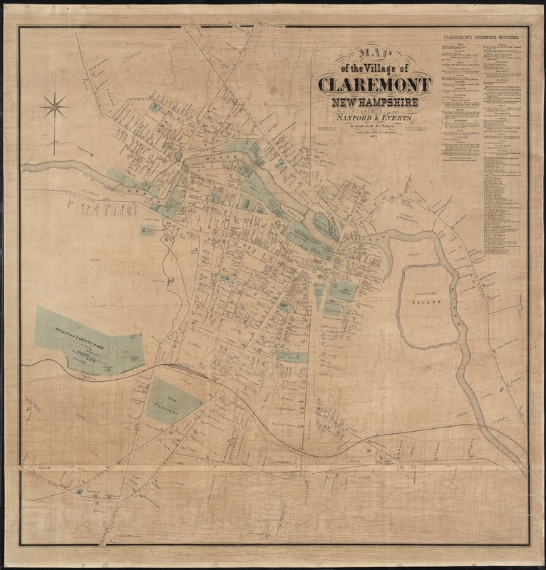
Map of the village of Claremont, New Hampshire
Map of the village of Claremont, New Hampshire
×
Item Information
Title:
Map of the village of Claremont, New Hampshire
Creator:
Sanford, Everts & Co
Name on Item:
by Sanford & Everts ; engd. by Worley & Bracher.
Date:
1873
Format:
Maps/Atlases
Location:
Boston Public Library
Norman B. Leventhal Map & Education Center
Collection (local):
Norman B. Leventhal Map & Education Center Collection
Subjects:
Landowners--New Hampshire--Claremont--Maps
Real property--New Hampshire--Claremont--Maps
Claremont (N.H.)--Maps
Places:
New Hampshire
>
Sullivan (county)
>
Claremont
Extent:
1 map : col. ; 97 x 95 cm.
Permalink:
https://ark.digitalcommonwealth.org/ark:/50959/8336h238j
Terms of Use:
No known copyright restrictions.
No known restrictions on use.
Publisher:
Philadelphia : Sanford and Everts
Scale:
Scale [1:2,400]. 200 ft. to the in.
Language:
English
Notes:
Shows property owners, streets, and railroads.
Lists "Claremont Business Notices."
Cataloging, conservation, and digitization made possible in part by The National Endowment for the Humanities: Exploring the human endeavor.
Identifier:
06_01_007640
Call #:
G3744.C5 1873 .S26
Barcode:
39999065646208
show more...
View MODS XML
More Like This
The 100th anniversary map of Abraham Lincoln's visit to ...
1630 shoreline
1879. Progress map of the U.S. Geographical Surveys west of the ...
1903 Map of Salem and surrounding places
Find More Like This >>
Tools
Share
Facebook
Pinterest
X
Reddit
Tumblr
Email
Copy link
Add to Folder
Questions/Comments
Cite This Item
IIIF Manifest
Downloads
Primary (full resolution, uncompressed)
(TIF, 465 MB)
Large (full resolution)
(JPEG, 39.1 MB)
Medium
(JPEG, 220 KB)