Skip to search
Skip to main content
Digital Commonwealth
Sign Up / Log In
Search for
Search
Search
Search
Basic
Advanced
Explore
Map
Collections
Institutions
Formats
For Educators
Primary Source Sets
Lesson Plans
Using Primary Sources
Searching Digital Commonwealth
For Institutions
Join Digital Commonwealth
Conferences, Trainings, & Events
How to Contribute Collections
Digitization Services
Board & Committees
Frequently Asked Questions
About
About Digital Commonwealth
News & Announcements
Copyright & Terms of Use
Harmful Content Statement
Partners
API
Contact Us
Boston Public Library
Norman B. Leventhal Map & Education Center Collection
/
American Revolutionary War-Era Maps (Collection of Distinction)
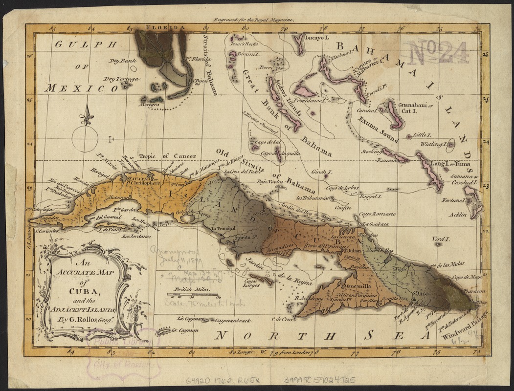
An accurate map of Cuba, and the adjacent islands
An accurate map of Cuba, and the adjacent islands
×
Item Information
Title:
An accurate map of Cuba, and the adjacent islands
Creator:
Rollos, G., fl. 1754-1789
Name on Item:
by G. Rollos.
Date:
[1762]
Format:
Maps/Atlases
Location:
Boston Public Library
Norman B. Leventhal Map & Education Center
Collection (local):
Norman B. Leventhal Map & Education Center Collection
Subjects:
Cuba--Maps--Early works to 1800
Places:
Cuba
Extent:
1 map : col. ; 17 x 24 cm.
Permalink:
https://ark.digitalcommonwealth.org/ark:/50959/6t053q82w
Terms of Use:
No known copyright restrictions.
No known restrictions on use.
Publisher:
London : s.n.
Scale:
Scale ca. 1:4,752,000.
Language:
English
Notes:
Relief shown pictorially.
In upper margin: Engraved for the Royal Magazine.
Notes (date):
This date is inferred.
Identifier:
06_01_006350
Call #:
G4920 1762 .R65x
Barcode:
39999059024925
show more...
View MODS XML
More Like This
Beschryvinghe der eylanden van Cuba, Hispaniola, Iamaica, S. ...
Carta particolare del'Isola di Cuba è di Iamaica con il capo ...
Carta particolare della Baia di Messico con la costa
Carte de l'Isle de Cuba et des Isles Lucayes
Find More Like This >>
Tools
Share
Facebook
Pinterest
X
Reddit
Tumblr
Email
Copy link
Add to Folder
Questions/Comments
Cite This Item
IIIF Manifest
Downloads
Primary (full resolution, uncompressed)
(TIF, 88.3 MB)
Large (full resolution)
(JPEG, 7.41 MB)
Medium
(JPEG, 339 KB)
GeoTIFF (georeferenced)
(TIF, 116 MB)