Skip to search
Skip to main content
Digital Commonwealth
Sign Up / Log In
Search for
Search
Search
Search
Basic
Advanced
Explore
Map
Collections
Institutions
Formats
For Educators
Primary Source Sets
Lesson Plans
Using Primary Sources
Searching Digital Commonwealth
For Institutions
Join Digital Commonwealth
Conferences, Trainings, & Events
How to Contribute Collections
Digitization Services
Board & Committees
Frequently Asked Questions
About
About Digital Commonwealth
News & Announcements
Copyright & Terms of Use
Harmful Content Statement
Partners
API
Contact Us
Boston Public Library
Norman B. Leventhal Map Center Collection
/
American Revolutionary War-Era Maps (Collection of Distinction)
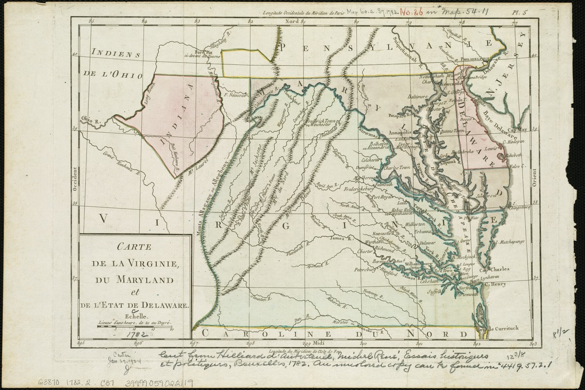
Carte de la Virginie, du Maryland et de l'etat de Delaware
Carte de la Virginie, du Maryland et de letat de Delaware
×
Item Information
Title:
Carte de la Virginie, du Maryland et de l'etat de Delaware
Date:
[1782]
Format:
Maps/Atlases
Location:
Boston Public Library
Norman B. Leventhal Map Center
Collection (local):
Norman B. Leventhal Map Center Collection
Subjects:
Virginia--Maps--Early works to 1800
Maryland--Maps--Early works to 1800
Delaware--Maps--Early works to 1800
Southern States--Maps--Early works to 1800
Places:
Virginia
Maryland
Southern United States
(area)
Delaware
Extent:
1 map : hand col. ; 22 x 32 cm.
Permalink:
https://ark.digitalcommonwealth.org/ark:/50959/6t053p42q
Terms of Use:
No known copyright restrictions.
No known restrictions on use.
Publisher:
Bruxelles : Hilliard d'Auberteuil
Scale:
Scale [ca. 1:2,150,000].
Language:
French
Notes:
Relief shown pictorially.
Prime meridians: Paris and Ferro.
In upper right margin: Pl. 5.
Appears in Hilliard d'Auberteuil's Essais historiques et politiques sur les Anglo-Americains.
Notes (date):
This date is inferred.
Identifier:
06_01_006285
Call #:
G3870 1782.2 .C37
Barcode:
39999059022119
show more...
View MODS XML
More Like This
Carte de la Virginie et du Maryland
A New map of the province of Maryland in North America
The states of Maryland and Delaware, from the latest surveys
A draught of Virginia from the Capes to York in York River and to ...
Find More Like This >>
Tools
Share
Facebook
Pinterest
X
Reddit
Tumblr
Email
Copy link
Add to Folder
Questions/Comments
Cite This Item
IIIF Manifest
Downloads
Primary (full resolution, uncompressed)
(TIF, 43 MB)
Large (full resolution)
(JPEG, 3.61 MB)
Medium
(JPEG, 357 KB)