Skip to search
Skip to main content
Digital Commonwealth
Folders
Sign Up / Log In
Search for
Search
Search
Search
Basic
Advanced
Explore
Map
Collections
Institutions
Formats
For Educators
Primary Source Sets
Lesson Plans
Using Primary Sources
Searching Digital Commonwealth
For Institutions
Join Digital Commonwealth
Conferences, Trainings, & Events
How to Contribute Collections
Digitization Services
Board & Committees
Frequently Asked Questions
About
About Digital Commonwealth
News & Announcements
Copyright & Terms of Use
Harmful Content Statement
Partners
API
Contact Us
Boston Public Library
Norman B. Leventhal Map & Education Center Collection
/
American Revolutionary War-Era Maps (Collection of Distinction)
/
Boston and New England Maps (Collection of Distinction)
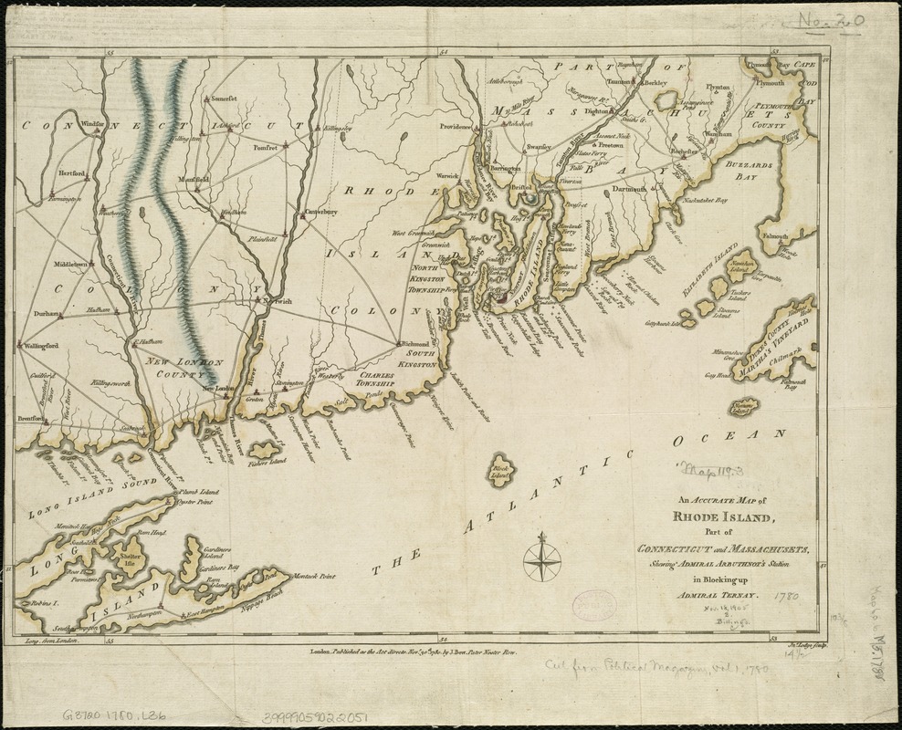
An accurate map of Rhode Island, part of Connecticut and Massachusets, shewing Admiral Arbuthnot's station in blocking up Admiral Ternay
An accurate map of Rhode Island, part of Connecticut and Massachusets, shewing Admiral Arbuthnots station in blocking up Admiral Ternay
×
Item Information
Title:
An accurate map of Rhode Island, part of Connecticut and Massachusets, shewing Admiral Arbuthnot's station in blocking up Admiral Ternay
Creator:
Lodge, John, d. 1796
Name on Item:
Jno. Lodge sculp.
Date:
1780
Format:
Maps/Atlases
Location:
Boston Public Library
Norman B. Leventhal Map & Education Center
Collection (local):
Norman B. Leventhal Map & Education Center Collection
Subjects:
New England--Maps--Early works to 1800
Connecticut--Maps--Early works to 1800
Rhode Island--Maps--Early works to 1800
Massachusetts--Maps--Early works to 1800
United States--History--Revolution, 1775-1783--Naval operations--Maps
Places:
Massachusetts
New England
(area)
Rhode Island
Connecticut
Extent:
1 map : hand col. ; 26 x 37 cm.
Permalink:
https://ark.digitalcommonwealth.org/ark:/50959/6t053p36k
Terms of Use:
No known copyright restrictions.
No known restrictions on use.
Publisher:
London : J. Bew
Scale:
Scale [ca. 1:484,000]
Language:
English
Notes:
Covers Rhode Island, the eastern half of Connecticut, southeastern Massachusetts as far east as Falmouth and Martha's Vineyard, and eastern Long Island.
Relief shown pictorially.
Prime meridian: Ferro; incorrectly marked "London" on map.
Identifier:
06_01_006279
Call #:
G3720 1780 .L63
Barcode:
39999059022051
show more...
View MODS XML
More Like This
An accurate map of Rhode Island, part of Connecticut and ...
A map of the colony of Rhode Island : with the adjacent parts of ...
A map of the province of Massachusets Bay and colony of Rhode ...
A new and accurate map of the colony of Massachusets Bay, in North ...
Find More Like This >>
Tools
Share
Facebook
Pinterest
X
Reddit
Tumblr
Email
Copy link
Add to Folder
Questions/Comments
Cite This Item
IIIF Manifest
Downloads
Primary (full resolution, uncompressed)
(TIF, 53 MB)
Large (full resolution)
(JPEG, 4.45 MB)
Medium
(JPEG, 303 KB)