Skip to search
Skip to main content
Digital Commonwealth
Sign Up / Log In
Search for
Search
Search
Search
Basic
Advanced
Explore
Map
Collections
Institutions
Formats
For Educators
Primary Source Sets
Lesson Plans
Using Primary Sources
Searching Digital Commonwealth
For Institutions
Join Digital Commonwealth
Conferences, Trainings, & Events
How to Contribute Collections
Digitization Services
Board & Committees
Frequently Asked Questions
About
About Digital Commonwealth
News & Announcements
Copyright & Terms of Use
Harmful Content Statement
Partners
API
Contact Us
Boston Public Library
Norman B. Leventhal Map & Education Center Collection
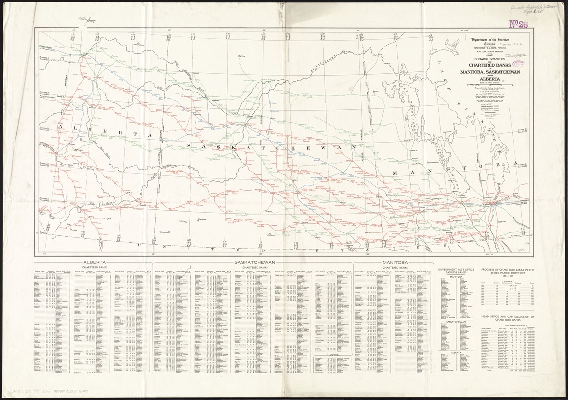
Map showing branches of chartered banks in Manitoba, Saskatchewan and Alberta
Map showing branches of chartered banks in Manitoba, Saskatchewan and Alberta
×
Item Information
Title:
Map showing branches of chartered banks in Manitoba, Saskatchewan and Alberta
Title (alt.):
Chartered banks in Manitoba, Saskatchewan and Alberta
Creator:
Canada. Railway Lands Branch
Name on Item:
prepared in the Railway Lands Branch under the direction of F.C.C. Lynch, superintendent.
Date:
1914
Format:
Maps/Atlases
Location:
Boston Public Library
Norman B. Leventhal Map & Education Center
Collection (local):
Norman B. Leventhal Map & Education Center Collection
Subjects:
Banks and banking--Prairie Provinces--Maps
Railroads--Prairie Provinces--Maps
Prairie Provinces--Commerce--Maps
Manitoba--Maps
Saskatchewan--Maps
Alberta--Maps
Places:
Canada
>
Prairies
(area)
Extent:
1 map : col. ; 42 x 87 cm.
Permalink:
https://ark.digitalcommonwealth.org/ark:/50959/3t947b94s
Terms of Use:
No known copyright restrictions.
No known restrictions on use.
Publisher:
[Ottawa] : Dept. of the Interior
Edition:
2nd ed.
Scale:
Scale [1:1,584,000]. 25 miles to 1 in.
Language:
English
Notes:
Includes index to chartered banks.
Also shows railroads.
Identifier:
06_01_011570
Call #:
G3471.Q8 1914 .C36
Barcode:
39999065686345
show more...
View MODS XML
More Like This
Map showing elevators in Manitoba, Saskatchewan and Alberta
Alberta and western portions of Saskatchewan and Assiniboia
Map showing mounted police stations in the North West Territories
Coal fields of Manitoba and Saskatchewan
Find More Like This >>
Tools
Share
Facebook
Pinterest
X
Reddit
Tumblr
Email
Copy link
Add to Folder
Questions/Comments
Cite This Item
IIIF Manifest
Downloads
Primary (full resolution, uncompressed)
(TIF, 101 MB)
Large (full resolution)
(JPEG, 8.52 MB)
Medium
(JPEG, 292 KB)