Skip to search
Skip to main content
Digital Commonwealth
Sign Up / Log In
Search for
Search
Search
Search
Basic
Advanced
Explore
Map
Collections
Institutions
Formats
For Educators
Primary Source Sets
Lesson Plans
Using Primary Sources
Searching Digital Commonwealth
For Institutions
Join Digital Commonwealth
Conferences, Trainings, & Events
How to Contribute Collections
Digitization Services
Board & Committees
Frequently Asked Questions
About
About Digital Commonwealth
News & Announcements
Copyright & Terms of Use
Harmful Content Statement
Partners
API
Contact Us
Boston Public Library
Norman B. Leventhal Map & Education Center Collection
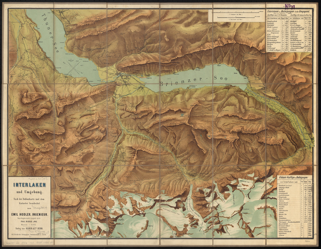
Interlaken und umgebung : nach der dufourkarte und dem kataster bearbeitet durch Emil Hodler, ingenieur
Interlaken und umgebung
×
Item Information
Title:
Interlaken und umgebung : nach der dufourkarte und dem kataster bearbeitet durch Emil Hodler, ingenieur
Title (alt.):
Karte von Interlaken & umgebung
Cartographer:
Hodler, Emil
Cartographer:
Risold, Paul
Lithographer:
Lithographen-genossenschaft in Zürich
Publisher:
Verlag Huber und Co.
Name on Item:
neue ausgabe revidirt & ergänzt durch Paul Risold, Jng.
Date:
[ca. 1880–1889]
Format:
Maps/Atlases
Location:
Boston Public Library
Norman B. Leventhal Map & Education Center
Collection (local):
Norman B. Leventhal Map & Education Center Collection
Subjects:
Interlaken (Switzerland)--Maps
Places:
Switzerland
>
Interlaken
Extent:
1 map : color, dissected and mounted on cloth ; 59 x 79 cm, folded to 21 x 14 cm
Permalink:
https://ark.digitalcommonwealth.org/ark:/50959/0z709608n
Terms of Use:
No known copyright restrictions.
No known restrictions on use.
Publisher:
Bern ; Zürich : Verlag von Huber & cie. ; Lith. & druck der lithographen-genossenschaft.
Edition:
Neue ausgabe revidirt & ergänzt durch Paul Risold, Jng.
Scale:
Scale 1:50,000
Language:
German
Notes:
Relief shown by shading, gradient tints, form lines and spot heights.
Oriented with north to the upper right.
Illustrated title panel and map of Interlaken on verso.
Identifier:
06_01_015168
Call #:
G6044.I6 1880z .H63
Barcode:
39999085932901
show more...
View MODS XML
More Like This
The 100th anniversary map of Abraham Lincoln's visit to ...
1630 shoreline
1879. Progress map of the U.S. Geographical Surveys west of the ...
1903 Map of Salem and surrounding places
Find More Like This >>
Tools
Share
Facebook
Pinterest
X
Reddit
Tumblr
Email
Copy link
Add to Folder
Questions/Comments
Cite This Item
IIIF Manifest
Downloads
Primary (full resolution, uncompressed)
(TIF, 89.7 MB)
Large (full resolution)
(JPEG, 7.53 MB)
Medium
(JPEG, 450 KB)