Skip to search
Skip to main content
Digital Commonwealth
Sign Up / Log In
Search for
Search
Search
Search
Basic
Advanced
Explore
Map
Collections
Institutions
Formats
For Educators
Primary Source Sets
Lesson Plans
Using Primary Sources
Searching Digital Commonwealth
For Institutions
Join Digital Commonwealth
Conferences, Trainings, & Events
How to Contribute Collections
Digitization Services
Board & Committees
Frequently Asked Questions
About
About Digital Commonwealth
News & Announcements
Copyright & Terms of Use
Harmful Content Statement
Partners
API
Contact Us
Boston Public Library
Norman B. Leventhal Map Center Collection
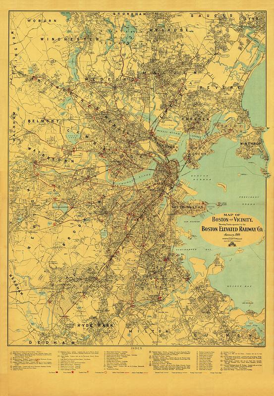
Map of Boston and vicinity, showing tracks operated by the Boston Elevated Railway Co. January, 1910
Map of Boston and vicinity, showing tracks operated by the Boston Elevated Railway Co. January, 1910
×
Item Information
Title:
Map of Boston and vicinity, showing tracks operated by the Boston Elevated Railway Co. January, 1910
Publisher:
Geo. H. Walker & Co.
Publisher:
Walker Lith. & Pub. Co.
Date:
1910
Format:
Maps/Atlases
Location:
Boston Public Library
Norman B. Leventhal Map Center
Collection (local):
Norman B. Leventhal Map Center Collection
Subjects:
Local transit--Massachusetts--Boston--Maps
Railroads, elevated--Massachusetts--Boston--Maps
Subways--Massachusetts--Boston--Maps
Boston (Mass.)--Maps
Boston Elevated Railway Company
Places:
Suffolk (county)
>
Boston
Extent:
1 map : color
Permalink:
https://ark.digitalcommonwealth.org/ark:/50959/0v83bg708
Terms of Use:
No known copyright restrictions.
No known restrictions on use.
Publisher:
Boston : Geo. H. Walker & Co.
Language:
English
Notes:
Shows car houses, power stations, transfer points, connecting lines, surface tracks, elevated tracks, tunnel and subway and foreign tracks.
Includes key to 53 numbered places.
Identifier:
1910-Walker-System
Call #:
G3764.B6P33 svar .B67
Barcode:
39999065669267
show more...
View MODS XML
More Like This
Boston Elevated Railway lines 1921
Boston Elevated Railway lines operated 1925
Boston Elevated Railway system
Boston Elevated Railway track lengths of surface lines and subway
Find More Like This >>
Tools
Share
Facebook
Pinterest
X
Reddit
Tumblr
Email
Copy link
Add to Folder
Questions/Comments
Cite This Item
IIIF Manifest
Downloads
Primary (full resolution, uncompressed)
(TIF, 314 MB)
Large (full resolution)
(JPEG, 26.3 MB)
Medium
(JPEG, 138 KB)