Skip to search
Skip to main content
Digital Commonwealth
Sign Up / Log In
Search for
Search
Search
Search
Basic
Advanced
Explore
Map
Collections
Institutions
Formats
For Educators
Primary Source Sets
Lesson Plans
Using Primary Sources
Searching Digital Commonwealth
For Institutions
Join Digital Commonwealth
Conferences, Trainings, & Events
How to Contribute Collections
Digitization Services
Board & Committees
Frequently Asked Questions
About
About Digital Commonwealth
News & Announcements
Copyright & Terms of Use
Harmful Content Statement
Partners
API
Contact Us
Boston Public Library
Norman B. Leventhal Map Center Collection
/
Boston and New England Maps (Collection of Distinction)
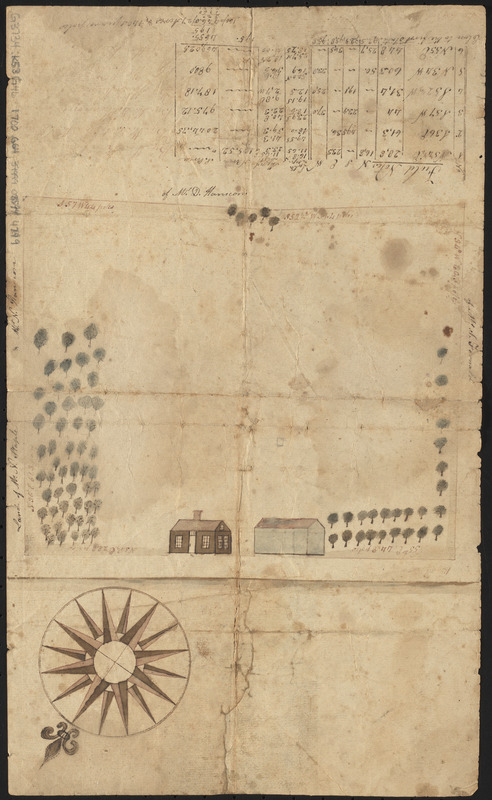
Manuscript survey of a property in Kittery, Maine
Manuscript survey of a property in Kittery, Maine
×
Item Information
Title:
Manuscript survey of a property in Kittery, Maine
Cartographer:
Godsoe, Wm. (William)
Date:
[1700?]
Format:
Maps/Atlases
Manuscripts
Location:
Boston Public Library
Norman B. Leventhal Map Center
Collection (local):
Norman B. Leventhal Map Center Collection
Subjects:
Real property--Maine--Kittery--Maps--Early works to 1800
Landowners--Maine--Kittery--Maps--Early works to 1800
Kittery (Me.)--Maps--Early works to 1800
Manuscript maps--Early works to 1800
Places:
York (county)
>
Kittery
Extent:
1 manuscript map : hand colored ; sheet 34 x 21 cm
Permalink:
https://ark.digitalcommonwealth.org/ark:/50959/0r96fq43n
Terms of Use:
No known copyright restrictions.
No known restrictions on use.
Place of origin:
[Kittery, Maine]
Scale:
Scale approximately 1:2,000
Language:
English
Notes:
Includes illustrations of the dwelling, barn and trees.
Also indicates neighboring property owners.
Includes Field notes table listing surveyor's measurements.
Names next to measurements and in lower left faded and illegible.
Identifier:
06_01_016166
Call #:
G3734.K53G46 1700 .G64
Barcode:
39999085944799
show more...
View MODS XML
More Like This
A plan of Becket protracted by a scale of 120 rods to an inch
The world with all modern discoveries
The 100th anniversary map of Abraham Lincoln's visit to ...
1630 shoreline
Find More Like This >>
Tools
Share
Facebook
Pinterest
X
Reddit
Tumblr
Email
Copy link
Add to Folder
Questions/Comments
Cite This Item
IIIF Manifest
Downloads
Primary (full resolution, uncompressed)
(TIF, 39.9 MB)
Large (full resolution)
(JPEG, 3.35 MB)
Medium
(JPEG, 153 KB)