Skip to search
Skip to main content
Digital Commonwealth
Folders
Sign Up / Log In
Search for
Search
Search
Search
Basic
Advanced
Explore
Map
Collections
Institutions
Formats
For Educators
Primary Source Sets
Lesson Plans
Using Primary Sources
Searching Digital Commonwealth
For Institutions
Join Digital Commonwealth
Conferences, Trainings, & Events
How to Contribute Collections
Digitization Services
Board & Committees
Frequently Asked Questions
About
About Digital Commonwealth
News & Announcements
Copyright & Terms of Use
Harmful Content Statement
Partners
API
Contact Us
Boston Public Library
Norman B. Leventhal Map Center Collection
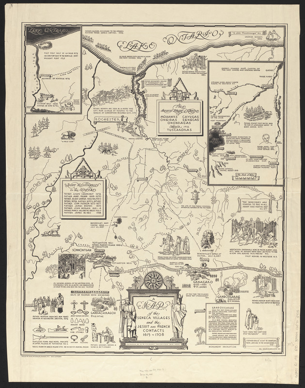
A map of the Seneca villages and the Jesuit and French contacts 1615-1708
A map of the Seneca villages and the Jesuit and French contacts 1615-1708
×
Item Information
Title:
A map of the Seneca villages and the Jesuit and French contacts 1615-1708
Cartographer:
Erickson, Helen M.
Author:
Stewart, Alexander McGinn
Name on Item:
research by A.M. Stewart ; del. Helen M. Erickson
Date:
1931
Format:
Maps/Atlases
Location:
Boston Public Library
Norman B. Leventhal Map Center
Collection (local):
Norman B. Leventhal Map Center Collection
Subjects:
Seneca Indians--New York (State)--Maps
Indians of North America--New York (State)--Maps
New York (State)--Maps
Places:
New York
Extent:
1 map ; 65 x 51 cm
Permalink:
https://ark.digitalcommonwealth.org/ark:/50959/0r96fm57c
Terms of Use:
No known copyright restrictions.
No known restrictions on use.
Publisher:
Rochester, N.Y. : Alexander M. Stewart
Scale:
Scale approximately 1:80,000
Language:
English
Notes:
Pictorial map with historical notes.
Insets: [Niagara River area] -- [Lake Ontario, St. Lawrence River area.].
Accompanied by text titled: A guide to the map of Seneca villages and Jesuit and French connections.
Identifier:
06_01_014754
Call #:
G3801.E1 1931 .E75
Barcode:
39999065705418
show more...
View MODS XML
More Like This
Connecticut with portions of New York & Rhode Island
E.P. Dutton & Co.'s railroad, steam boat & stage route map of New ...
Hale's map of the central & western parts of Massachusetts, with a ...
Map exhibiting the rail road, canal, lake and river routes from ...
Find More Like This >>
Tools
Share
Facebook
Pinterest
X
Reddit
Tumblr
Email
Copy link
Add to Folder
Questions/Comments
Cite This Item
IIIF Manifest
Downloads
Primary (full resolution, uncompressed)
(TIF, 101 MB)
Large (full resolution)
(JPEG, 8.45 MB)
Medium
(JPEG, 247 KB)