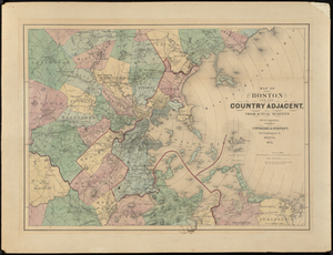
Plan of Boston
Item Information
- Title:
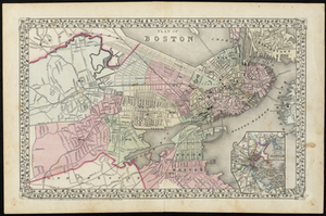
- Plan of Boston
- Description:
-
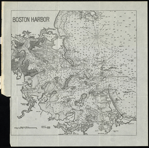
Ancillary map: Map of the country around Boston showing also its harbor & islands. Boston (Mass.) --Maps, Boston, Brookline, Charles River, Charlestown, Public Garden, Boston Common, East Boston, Boston Harbor, South Bay, Dorchester, South Boston, Washington Village, Middlesex, Essex, Norfolk, Nahant Bay, Lynn Harbor, Lynn, Saugus, Melrose, Malden, Malden Centre, Medford, Plymouth, Hingham, Quincy, Milton, Jamaica Plains, Roxbury, Brighton, Cambridge, Somerville, Snake Island, Governor's Island, Fort Winthrop, Castle Island, Deer Island, Green Island, Calf Island, Fort Warren, Lovell's Island, Fort Independence, Gallop's Island, George's Island, Rainsford's Island, Nantasket, Thompson's Island, Moon Island, Pedock's Island, Pumpkin Island, Sheaf Island, Grape Island, boston, massachusetts.
- Creator:
- Mitchell, S. Augustus
- Date:
-
1890
- Format:
-
Maps/Atlases
- Location:
- Salem State University Archives and Special Collections
- Collection (local):
-
Historic Maps
- Series:
- Boston
- Subjects:
-
Boston (Mass.)--Maps
Boston
Brookline
Charles River
Charlestown
Public Garden
Boston Common
East Boston
Boston Harbor
South Bay
Dorchester
South Boston
Washington Village
Middlesex
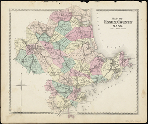
Essex
Norfolk
Nahant Bay
Lynn Harbor
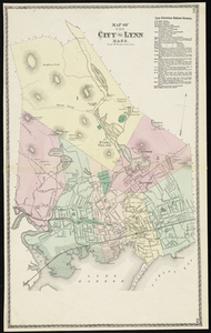
Lynn
Saugus
Melrose
Malden
Malden Centre
Medford
Plymouth
Hingham
Quincy
Milton
Jamaica Plains
Roxbury
Brighton
Cambridge
Somerville
Snake Island
Governor's Island
Fort Winthrop
Castle Island
Deer Island
Green Island
Calf Island
Fort Warren
Lovell's Island
Fort Independence
Gallop's Island
George's Island
Rainsford's Island
Nantasket
Thompson's Island
Moon Island
Pedock's Island
Pumpkin Island
Sheaf Island
Grape Island
Massachusetts
- Places:
-
Massachusetts > Suffolk (county) > Boston
- Link to Item:
- http://digitalcommons.salemstate.edu/maps_boston/64
- Terms of Use:
-
Rights status not evaluated.
Contact host institution for more information.
- Identifier:
-
G 3764 .B6 1890 .M5