Skip to search
Skip to main content
Digital Commonwealth
Sign Up / Log In
Search for
Search
Search
Search
Basic
Advanced
Explore
Map
Collections
Institutions
Formats
For Educators
Primary Source Sets
Lesson Plans
Using Primary Sources
Searching Digital Commonwealth
For Institutions
Join Digital Commonwealth
Conferences, Trainings, & Events
How to Contribute Collections
Digitization Services
Board & Committees
Frequently Asked Questions
About
About Digital Commonwealth
News & Announcements
Copyright & Terms of Use
Harmful Content Statement
Partners
API
Contact Us
State Library of Massachusetts
Massachusetts Board of Railroad Commissioners
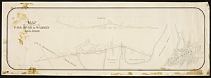
Map of the projected New Bedford and Fall River Railway / from surveys by George E. Church, engineer.
View this item online at State Library of Massachusetts
Item Information
Title:
Map of the projected New Bedford and Fall River Railway / from surveys by George E. Church, engineer.
Format:
Maps/Atlases
Location:
State Library of Massachusetts
Collection (local):
Massachusetts Board of Railroad Commissioners
Series:
Maps
Subjects:
Fall River (Mass.)--Maps
Cook Pond (Mass.)--Maps
Watuppa Pond (Mass.)--Maps
Westport (Mass.)--Maps
Dartmouth (Mass.)--Maps
New Bedford (Mass.)--Maps
Places:
Massachusetts
>
Bristol (county)
>
Westport
Massachusetts
>
Bristol (county)
>
Dartmouth
Massachusetts
>
Middlesex (county)
>
Bedford
Massachusetts
>
Bristol (county)
>
Fall River
Extent:
1 map 30 x 205 in.
Link to Item:
http://archives.lib.state.ma.us/handle/2452/70893
Terms of Use:
Rights status not evaluated.
Contact host institution for more information.
Notes:
Manuscript.
Map Mass. R.R. #160
Identifier:
esl10132819
show more...
View MODS XML
More Like This
Atlas of the boundaries of the cities of Fall River - New Bedford ...
Atlas of Massachusetts
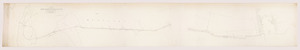
Map of the route of the Fall River & Warren Railroad.
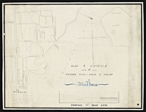
Map & profile of branch rail-road & wharf in New Bedford
Find More Like This >>
Tools
Share
Facebook
Pinterest
X
Reddit
Tumblr
Email
Copy link
Add to Folder
Questions/Comments
Cite This Item
![Atlas of the boundaries of the cities of Fall River - New Bedford and towns of Acushnet, Berk[e]ley, Dartmouth, Dighton, Fairhaven, Freetown, Somerset, Swansea, Westport, Bristol County](https://bpldcassets.blob.core.windows.net/derivatives/metadata/commonwealth-oai:1r66jh22w/image_thumbnail_300.jpg)